|
|
|
|
|
We hope you enjoy our newsletter and we appreciate any questions, comments or corrections by email to our Webmaster/Newsletter Editor: Lloyd DeKay
|
|
|
|
Explore the Ice Age Floods ... and More
|
This month we concentrate on southern areas of the Columbia River
|
|
|
|
|
|
|
|
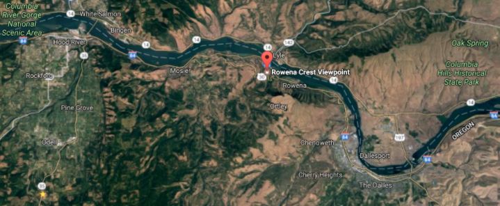
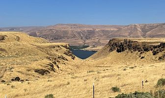
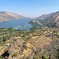
Scenic Rowena Crest, at (45.68272, -121.29924), and the Tom McCall Preserve area provide an incredibly scenic place to let your feet, and your imagination wander as you look out on a major chokepoint along the Ice Age Floods path. The wildflower displays are amazing during the Spring, but several compelling flood-related features are visible from the vantage of the Rowena Crest Viewpoint any time of year. Rowena Crest lies nearly 700 feet above the Columbia River at the upstream end of the Rowena Plateau, a miles-long plateau that the river flows along. Just upriver from the plateau is the narrow section of the Gorge known as the Rowena Gap The drive to the viewpoint on old Hwy 30 from either east or west is a spectacular ride through a wonderous section of the Columbia River Gorge. A roundabout parking area at the viewpoint, with a safety wall above a sheer cliff, provides a great observation point eastward, toward Rowena Gap. At Rowena Crest it's easy to imagine what it might have been like to witness the approach of those massive floods.
|
|
There is not yet scientific evidence that humans were in the area to bear witness to the Ice Age Floods, but there is solid evidence of humans in the Americas by that time. And there is growing concensus that if they came in during a glacial maximum, they would have come in by a coastal route that offered plentiful food and shelter for their journey. The mouth of the Columbia River would have been the first major waterway path inland that might have led them to settle in the area of the Floods.
|
|
|
|
Your village might have been situated across the Columbia at the mouth of the Klickitat River where the town of Lyle now sits. If you were foraging, or just relaxing, atop Rowena Crest on a late summer day, you might have felt the ground begin to temble as if there were a small earthquake, but the trembling would have slowly increased for a few hours. Eventually you would have heard a low roaring sound that also grew over an hour or more before you could see turbulent brown muddy water begin flooding across the broad basin to the east.
Then the roaring flood of water, only a few feet deep at first, would have entered the narrows, now called Rowena Gap, and sped on, crashing against the promontory you're standing on and being diverted toward your village which was quickly washed away by the muddy torrent. But the muddy flood waters would have kept rising, unlike the Spring floods you're used to on the Columbia, becoming a hundred feet deep, then two hundred as the levels just kept rising. Soon a huge whirlpool formed in the flood waters near the base of the promontory and a giant eddy formed where your village had been as flood waters flowed backward up the Klickitat River even as the bulk of the water continued downstream on the main stem of the Columbia.
As the flood waters reached 400 and 500 feet deep and kept coming, suddenly to your right a huge block of the promontory broke off and slumped down into the rampaging flood waters. Now you would have begun running south toward higher ground, climbing higher and higher as the still rising flood waters poured across the plateau and plunged into the small creek valley to the west, tearing away at the valley walls and massively widening that little valley. Eventually the flood waters stopped chasing you upward as you climbed higher, 200 then 300 feet above the now submerged promontory. Now as you turned and looked out across that expanse of muddy water you could see massive white blocks of ice being carried along on the flood waters, similar but inconceiveably larger than the ice blocks carried on the river during the Spring floods.
But the flood waters didn't begin to recede that day, nor the next, as they might in the Spring floods. In fact it was almost half a lunar cycle before they began to slowly recede, exposing a mud coated Columbia River valley that was now noticably wider, with layers of shear vertical rock walls extending over 1000 feet above the normal river level below. As you began the recovery from the floods devastation, your family returned from their hunting and gathering in the high mountain meadows, and you have an incredible story to pass along to them and your ancestors.
|
|
|
|
This story is easy to imagine as you look out to the east from Rowena Crest. The onrushing Ice Age Floods waters easily flowed over the low relief of the broad Dalles Basin to the east, but the major Rowena Gap created a chokepoint in the path of the floods as they made their way through the Columbia River Gorge.
|
|
|
|
|
|
|
The "hydraulic dam" forced the flood waters to build to over 1000 feet deep in this area, flowing hundreds of feet deep over Rowena Crest while forming a temporary lake in The Dalles basin. It is estimated that many of the 40-100 Ice Age Floods may have taken up to a month to completely flush through the system to the Pacific Ocean, but the duration of the flood waters at any point along the path probably lasted less than a couple of weeks. But this was more than enough to create several major floods features visible from this vantage point.
|
|
|
|
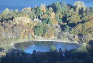
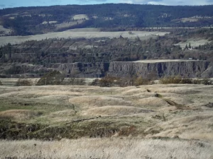
Kolk pond on the Columbia
|
|
At Columbia River level below and east of the promontory is a round Kolk pond that was created by giant whirlpools in the flood waters as they were deflected around the Rowena Crest promontory. Other similar Kolk features can also be seen on the Dallesport area to the east, and along the hiking path atop Rowena Crest where they are marked by surrounding groves of oak trees.
|
|
|
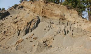
Sand/gravel beds growing upstream
|
|
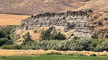
Across the Columbia, the floods deposited a huge eddy gravel bar that the entire town of Lyle, Washington is built upon. The Klickitat River was backed up for miles upstream, as evidenced by sand and gravel beds growing upstream in a quarry over 400 feet above the Columbia River at the junction of Old Highway 8 and Canyon Road.
|
|
|
|
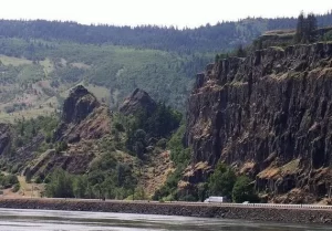
Slump blocks viewed from Washington
|
|
Below the edge of the viewpoint, a number of large tilted blocks of layered of Columbia River Basalt are slump blocks, undercut by the flood waters crashing against the promontory, that broke off and slid toward the river from the prominent indentation in the cliff face just to the south of the overlook. These slump blocks can also be clearly seen from the Washington side of the River.
|
|
|
|
Mima/Desert/Biscuit Mounds at Tom McCall Preserve
|
|
The ephemeral Rowena Creek flows through a massively oversized valley to the west of the Preserve area, and hundreds of low, rounded mounds cover the Preserve area. These enigmatic mounded features are variously called Mima-, Desert-, or Biscuit-mounds. Similar features abound locally and worldwide, but their origins are not definitively known. Here they might have been formed by turbulence at the base of the flood waters flowing over the plateau, but sediment-trapping by plants or glacial suncups, segregation by freeze/thaw processes or earthquake vibrations, even digging by giant Pleistocene gophers have all been suggested as causes of these features where they're found in different areas. But origins of the mounds in the middle of the roundabout parking area are known. They were built by Oregon Dept. of Transportation to mimic those that cover the plateau.
|
|
|
|
|
Article and story written by Lloyd DeKay, IAFI Webmaster, Newsletter Editor and Columbia River Gorge Chapter President. Any misstatements or mis-interpretations are mine alone.
|
|
|
|
|
|
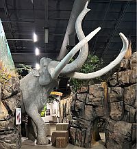
Tualatin, Oregon, lies in its own valley near the head of the Willamette Valley. In the time of the Ice Age floods, about 18,000 years ago, the area was a rich wetland. The gift those floods left behind was a hearty silt containing loess that was picked up from lands in eastern Washington in the rush of the flood waters. The deposited loess supported abundant plant life that supported the megafauna animals that benefitted from this rich land, including Columbian mammoths, mastodons, giant sloths, grey wolves, the first horses, bison and others in the Pleistocene Age. In today’s world, fossil hunting for these extinct animals is a fruitful treasure hunt and celebrated in the Tualatin area.
|
|
Tualatin has helped lead the way in displaying Ice Age fossils at various family friendly sites in the City:
|
|
|
|
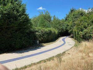
Tualatin Greenway: To the right and behind the Library/City Building is the entrance to the Tualatin Greenway, a trail system along the Tualatin River. It is complete with signage concerning Ice Age Floods. The primary trail is a long winding concrete path with a blue meandering mosaic center strip representing Tualatin’s part of the Ice Age Floods National Geologic Trail. It’s a favorite for joggers, cyclists and those who love to walk.
|
|
|
|
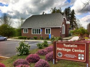
Tualatin Heritage Center: Here, Columbian mammoth and mastodon tusks are featured among other ice-age large granite boulder erratics on display outside, all with explanatory plaques. 8700 SW Sweek Dr., Tualatin, Oregon 97062
|
|
|
|
|
|
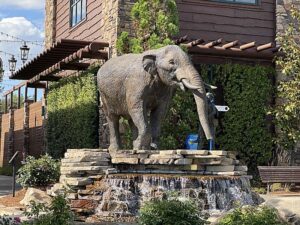
Cabela’s Shopping Center: Return from the Greenway to the front of the shopping center building. See the full-size juvenile mastodon sculpture being admired by a farm boy holding a spade with which to find a fossil skeleton. At his farm, a molar tooth is a barn doorstop. Read the story on the plaque. Brian Keith is the sculptor. Inside Cabela’s store, see the Cave at the back which shows Ice Age fossils displayed in context.
|
|
|
|
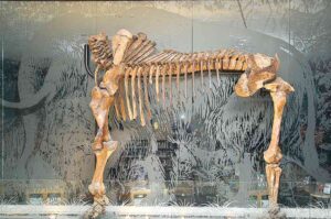
Tualatin Public Library: Enter, and the first thing you see is the mastodon skeleton displayed high behind the checkout desk framed in an etched glass panel depicting the grassland and the mastodon’s body. This fossil skeleton was discovered nearby during a site excavation for a large retail store. Further on into the Library are a group of lighted display cabinets for fossils arranged on shelves. The cabinets are arranged side by side in a gentle arc for easy family viewing. 18878 SW Martinazzi, Tualatin, 97062.
|
|
|
|

|
|
|
|
Article authors, Charles Hall and Jane Walpole, are President and Vice President of the Lower Columbia Chapter of IAFI
|
|
|
|
|
|
|
|
After an exciting summer of floods, stories, and events around the Grand Coulee and J Harlen Bretz's centennial publication on the channeled scabland, it was time to change scenery. I asked Richard Waitt and Jim O'Conner from the Portland office of the US Geologic Survey to join Lloyd DeKay and I for a visit to the Ice Age floods sites east of the Columbia River National Scenic Area. Richard and Jim have contributed significantly to our better understanding of the Missoula Floods and Lloyd DeKay is our IAFI Columbia Chapter President and webmaster.
|
|
|
|
We started our visit by stopping at the Columbia River Discovery Center in Dallas, Oregon. The Center is a great place to learn more about the region, the history of geology, and events that have passed through this part of the world.
|
|
|
|
From there, we headed east along the Columbia River until we reached Fifteenmile Mile Creek. Richard and Jim pointed out places where the Ice Age floods had overtopped the ridges to the south of the Columbia River.
|
|
|
|
Jim explained how layered deposits from eddy's formed after cresting the ridge, and slack water deposits, from back flooding up Fifteenmile Creek caused by downstream constrictions at The Dalles, can be found together.
|
|
|
|
|
From the ridge above Fifteenmile, looking down towards the Columbia River, you can see a clear path where flood waters crested over the ridge and channeled scabland on plateaus above the river.
|
|
|
|
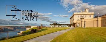
At Biggs Junction, we crossed over to the Washington side of the river and headed back west with a stop at the Maryhill Museum of Art. The grounds there offer great views of the Columbia River.
|
|
|
|
We stopped at several other places along Highway 14 with signs of the floods passing through. Crawford Oaks Trailhead and Horsethief Butte Trail are right off the highway and part of Columbia Hill Historical State.
|
|
|
|
After crossing back to Oregon, we headed further west to Rowena Crest, the first location inside the Columbia River National Scenic Area.
|
|
|
This eastern section of the Columbia River is a spectacular place to see signs of the Missoula Floods and grow a deeper understanding of how Ice Age floods helped shape this part of the world
|
|
|
One of my big takeaways from our trip was that the Columbia Gorge is beautiful, scenic, and lush. Still, if you really want to see clear flood signs in the landscape along the Columbia River, you must move more to the east. A big thanks to our friends at USGS and IAFI for coming together to explore this part of the world and share a deeper understanding of how Ice Age floods impacted the world around us.
|
|

|
|
|
|
Justin Radford is Program Manager for the Ice Age Floods National Geologic Trail
|
|
|
|
|
|
|
Answers to questions and interesting articles about things related to the Ice Age Floods
|
|
|
|
|
|
|
|
|
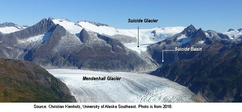
Mendenhall Glacier and other glaciers above Juneau, Alaska, while rapidly receding are trapping meltwaters that are more frequently being released as devastating 'glacial outburst floods' in mini-examples of the processes that produced the Ice Age Floods. The Washington Post recently produced a detailed article about the Aug. 5th flood that roared through Juneau on the order of a 500-year flood.
|
|
|
|
On the morning of Aug. 4 ... “Looks like the basin is going.”
The U.S. Geological Survey (USGS) gauge at Mendenhall Lake — at the foot of the glacier — was showing water levels rising sharply. ... All summer, a jumble of icebergs and meltwater had been filling Suicide Basin. And when it eventually flushed out, as it had done more than 30 times since 2011, the water would pour into Mendenhall Lake and down the river to Juneau.
Click here to view media.
... The glacier normally served as a dam for that reservoir of ice melt and rainwater, but when enough of it accumulated, the tremendous pressure could lift the glacier and let water escape underneath. This was known as going “subglacial.” When that happened ... the passageway within the glacier can rapidly expand, emptying billions of gallons of water downstream in a matter of hours ...
|
|
|
|
|
About a week later,water began overtopping the ice dam and flowing down along the glacier’s flank.
The glacier normally served as a dam for that reservoir of ice melt and rainwater, but when enough of it accumulated, the tremendous pressure could lift the glacier and let water escape underneath. This was known as going “subglacial.” When that happened ... the passageway within the glacier can rapidly expand, emptying billions of gallons of water downstream in a matter of hours ... About a week later,water began overtopping the ice dam and flowing down along the glacier’s flank.
When this overtopping had happened in two previous years, the water found its subglacial escape hatch about a week later. But each year the glacier is changing, and the holes made the summer before may be gone. No one knew exactly when it might burst. On Aug. 4, with lake levels rising, the National Weather Service issued a warning predicting that Mendenhall Lake would peak the following evening around 10.7 feet — about five feet above its typical level ... the next day ... observing the raging river as water levels surpassed that initial projection and then kept going beyond the 12-foot record set in July 2016. Before the night was over, it would rise three feet higher.
Excerpted from Washington Post, Sept. 4th article by Joshua Partlow
|
|
|
|
|
|
|
|
|
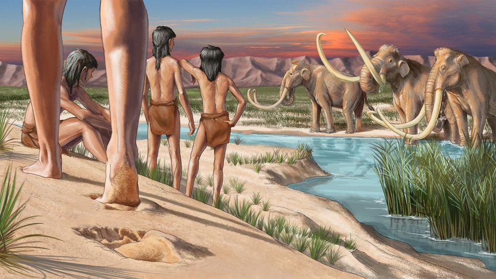
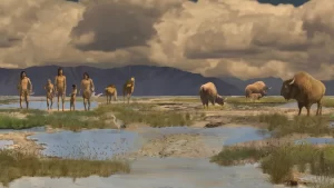
During the last ice age, humans ventured into two vast and completely unknown continents: North and South America. For nearly a century, researchers thought they knew how this wild journey occurred: The first people to cross the Bering Land Bridge, a massive swath of land that connected Asia with North America when sea levels were lower, were the Clovis, who made the journey shortly before 13,000 years ago. According to the Clovis First theory, every Indigenous person in the Americas could be traced to this single, inland migration, said Loren Davis, a professor of anthropology at Oregon State University. But in recent decades, several discoveries have revealed that humans first reached the so-called New World thousands of years before we initially thought and probably didn't get there by an inland route. So who were the first Americans, and how and when did they arrive?
|
|
|
Genetic studies suggest that the first people to arrive in the Americas descend from an ancestral group of Ancient North Siberians and East Asians that mingled around 20,000 to 23,000 years ago and crossed the Bering Land Bridge sometime between then and 15,500 years ago. Geneticists studying the first Americans tend to paint a more consistent picture than archaeologists do, mainly because they're using the same human remains and genetic datasets. Genetic analyses have found that Ancient North Siberians and a group of East Asians paired up around 20,000 to 23,000 years ago. Soon after, the population split into two genetically distinct groups: one that stayed in Siberia, and another, the basal American branch, which emerged around 20,000 to 21,000 years ago. Genetic data suggest the descendants of this basal American branch crossed the Bering Land Bridge and became the first Americans.
|
|
|
|
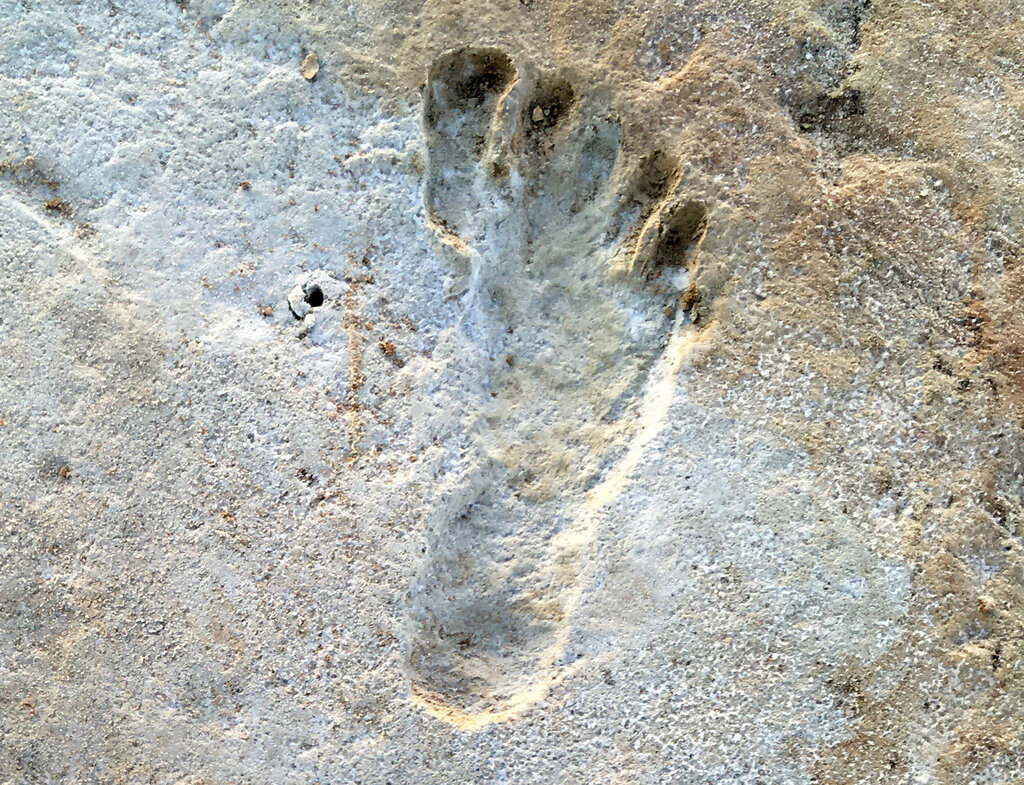
But some archaeological sites hint that people may have reached the Americas far earlier than that. There are fossilized human footprints in White Sands National Park in New Mexico that may date to 21,000 to 23,000 years ago. That would mean humans arrived in North America during the Last Glacial Maximum (LGM), which occurred between about 26,500 to 19,000 years ago, when ice sheets covered much of what is now Alaska, Canada and the northern U.S. Other, more equivocal data suggest the first people arrived in the Western Hemisphere by 25,000 or even 31,500, years ago. If these dates can be confirmed, they would paint a much more complex picture of how and when humans reached the Americas.
|
|
|
Almost all scientists agree, however, that this incredible journey was made possible by the emergence of Beringia — a now-submerged, 1,100-mile-wide (1,800 kilometers) landmass that connected what is now Alaska and the Russian Far East. During the last ice age, much of Earth's water was frozen in ice sheets, causing ocean levels to fall. Beringia surfaced once waters in the North Pacific dropped roughly 164 feet (50 meters) below today's levels; it was passable by foot between 30,000 and 12,000 years ago. From there, the archaeological picture gets muddier.
|
|
|
Click on graphic to enlarge
|
|
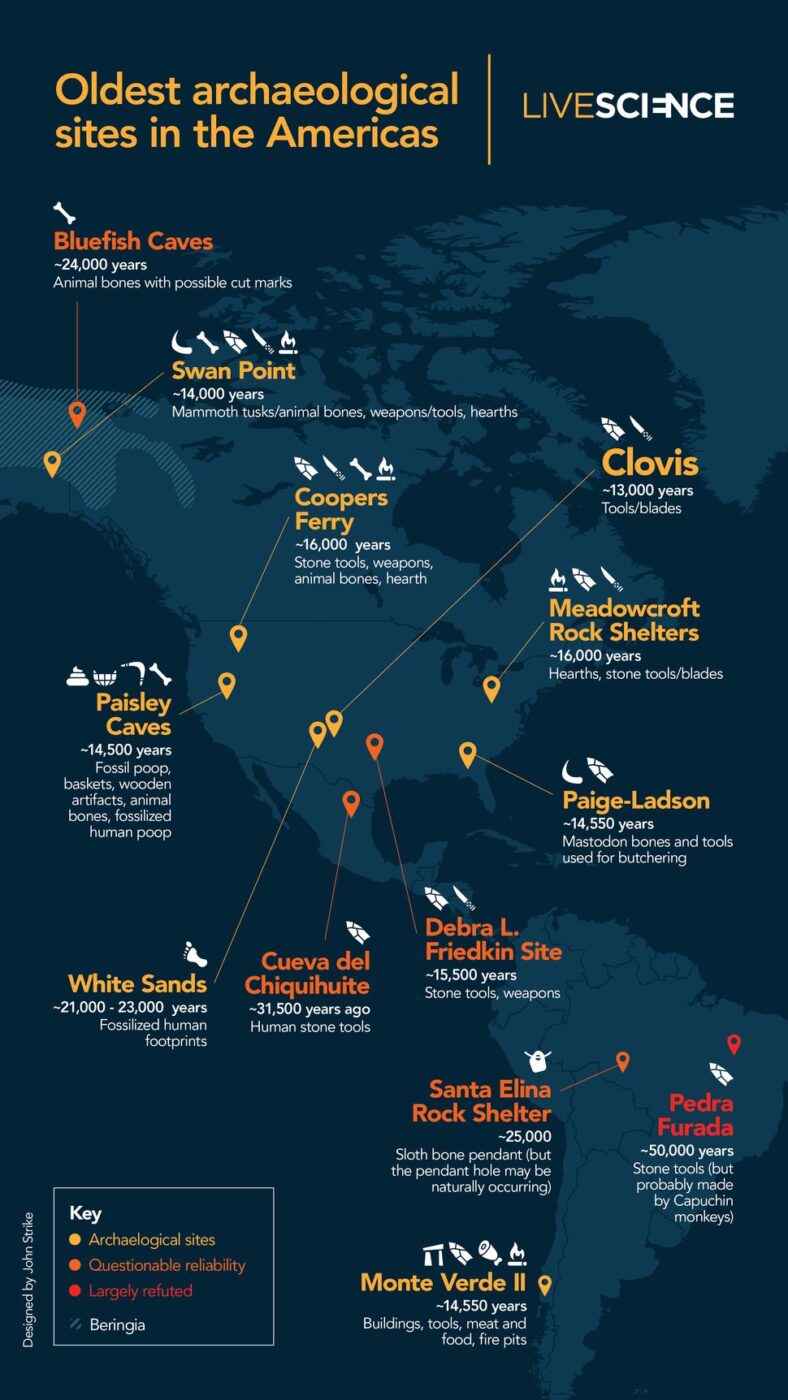
The older version of the story originated in the 1920s and 1930s, when Western archaeologists discovered sharp-edged, leaf-shaped stone spear points near Clovis, New Mexico. The people who made them, now dubbed the Clovis people, lived in North America between 13,000 and 12,700 years ago, based on a 2020 analysis of bone, charcoal and plant remains found at Clovis sites. At the time, it was thought that the Clovis traveled across Beringia and then moved through an ice-free corridor, or "a gap between the continental ice sheets," in what is now part of Alaska and Canada. However, new discoveries have turned back the clock on the first Americans' arrival. In 1976, researchers learned about the site of Monte Verde II in southern Chile, which radiocarbon dating showed was about 14,550 years old. It took decades for archaeologists to accept the dating of Monte Verde, but soon, other sites also pushed back the date of humans' arrival in the Americas.
|
|
|
The Paisley Caves in Oregon contain human coprolites, or fossilized poop, dating to about 14,500 years ago. Page-Ladson, a pre-Clovis site in Florida with stone tools and mastodon bones, dates to about 14,550 years ago. And Cooper's Ferry — a site that includes stone tools, animal bones and charcoal — dates to around 16,000 years ago. Then, in 2021, scientists announced much more ancient traces of human occupation: fossilized footprints in White Sands, New Mexico dating to between 21,000 and 23,000 years ago. Sites such as White Sands and Cooper's Ferry have big implications for how the first people arrived in the Americas. It's thought that the ice-free corridor through North America didn't fully open until about 13,800 years ago. So if humans were in the Americas long before then, they likely traveled there along the Pacific coast. That coastal journey could have been made by foot, by watercraft, or both. But no fossil or archaeological evidence of this journey has been unearthed.
|
|
|
|
Ideally, archaeologists would like to find more sites from all of these branches, especially any remains that could explain the genetics behind the people at White Sands between 23,000 and 21,000 years ago. Evidence of these long-lost people can be found in the remains of the animals they butchered, the charcoal they burned, the tools they crafted and the loved ones they buried. Local Indigenous Peoples' stories strongly suggest humans were in the area during the Ice Age Floods, but tangible scientific evidence is sparse and yet to be found in the area.
|
|
|
|
|
|
|
|
Do you have a question? We might have an answer!
Do you have a fact to share? We have a way to do that!
|
|
Members who want to do a short article, or describe a field trip location of interest, or describe a problem or some geologic site, can use our online form to submit a question or write-up to our technical committee for an answer or review before we post it on our Question Corner page.
|
|
|
|
|
|
|
|
|
The Puget Lobe will meet November 6, 2023 at 7:00PM via Zoom (https://us02web.zoom.us/j/82985244730) for Scott Burns to present “Ice Age Floods throughout the Quaternary. Don’t forget the older ones.” Keyword is the “older ones” – older than our “recent Fraser” Missoula Floods (18Kya-15Kya). Scott will tell you how to identify the deposits.
|
|
|
|
|
While J Harlen Bretz was exploring the Scablands with his grad students, Joseph Pardee was quietly amassing convincing data about the existence of Glacial Lake Missoula. Pardee’s work ultimately led to acceptance of Bretz’ theory of catastrophic outburst flooding as an important tool in the shaping of our world. Come hear Bill Burgel in person discuss JT Pardee’s critical role in the evolution of the science of geology! This presentation is In-Person Only on Thursday, October 19, 2023 at 7:00PM, at Tualatin Heritage Center, 8700 SW Sweek Drive, Tualatin, OR 97062
|
|
|
|
|
|
|
|
|
|
Non-members of IAFI have been increasingly taking advantage of our trust-based Free Shipping for Members. So we'll be increasing the IAFI Store prices by 10% for non-members beginning in January 2024, but Members will continue to get Free Shipping and a 10% discount off their Cart total.
|
|
Rather than impose a Member Login requirement we'll be sending out a coupon code that members can use for their 10% Off and Free Shipping. We'll see how this works out and make adjustments as needed to keep Store prices low for our Members.
|
|
|
|
|
|
THANK YOU IAFI MEMBER SUPPORTERS
|
Every member at every membership level is vital to IAFI’s continued success. Your support helps us meet our mission of providing the Ice Age Floods story to the public and continuing our work on the Ice Age Floods National Geologic Trail. Every gift counts, no matter the size. Thank you for making the IAFI what it is today and for helping shape it for the future.
|
|
|
|
|
|
Ice Age Floods Institute (IAFI) is a 501(c)(3) tax-exempt, non-profit educational organization (EIN 91-1658221), founded in 1995 and recognized as an official authority on the Ice Age Floods, providing accurate, scientific-based advice to members and the public. We were instrumental in 2009 Federal legislation authorizing National Park Service designation of the
Ice Age Floods National Geologic Trail (IAFNGT).
|
|
|
|
|
|
|
|
|