|
|
|
|
|
|
June Jamboree - 2024 IAFI Member Extravaganza
Hosted June 6-June 8 in Spokane
by the Cheney-Spokane Chapter
|
|
|
|
Last year, the IAFI Puget Lobe Chapter embarked on an expanded multi-day format for the annual IAFI field trip at Dry Falls State Park within the Grand Coulee The response was far beyond expectations, with over a hundred participants and rave reviews.
|
|
June 6-8, 2024, IAFI Cheney-Spokane Chapter plans to host an equally interesting and educational "June Jamboree" IAFI Member Meeting, in the Spokane Valley area north of the classic Channeled Scabland. We will explore a wide range of classic and historic sites in the most energetic floods areas near the source, before they dispersed down the channeled scablands and coulees.
|
|
|
|
|
|
A summary for our members and other interested people
By Gary Ford, IAFI President, January 12, 2024
|
This is our 7th year preparing a Year-in-Review report for you, our members. We appreciate your continued support, friendship and membership.
|
INSTITUTE MEMBERSHIP
Our members provide most of our support and much of the reason for the various materials, activities and events we provide. We started in 1996 with 11 members and at the end of 2023, as we continue to recover from the pandemic, we have 648 members (489 memberships) from 20 states, British Columbia, Canada and Germany.
|
ANNUAL MEMBERSHIP MEETING
This year we had our first annual membership meeting and field trip since the pandemic started back in 2020. It was sponsored by the Puget Lobe Chapter with major assistance from the Lower Grand Coulee Chapter and was held in the Sun Lakes State Park area. Click here for a summary of the event.
|
INSTITUTE BOARD PROJECTS
IAFI work activities occur at both the Institute Board of Director and Chapter levels. Projects at the Institute board level generally benefit more than one chapter or do work that all chapters might not be able to do by themselves. Listed below are some of the recent projects the Institute Board of Directors has worked on.
Education Committee is developing three 20-minute 4th grade level floods videos.
Membership Committee is developing a speakers catalog for member programs. A new membership system has been developed to better serve our members.
Trail Advocacy Committee works closely with the Ice Age Floods National Geologic Trail Program Manager on Trail development projects, such as three National Park Service sponsored Teacher Workshops this year.
Website and Newsletter: Our website (iafi.org) and Pleistocene Post quarterly newsletters feature fresh and stimulating news, events and general information.
|
2023 CHAPTER PROGRAMS
A key part of the IAFI mission is outreach to inform and educate the public about the Ice Age Floods and their long-lasting impact on our area. Local chapter programs, lectures, field trips and hikes are possibly the most effective way we meet this challenge.
Lectures - Our chapters offered 50 in-person hybrid presentations attended by over 1642 people, with many more viewers on YouTube.
Field Trips - Our chapters conducted 21 field trips for 586 attendees.
Hikes - Our chapters sponsored 13 hikes for 163 attendees.
|
PRESENTATIONS TO SCHOOL GROUPS AND SCIENTIFIC ORGANIZATIONS
Lake Lewis Chapter helped with education programs at The Coyote Canyon Mammoth Site (MCBONES) near Kennewick, exposing 1853 adults and 2242 kids to the stories of MCBONES' Coyote Canyon Mammoth Site and the Ice Age Flood.
Cheney-Spokane Chapter gave classroom and program talks to 451 students.
Glacial Lake Missoula Chapter helped Bozeman Science Camp with classroom activities and a field trip highlighting modern day Glacial Lake Missoula impacts.
Palouse Falls Chapter hosted lectures and tours for the Geological Society of Oregon Country, and an information booth at a Colton School STEAM night.
Lower Grand Coulee Chapter helped at the Dry Falls Ice Age Floods Fest.
|
CHAPTER PRESENTATIONS AT COMMUNITY EVENTS
Cheney-Spokane Chapter hosted booths at the Spokane Outdoor Expo and the Blue Waters Bluegrass Festival in Medical Lake, WA.
Glacial Lake Missoula Chapter gave Glacial Lake Missoula presentations and tours for Five Valleys Land Trust and Wildlife Film Festival film-makers.
Columbia River Gorge Chapter gave Floods presentations to Polish and German Marshall Fund delegations, led field trips for Bingen-White Salmon Rotary and Skyline Health, and recorded a Floods audio for the Lyle Cherry Orchard Trail.
Lower Grand Coulee Chapter hosted a booth at the Quincy Farmer Consumer Awareness Day with IAFI talks, tours, videos and information displays.
Palouse Falls Chapter led a tour at the Sandhill Crane Festival and hosted booths at both the Wheatland Fair and the Palouse Empire Fair.
Wenatchee Chapter participated in FCAD Farmer Consumer Awareness Days in Quincy; and presented at a Master Gardener Conference,
|
CHAPTER MEMBERSHIP APPRECIATION EVENTS
Our members are an essential part of our organization. Indeed, we would not exist without them. Listed below are some of activities chapters conducted to show their appreciation for their members.
Palouse Falls – A picnic at Lyons Ferry, short hike and car caravan.
Cheney-Spokane – A picnic and hikes at Camp Caro, Spokane Valley.
Coeur du Deluge - A Sagle Peninsula member appreciation field trip and picnic lunch.
|
PARTNERSHIPS AND COLLABORATION WITH OTHER ORGANIZATIONS
We work with other organizations to share resources and knowledge. Listed below are some of the organizations we have worked with.
Wenatchee – Wenatchee Valley Museum and Cultural Center, Port of Quincy, Othello Sandhill Crane Festival
Coeur Du Deluge – Idaho Master Naturalist Program
Lake Lewis – MCBONES Mammoth Site, Friends of Badger Mountain, Benton County Parks, The Hanford Reach Interpretative Center, Visit Tri-Cities, East Benton County Historical Museum, Franklin County Historical Museum
Cheney-Spokane – Spokane Riverfront Park board, Ice Age Floods Playground; VISIT Spokane
Palouse Falls – Whitman County Library, Lower Columbia Libraries, Lacrosse Community Pride, Sandhill Crane Festival
Lower Columbia – Tualatin Heritage Center, City of Tualatin, Tualatin Chamber of Commerce, Tualatin Ice Age Foundation, Friends of Vista House
Columbia River Gorge – Oregon Master Naturalist Program, Columbia Gorge Discovery Center, Vista House, Friends of the Columbia Gorge
Glacial Lake Missoula – Montana Natural History Center
Lower Grand Coulee – Coulee Corridor Consortium-Coulee Corridor National Scenic Byway; Coulee Corridor Area State Parks; Columbia Basin Trails Association, Soap Lake Conservatory.
|
INSTITUTE FINANCES
The IAFI is a non-profit organization whose main sources of income are membership dues, donations, field trips and IAFI Store sales. Funds are used primarily for existing and new educational programs to relate the Floods story.
|
WE WELCOME AND APPRECIATE YOUR HELP!
While we have over six hundred members, most of the work is done by a small number of institute and chapter leader volunteers. We are always looking for people willing to work with us to help develop and conduct chapter programs. If you think you might be interested, please contact your chapter president or board members. All help, both small and large, is greatly honored and appreciated.
|
|
|
|
|
|
Explore the Ice Age Floods ... and More
|
Places to Go, Things to See and Do
|
|
|
|
|
|
|
|
|
|
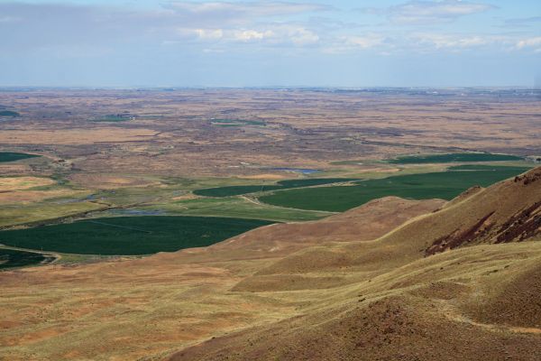
Saddle Mountain is an asymmetrical anticline of the Yakima Folds which starts south of Othello, WA and extends west across the Columbia River. During the last glacial period, the diverted Columbia River worked its way south, west of Othello through the Drumheller Channels to the mountain and then flowed west along its base to its preflood location at Sentinel Gap. Periodic Missoula Floods roared down the Drumheller Channels and crashed head on, undercutting the north side of the mountain and then diverting around both ends of it. This undercutting along with tilted basalt layers and intersedimentary beds led to multiple landslides creating the Corfu Landslide Complex. At least one of the landslides extended to the top of the ridge and created the “saddle” that gives the mountain its name.
|
|
|
by Lloyd Stoess, President, IAFI-Palouse Falls Chapter
|
|
|
Most people don’t know that the top of the mountain is accessible by a road from the south side. From SH 24 at MP 60.1, head north. At the “T” near the top, turn right and continue to the parking area at the turnaround. Walk east a short distance and you arrive at the saddle. To the north you have a great view of the Drumheller Channels, the Corfu Landslide Complex, and the course of the diverted Columbia River which now contains the underfit Crab Creek. To the south is the Hanford Reach area.
|
Along the ridge on the south side of the road there are several concrete foundations. From 1955 to 1962, these were armed with Ajax and Hercules missiles ready to be launched at any enemy attack on Hanford.
|
I met a worker from Boeing on one of my visits. He takes a trip to this isolated place twice a year to spend a weekend away from the hustle and bustle, noise, and light pollution of the big city. The top of the mountain is certainly a place of solitude and provides a great bird’s eye view of this part of our flood story.
|
|
I am tentatively planning a Sandhills Crane bus tour this March to include this stop. Our chapter is also in the early stages of an extended weekend event that would include it.
|
|
|
|
|
|
Views from Palisades and High Bridge Parks
|
|
|
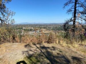
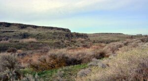
Palisades Park
The Palisades Conservation Area encompasses 700 acres and provides a spectacular overview of the main Missoula floodpath through the Spokane Valley, which was then occupied by glacial Lake Columbia. The Park is at the top of a basalt bench historically referred to as rimrock and characterized by large boulders of fractured basalt undermined by the megaflood which widened Spokane Valley. In the far distance, well above the flood debacle, is Mt Spokane, highest peak in the Selkirk Range.
|
|
|
|
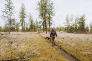
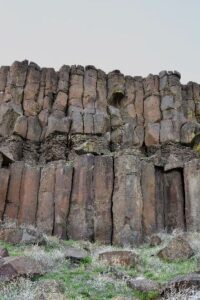
This park’s trail system consists of a mixture of converted road bed and single trackways meandering through Ponderosa pines interspersed between flowered meadows, including seasonal wetlands, scour pools and isolated outcrops of columnar basalts, typical of megaflood erosion found in the Channeled Scabland.
|
|
|
|
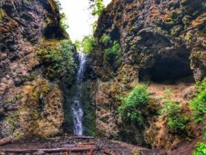
If you stick to the upper trail on top of the bench emanating westward along Rimrock Drive, you will see spectacular wildflower blooms in the spring and little elevation gain. For the more adventurous hiker, head south along Rimrock Drive and drop down 200 feet to Indian Canyon Mystic Falls, which cut into and expose pillow basalt found below the rimrock.
|
|
|
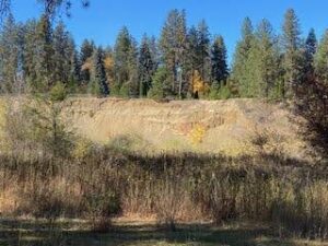
Highbridge Park
An exceptional cliff exposure of the Missoula megaflood deposit, which once filled the Spokane Valley, can be viewed along Latah Creek near the confluence with the Spokane River.
|
|
|
|
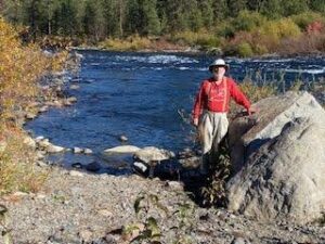
This exposure can be viewed from an extensive gravel bar within Highbridge Park that can be reached by a short hike along a dirt road trail from the parking lot near the intersection of Riverside and Clarke Avenues. You can see within this 60-foot exposure of a cross-bedded megaflood deposit, visible channeling, gravel lenses (pinching in and out of channels), scour depressions and a big boulder filled channel just below the terraced surface. A small exposure of Mt. Mazama ash dating back to 7,700 years ago occurs at the top of this terrace marking the past elevation of Latah Creek. Standing at the confluence is Mike McCollum, who provided much helpful info about the flood features.
|
|
|
|
Another reason to visit this site is that archaeologists excavated and recovered anthropological evidence that this flood gravel bar was a very important fishing site and gathering place for indigenous people for at least 8,000 years. We invite all the IAFI members to join us in early June for another multi-day Annual Fieldtrip Jamboree and we will even include these two parks in our agenda. So those of you who are interested in seeing the evidence suggesting that the Spokane Valley was carved out by the Missoula megafloods might want to sign up soon, space is limited. Who knows, but maybe our region’s flood history may not be that different from those of you residing in the Channeled Scablands after all.
|
|
|
|
|
This article is a collaboration between IAFI Cheney-Spokane board members Dr. Linda McCollum, President; Jim Fox, Vice President; and Don Chadbourne Treasurer
|
|
|
|
|
|
|
|
|
|
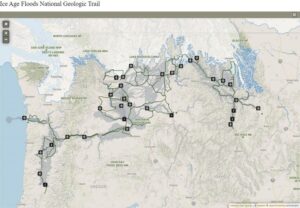
Hello from the Trail. Congress created Ice Age Floods National Geologic Trail to educate visitors on the story of massive flooding towards the end of the last Ice Age in the Northwest. Its primary function is to grow connections between like-minded organizations and to increase public awareness and understanding across the four-state region.
|
|
|
|
The Trail made progress during 2023, and some of the highlights include the development of our web-based interactive map, including an additional 70 flood site locations in our GIS database. Last year, we also joined fellow floods enthusiasts at multiple events, including the Ice Age Floods Institute's annual member meeting, the US Geological Society of America's Penrose conference on glacial lake outburst floods, and numerous festivals and trade shows across the region.
|
|
2024 is shaping up to be another great year of sharing the story of the floods. We are looking forward to several trade show events in the Spokane area this winter, along with the Sandhill Crane Festival in March. This would be a great time to try out the NPS App.
|
|
|
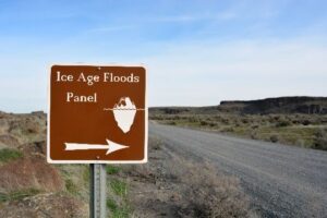
The Columbia Nation Wildlife Refuge includes Drumheller Channels Nation Natural Landmark, and the NPS App can help you navigate this area to features important to the Ice Age floods story. There are many unique places along the Ice Age Floods National Geologic Trail, and the Drumheller Channels are one of my favorites. I've had the chance to travel through sections of this magnificent landscape a couple of times and always find something new. Drumheller Channels are, for sure, part of the Channeled Scablands of Central and Eastern Washington State.
|
|
|
|
This butte and basin landscape had as much as 400 feet of sedimentary and volcanic basement rocks torn away by the Missoula Floods, creating nine massive channels. Be sure to think about coming out to the Othello Sandhill Crane Festival March 22-24, 2024, where you can have some fun celebrating the return of 35,000 sandhill cranes and see the landscape that was forever changed by the Ice Age floods. As always, see you out on the Trail.
|
|
|
|
|
|
Justin Radford is Program Manager for the Ice Age Floods National Geologic Trail
|
|
|
|
|
|
|
Interesting articles and answers to questions about things related to the Ice Age Floods
|
|
Use our online form to submit an article or question to our Question Corner page
|
|
|
|
|
|
|
|
|
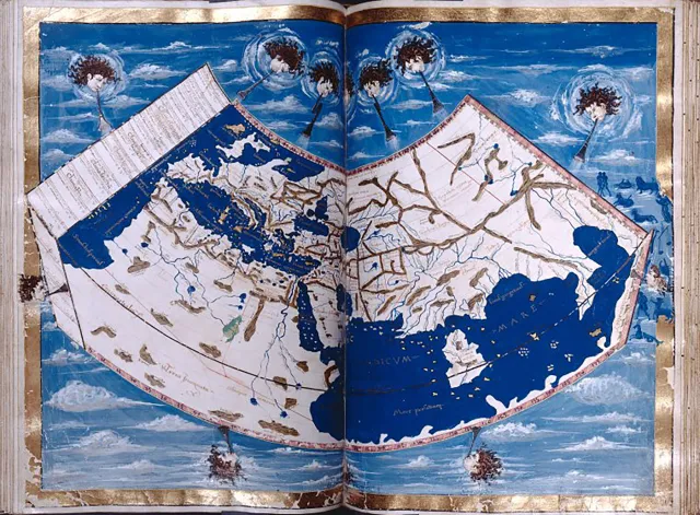
Many of history’s major breakthroughs were made by great thinkers standing on the shoulders of other intellectual giants, and Ptolemy’s Geographia, which builds on the scientific advancements of ancient Greek scholars, is no exception.
|
The ancient Greeks were particularly skilled at understanding the world around them. By the fifth century BCE, the famous mathematician Pythagoras understood that the Earth was round, and it wasn’t long before Eratosthenes, another Greek scholar, accurately calculated the planet’s circumference.
|
|
Centuries later, the Egyptian Greek scholar Ptolemy channeled all these scientific advancements into his masterwork, a collection of maps known as Geographia. Created around the year 150 CE, the eight-volume atlas served as a blueprint for mapmaking during the time of the Roman Empire.
|
|
|
|
|
|
Ptolemy detailed the process of projecting a globe-shaped object onto a two-dimensional map, and pinpointed some 8,000 locations throughout Eurasia and northern Africa. He borrowed the concept of longitude and latitude from his mapmaking contemporary Marinus of Tyre, and built on it to make his own lasting contributions to cartography. Ptolemy’s work fueled many of the maps to come during the Islamic Golden Age and Europe’s Renaissance era.
|
|
|
|
|
|
|
|
If you have been following Professor Nick Zentner (CWU) on YouTube, you may know that one of the treasures he has uncovered with the help of collaborators are the Bretz journals from field research done from 1919 through 1929. After Bretz's death in 1981, his family donated his papers to the University of Chicago Library and though they were available to the public, access was very limited. Recently Professor Zentner was able to obtain whole-hearted permission from Bretz's family to share them more widely. Because of this, scans have been made of the journals and PDF's are now available on Nick's website for viewing/downloading.
|
|
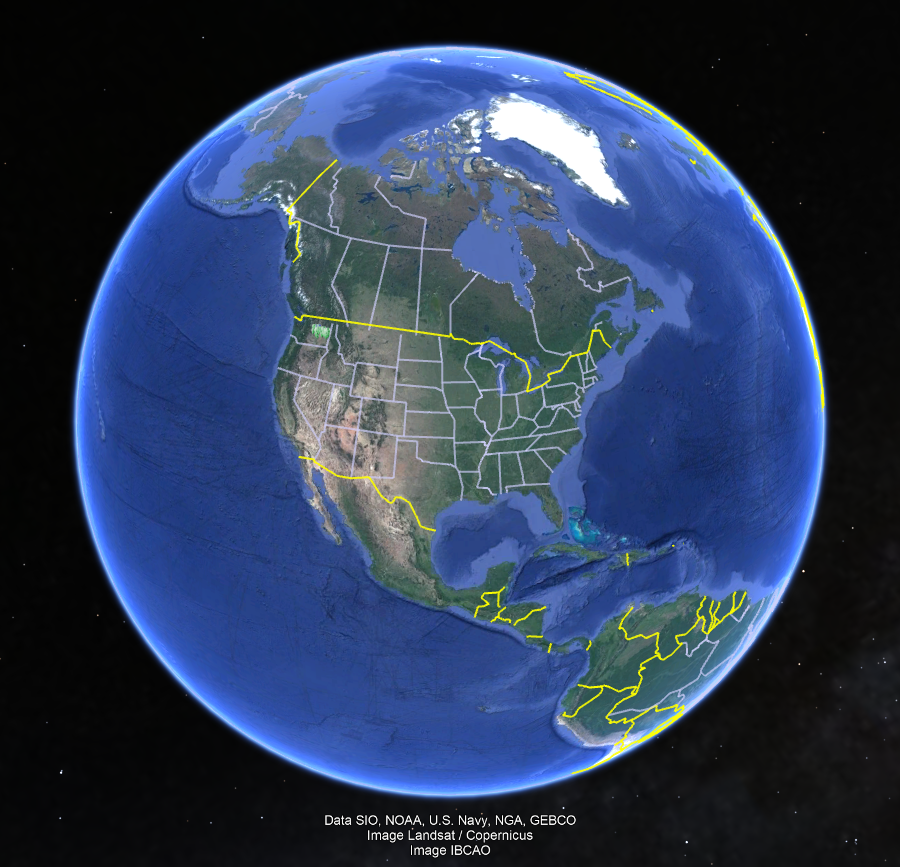
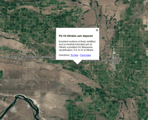
In November, 2023 Nick began a new series called "Ice Age Floods A to Z." (The videos are recorded and can be viewed on YouTube.) During session I, Nick invited viewer Glenn Cruickshank (Liberty Lake, WA) to share about how to use Google Earth to view the travels of J Harlen Bretz based on his field journals. Glenn had the idea that he could transfer Bretz journal locations to Google Earth; in doing so he has created files for each of the Bretz's years in the Northwest!
|
|
|
Using Google Earth with Glenn's files, a marker appears on the map for each location that Bretz visited during a particular year and includes a snippet of his notes. The map points are all identified by year and by journal page. Not only can you zoom into the satellite images, but you can also use the 'Street View' feature to see various outcrops along roads that still exist today.
|
|
|
|
Google Earth is a free program and can be used on the web, or as an app you can download for a mobile phone, tablet, or your computer (PC, Mac, or Linux). It is similar to Google Maps, but with many more capabilities. If you are just getting started with it, you may want to check out one of the many beginner tutorials on YouTube.
|
All of Glenn's work has been linked on Nick Zentner's website. Glenn has included step by step instructions on how to load the Bretz Files into Google Earth from Nick's site. Using the journals and Glenn's Google Earth files, you can follow along with Bretz's field travels year by year.
|
|
|
|
|
|
|
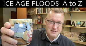
|
Our good friend Professor Nick Zentner (Central Washington University) recently started a new series on his YouTube channel called ICE AGE FLOODS A-Z. It is being live-streamed Thursday at 12:00 pm and every Sunday at 9:00 am Pacific Time.
|
|
Sessions A-H (streamed and recorded in November and December) have set the stage leading up to the time of J Harlen Bretz. They cover Bretz's predecessors and mentors (Israel C. Russell, Bailey Willis) and some of Bretz's journey from starting out as a biology major and later becoming a geologist, to the chance meeting that propelled him to come to the Northwest.
|
|
Special guests have included Jerome Lesemann, Skye Cooley, Joel Gombiner, and Glenn Cruickshank. The series is also being recorded so that it can be watched anytime.
|
|
|
|
|
|
|
|
- January 18 @ 7:00PM: Dr. Scott Burns – Ancient Ice Age Floods Before the Missoula Floods, Lower Columbia Chapter
- February 13 @ 7:00PM: Bill Burgel - JT Pardee and the Lake He Discovered, Wenatchee Valley Erratics Chapter
- February 20 @ 6:00PM: Dr. Linda McCollum - Cheney at the Head of Channeled Scablands, Cheney-Spokane Chapter
- February 20 @ 7:00PM: Dr. Bruce Bjornstad - Ice Age Floodscapes of the Pacific Northwest, Lake Lewis Chapter
- February 22 @ 2:00PM: Geologist Michael Hamilton - The Spokane Aquifer: Legacy of the Ice Age Floods, Cheney-Spokane Chapter
- February 26 @ 6:00PM: Dr. Gary Ford - PNW in Brief: The Most Recent Ice Age Floods, Cheney-Spokane Chapter
- February 28 @ 6:00PM: Dr. Paul Lindholdt - Imagined History: Paddling Lake Missoula, Cheney-Spokane Chapter
- March 18 @ 7:00PM: Dr. Ralph Haugerrud - Wasting of the Southern Margins of the Cordilleran Ice Sheet, Puget Lobe Chapter
- June 6-June 8: June Jamboree - Annual IAFI Membership Meeting in Spokane, WA (check iafi.org regularly for updates and more information)
|
|
|
|
|
|
|
A personal note of explanation from Patty Hurd, our Store Manager
|
I regret to announce that the prices on some store items must be increased at the end of January due to the increased cost of merchandise, steadily increasing shipping costs, non-members taking advantage of our "free member shipping" and competition from the likes of Amazon for many non-proprietary items.
|
The prices of all books, maps/posters and our DVD offerings will increase approximately $1.00, and baseball hats will increase to $18.00. Decals and art prints will remain the same price. We decided against our previously announced plan to use 10% member discounts as that would have created a nightmare for bookkeeping and making change at live events.
|
I want to assure members that this step is not taken lightly. There is no Store overhead, all profits accrue to the Ice Age Floods Institute. Store expenses are solely for merchandise re-stocking, postage and shipping fees, sales tax, PayPal and Woo Commerce fees, and occasional purchases of items for inventory storage at no cost at my home. I am a volunteer and the only store "personnel", I receive no compensation and I try mightily to keep expenses down as much as possible.
|
|
Please rest assured that every cent is spent to increase our members ability to explore and discover our incredible Floods country. Things in this newsletter like chapter gatherings, field trips, guest speakers, improved trail signage and work on the trail itself, increased educational offerings for adults and school children alike, interactive guides and maps for people exploring and sightseeing in our area, show that IAFI stewards its funds wisely and well. The store is set up to support IAFI, and will continue to do so while keeping costs down and our resources current and accurate and in-stock. Thank you for supporting the Ice Age Floods Institute and shopping at the Ice Age Floods Institute Store.
|
|
|
|
THANK YOU IAFI MEMBER SUPPORTERS
|
Every member at every membership level is vital to IAFI’s continued success. Your support helps us meet our mission of sharing the Ice Age Floods story with the public and continuing our work on the Ice Age Floods National Geologic Trail. Every gift counts, no matter the size. Thank you for making the IAFI what it is today and for helping shape it for the future.
|
|
|
|
|
|
Don & Christine Barnes
Gary Rudgers
Jan Strobeck
Harriet Van Wyck
Jeff Schmelzer
|
William Buckley
Greg Whitehead
Randy Roth
|
|
Paul Osmanson
Lindsay Henning
Sue & Tom Ring Billings
Gary Marlow
Mary R. Lewis
Don & Christine Barnes
Susan D. Freiberg
|
|
Jay Beach
Dean Wheelon
Donald Burnham
Brian McClure
Michael Teegarden
Donald Chadbourne
Ray Redd
Jena Gilman
|
|
|
|
|
|
John & Dian Adams
Dorene Bendickson
Nancy J. Biggerstaff
Sandra (family) Bowman
Van Brinkerhoff
Russell & Sue Carlisle
David Carstens
Kristen & Josie Chapin
Cynde & Alan Chatham
Catherine & Daniel Speth Clemens
Yvonne & Liam Turnmire Daley
Dave Daugharty
Steve & Mary Davis
William & Julie Engstrom
Gary & Barbara Ford
Richard & Judy Hademan-Frith
Daniel Fritz
Ron & Carolyn Gooley
Carrie Gordon
Erika & Curtis Hennings
|
|
Jeff Herrmann
Patrick Horgan
Gary Horinek
Chuck Hosack
Douglas Huber
Paul, Nancy, John, Olivia, Clara & Uriah Hutton
Jim Jacks
Pat Jamieson
Bruce Jividen
|
Antonio & Jean Snider Jover
Alice & Rob Bowie Kaseberg
Dick Kleinknecht
George Last
Ron & Denise Zembryki Mamajek
Clark & Joyce Markell
Glenn Marquardt
Alex & Linda McGregor
Mary & John Bolles McGregor
Mark Mease
|
|
Jack & Anne Middleton
P. Erik & Kari Angell-Petersen Mikkelsen
Michael G. Millsap
John Robert & Sharon E. Moody
Chris & Carla Chiotti Murray
Lori & Dave Obbie
Shawn Pare
Laird & Shawna Parry
Nancy & Dennis Rieger
Ron & Kathy Stefan Shuler
Roger Stevenson
Tom A. Stokes
Gerald & Nancy Tays
Eric Thorsen
Jim & Ann Warrington Trivelpiece
Robert Vallem
Richard Walton
Steven L. & Lynn Washington
Krystyna Wolniakowski
|
|
|
|
2023 Major Donors (>$100)
|
|
|
John & Mary Hartman
Gary Rudgers
Mary R. Lewis
Brian G. Holmes
Susan Langsley
Melanie & Bob Bell Gibbs
|
|
Alex & Linda McGregor
Ronald Cocchiarella
John Perkins
Lola Helen Kemp
Eric Thorsen
|
|
Lindsay Henning
Sandra Jackson
Pam Cahn
Craig Smithson
Laird & Shawna Parry
|
|
|
|
|
|
|
We hope you enjoy our newsletter and we appreciate any questions, comments or corrections by email to our Webmaster/Newsletter Editor: Lloyd DeKay
|
|
|
|
Ice Age Floods Institute (IAFI) is a 501(c)(3) tax-exempt, non-profit educational organization (EIN 91-1658221), founded in 1995 and recognized as an official authority on the Ice Age Floods, providing accurate, scientific-based advice to members and the public. We were instrumental in 2009 Federal legislation authorizing National Park Service designation of the
Ice Age Floods National Geologic Trail (IAFNGT).
|
|
|
|
|
|
|
|
|