|
|
|
|
|
|
|
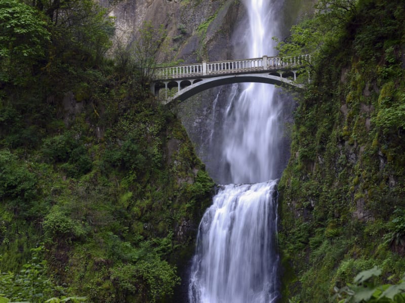
In September 2021 my wife and I took a trip to see what was new along the Ice Age Floods National Geologic Trail and visit some places we did not make it to in our very first trip in 2004.
|
|
The IAFI chapter brochures were very helpful in learning what there was to see in each area. We also remembered a preview of the National Parks Service unigrid map brochure that will come out hopefully later this year, so be sure and get one when it debuts. The other excellent tool was the online interactive map on the Ice Age Floods Institute website (https://iafi.org/floodscapes/), where you can click on a spot and see a photo and description of the site. All are great planning tools.
|
|
|
|
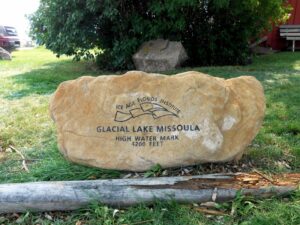
We drove to Missoula, Montana and stayed there a couple of days as we made day trips. Our first one was to Ovando to see a granite glacial erratic that the Glacial Lake Missoula Chapter had etched and placed at the high-water line. You will find it at Trixi’s Antler Saloon which is a nice place to grab a bite for lunch. The chapter has a number of these high water markers placed already and have more planned to show the full extent of Glacial Lake Missoula. Unfortunately, due to the smoke from the wildfires we were not able to go to Hamilton to see the 8-ton granite erratics outside Ravaili Museum with four interpretive signs outside and additional displays inside.
|
We drove up to the Paradise Center in Paradise, Montana. We had been there before in 2016 for the fall IAFI field trip and they were just dreaming of what the old Paradise Elementary School could become. They have done a wonderful job of making that dream come true. It was one of our favorite spots on this trip. They have dedicated an entire room to the Ice Age Floods story where an extremely accurate 3-D map of Glacial Lake Missoula has lights installed so you can push a button to light up the edge of the ice lobe and other features. Besides information about the Ice Age Floods, the Center also has wonderful displays about the trains & train yard that used to be in Paradise and the history of the Paradise Elementary School.
|
|
We went to the Natural History Museum in Missoula and enjoyed the panels and video which told the Lake Missoula Floods story and also about Joseph Pardee, a very important pioneer in solving the mystery of these Floods. This museum also displays an amazing amount of taxidermy showing the wildlife and birds in the region.
|
|
|
|
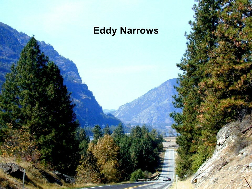
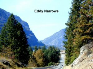
On our way up to Sandpoint, Idaho we passed through Eddy Narrows. Glacial Lake Missoula drained through this canyon going 80 mph leaving horizontal marks high up on the walls. Previously these were thought to be glacial striations, but Pardee speculated that these marks were from huge boulders as they shot through the Narrows. The Narrows is long with few places you can pull over on Highway 200, so it can be hard to really appreciate its scope. We got a good view from the Koo-Koo-Sint Bighorn Sheep Viewing Interpretive Site which has several interpretive signs that talk about the sheep and the geology of the Clark Fork River Valley.
|
|
|
We then went over to Farragut State Park at the southern tip of Lake Pend Oreille to view the beginning of the outburst plain that formed the Rathdrum/Spokane Valley aquifer. Across Lake Pend Oreille is Green Monarch Ridge; the terminus of the Purcell Trench which held the 4,000 ft. ice dam that carved the steep walls. The display at the museum has several interpretive panels.
|
|
|
|
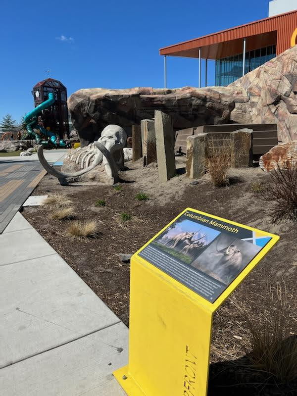
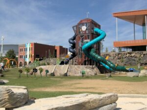
The next day we met Consuelo Larrabee who gave us a personal tour of the 40,000 square foot Ice Age Floods Playground in Riverfront Park in Spokane, Washington. She and Melanie Bell, the president of the Cheney-Spokane chapter, did an enormous amount of work as consultants on this fabulous, themed park. Kids can learn as they play on the three-story Columbian slide tower, Glacial Dam splash pad, log jam climber, an alluvial deposit fossil dig, and more. The park was filled with kids and the adults were enjoying it as much as the kids. We loved watching the excitement of a child as she saw the splash pad water fountains simulate the ice dam starting to rupture and then the cascade of water flooding over the manmade basalt rocks. Along the side of the building are actual basalt columns and the fossil dig led to many exciting discoveries by the children as they dug through the sand to reveal embedded replicas of fossils. Throughout the park are thoughtfully placed benches for people to sit and watch the fun going on around them. There are nine interpretive panels throughout the park adding a wonderful educational benefit to all the fun. This park will be quite a prize for years to come.
|
|
The next day we drove along Highway 262 to W. McManamon Road to the Drumheller Channels National Natural Landmark. This outlet from the Quincy Basin, with floodwaters going 65 mph eroded not just the topsoil but the underlying basalt which created dramatic channels, basins, potholes and buttes. The viewpoints along the drive had several interpretive panels talking about these wonderful vistas.
|
|
|
|
Since we live in Portland and this trip was to see places we had not recently seen, we skipped over the many wonderful places in the Columbia River Gorge, Willamette Valley & Tualatin. But for your trip, please check out the hundreds of beautiful and interesting sites to see in this region.
|
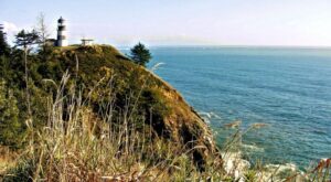
The last stop for this trip was Cape Disappointment. The Floods debris flushing out the mouth of the Columbia River added substantially to submarine Astoria Fan and sediment cores have shown that ocean currents carried some of this debris all the way down to Cape Mendocino, California. Although not visible from the surface, the Park display has a relief map that shows the Astoria Canyon and Fan. The mouth of the Columbia River area is known as the “Graveyard of the Pacific” because of the shifting sand bars that require a pilot to guide you into the mouth of the river. One display shows how many ships have floundered and sunk.
|
|
|
|
|
By Rick Thompson, President, Lower Columbia Chapter
|
|
|
|
|
|
|
|
|
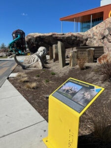
Permanent information panels have been installed in the Ice Age Floods Playground in Spokane’s Riverfront Park.
|
|
|
|
The panels briefly describe:
|
Fire: Basalt & Columnar Basalt
Ice: The Cordilleran Ice Sheet
Water: The Missoula Floods
Rhythmites & Varves
Erratics & Granite
Giant Current Dunes
Animals: Columbian Mammoths
Animal Fossils
|
The panels have a heavy duty permanent covering, impervious to weather & wanton destruction. They will add greatly to the experience of this special and very popular space.
|
|
The Ice Age Floods Playground is a spectacular addition to Spokane’s Riverfront Park that is well worth a visit for kids and adults alike.
|
|
|
|
|
|
|
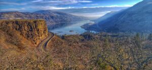
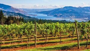
The Columbia River Gorge is an incredibly popular area to visit, and that’s for good reason, the setting is uniquely spectacular. The Gorge encompasses:
|
|
|
|
● Easily accessible ecozones that range through boreal conifer forests, oak woodlands, high desert grasslands and alpine environments in only 40 miles,
|
|
● Dazzling viewpoints and scenery, including beautiful waterfalls that cascade over the high basalt ramparts that bound the relatively narrow Gorge and the majestic Columbia River running through it,
|
|
● Mt. Adams, Mt. St. Helens and Mt. Hood, imposing snow-covered stratovolcanoes lying less than 40 miles north and south of the Gorge,
|
|
● Picturesque small towns that are bounded by extensive federally- and state-protected natural areas throughout the length of the Gorge,
|
|
● Abundant recreation opportunities including hiking, road/mountain biking, windsurfing and kiteboarding, whitewater kayaking and rafting, fishing, hunting, alpine/cross-country skiing and snowshoeing,
|
|
● Numerous award-winning wineries and breweries, restaurants and pubs, shops, galleries, museums, parks, hotels and campgrounds,
|
|
|
And all this is lying at the back doorstep of Portland, Oregon.
|
|
|
|
The Gorge is also a geologic wonderland, exposing stories about:
|
|
● The 40 million year history of the Columbia River,
|
|
● The series of massive Columbia River Basalt flows 18-12 million years ago,
|
|
● The rise of the Cascade Mountain Range since about 5 million years ago,
|
|
● The passage of numerous, up to 1000 feet deep Ice Age Floods that reshaped the Gorge 18-14 thousand years ago,
|
|
● Tectonic faulting and folding, landslides, earthquakes, forest fires, and
|
|
● The often intertwined lives and stories of the people who have lived here.
|
|
|
|
Of course, with all this bounty the area is also a robust tourist mecca, which can mean limited accommodations for summer crowds. Most attractions are easy to drive to, but bus tours and river cruises are also available. Due to the popularity, some of the iconic attractions now seasonally restrict vehicle access and require permits.
|
|
|
|
|
|
|
|
|
|
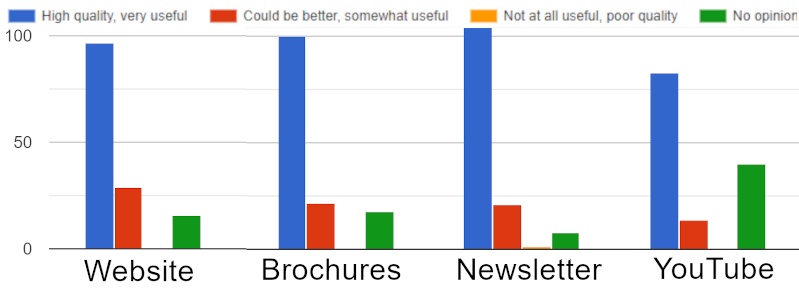
Earlier this year we sent out our first IAFI member survey. A big THANK YOU to the 154 members who responded, an outstanding 30% response rate. You're helping us see what we're doing right, understand where we can improve, and where we should direct our efforts.
|
Most of the responses affirm that we are doing a lot of things right at the national and chapter level to fulfill our Mission. “IAFI is committed to being a recognized advocate, educator, and marketer of the Ice Age floods experience as a significant international, natural and cultural heritage phenomenon.” We appreciate your confidence in our efforts and the fresh ideas you offered that are helping us think outside the box.
|
|
We are particularly pleased at your strong support for our field trips, website, chapter brochures, newsletters, public lectures and for the lecture recordings posted to YouTube for later viewing (22 new subscribers, 1,440 total views for 395 viewing hours just last month alone).
|
|
However, we are somewhat concerned to find that several members are not familiar with our YouTube channel, nor our online IAFI Store. Direct links to these features can be readily found upper right on our IAFI.org homepage. You might want to bookmark these:
|
- Our IAFI YouTube playlists include links to a large and growing number of chapter presentations, geology lectures, and other Floods-related video recordings.
- Our online IAFI Store offers a number of Floods-related items, including books, maps, our very popular chapter brochures, clothing, prints, posters and more.
|
As each chapter reviews their specific survey results and comments, you may see some changes and tweaking of the programs within your chapter. There were also suggestions for larger projects which will require action from the board and/or multiple chapters. These suggestions will be reviewed, discussed and prioritized at the IAFI board meeting in May. We will then present our plans for these ideas in the July Pleistocene Post, and will be looking for help from our members to bring them to fruition.
|
|
|
|
|
|
|
Ice Age Floods Fourth Grade Curriculum Development
|
|
One of the missions of the Ice Age Floods Institute is to educate young people about the Floods and the influence of the Floods on their lives today. The IAFI Educational Outreach Committee has contracted with the curriculum design firm The Inspired Classroom to produce engaging lesson materials to excite fourth-grade students from across the Northwest about the Ice Age Floods.
|
|

|
|
The curriculum will contain video footage narrated by experts and lesson plans for use by fourth grade teachers in Montana, Idaho, Washington and Oregon. The story, entitled “Scholars Trek on the Ice Age Floods Trail,” will begin with a flyover video of the trail, including Glacial Lake Missoula, the Clark Fork Ice Dam, the Rathdrum Prairie, Spokane Falls, the Channeled Scabland, Lake Lewis, the Columbia River Gorge, Lake Allison, and the deposition of the eroded sediment on the continental shelf at the mouth of the Columbia River.
|
|
|
Along the route, students will be introduced to the ways in which the Floods influence society today, including the influence of the Floods on the Spokane Aquifer and on railroad and highway routes across the Pacific Northwest.
|
|

|
Funding for the project will come from grants, the IAFI, and from private benefactors. The continued support of IAFI members through membership dues and donations helps fund projects like this.
|
The Education Committee is made up from a sampling of IAFI Board Members and Chapter Presidents from each state: Jim Shelden (Glacial Lake Missoula); Tony Lewis (Coeur du Deluge); Melanie Bell and Consuelo Larrabee (Cheney-Spokane); Gary Kleinknect (Lake Lewis) and Dale Lehman (Puget Lobe.) In the future, the Education Committee plans to work on curriculum materials for middle and high school students.
|
|
By Dale Lehman, 04/14/2022
|
|
|
|
|
|
|
|
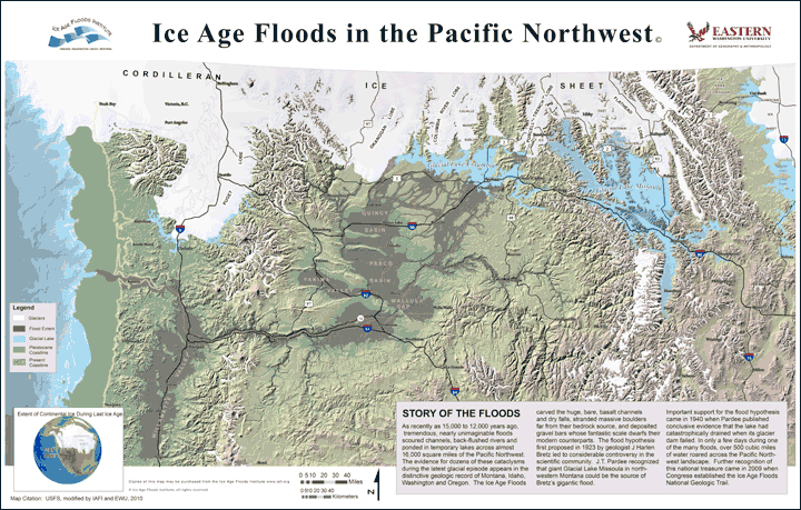
Click on the map to go to the Store item.
|
|
|
The IAFI Store is having a sale from April 15th through May 31st on three of its most popular items. All large (24" x 36") maps of "Ice Age Floods in the Pacific Northwest" will be priced at $17.50 each. The smaller 11" x 17" laminated version will be on sale for $12 and the unlaminated 11" x 17" paper version will be $10 during that period. The sale is limited to our stock on hand, so purchase before stocks run out.
|
|
|
|
|
|
|
|
|
|
|
|
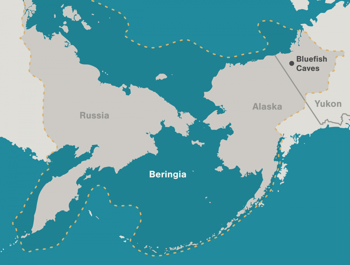
Archaeologists have long debated how and when people entered the Americas. Throughout the 20th century, the mainstream hypothesis was that the Clovis people were the first to pass into Alaska about 13,000 years ago.
|
|
Stemming from his excavations between 1977 and 1987 at the Bluefish Caves in northwestern Yukon, Jacques Cinq-Mars, a Canadian archaeologist, unearthed evidence that hunters were using the site some 24,000 years ago.
|
Lauriane Bourgeon, a French archaeologist, has spent much of her career re-examining and scrupulously dating the Bluefish Caves collection to clarify the history of the contentious site. Her research has shown that at least 15 bones from the Bluefish Caves were cut-marked by people as early as 23,500 years ago, confirming Cinq-Mars data.
|
|
|
|
|
|
|
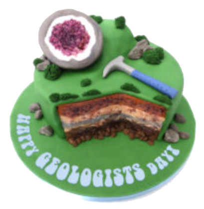
Geologists Day, a day dedicated to an underappreciated science, takes place on the first Sunday in April every year. Without geologists, we would know nothing about the over 4.5 billion year history of the earth. Geology is a science that studies the materials, natural features, and processes found on earth, as well as the history of all life that’s ever lived. Geologists around the world have made an enormous contribution to our way of life by discovering and developing our natural resources of minerals, hydrocarbons and water, by understanding the evolution of our planet and our solar system, by defining the evolution of life on Earth, by identifying the risks associated with natural hazards such as earthquakes, tsunamis and volcanic eruptions, and by the technological and innovation spin-offs derived from many branches of geoscience such as geophysics and geochemistry.
|
|
Geologists’ Day, itself, was actually the idea of a group of well-known Soviet geologists who established it in April, 1966. The day eventually made its way beyond the former Soviet Union and began to be celebrated by geologists, geophysicists and geochemists in various places in Europe, the United States and other countries around the world.
|
|
|
|
|

|
How to Celebrate Geologists’ Day
Held on the first Sunday in April, the celebration of Geologists’ Day can be fun for professional rock lovers and hobbyists alike! This day strives to help further the study of how the earth came to be. Geologists’ Day is all about learning the history of the earth, the geologists who studied the earth, and helping to inspire people out there to study geology.
|
Learn More About Geology
Give a nod to Geologists’ Day by learning a bit about what the discipline of geology is and how it works. Digging in rocks, observing maps, and studying how they all came to be is what a geologist’s job is all about.
|
Those who are even more interested might take the time to join a few online classes to further their studies. Take a look into the history of geologists, what they believed about the earth at the time they lived. If it turns out there’s an inner rock-lover in there, just waiting to get out, why not go for a degree while you’re at it?!
|
Share Geology Day with Friends
Show appreciation for the studies of geologists by sharing this holiday with friends and family. Go big by throwing a geology party, or keep it small by simply gifting friends or coworkers with a small stone or rock as a token of the day. Whatever method is chosen, just the acknowledgment of this day is a step in the right direction toward appreciating the earth and its scientists!
|
|
|
|
|
|
|
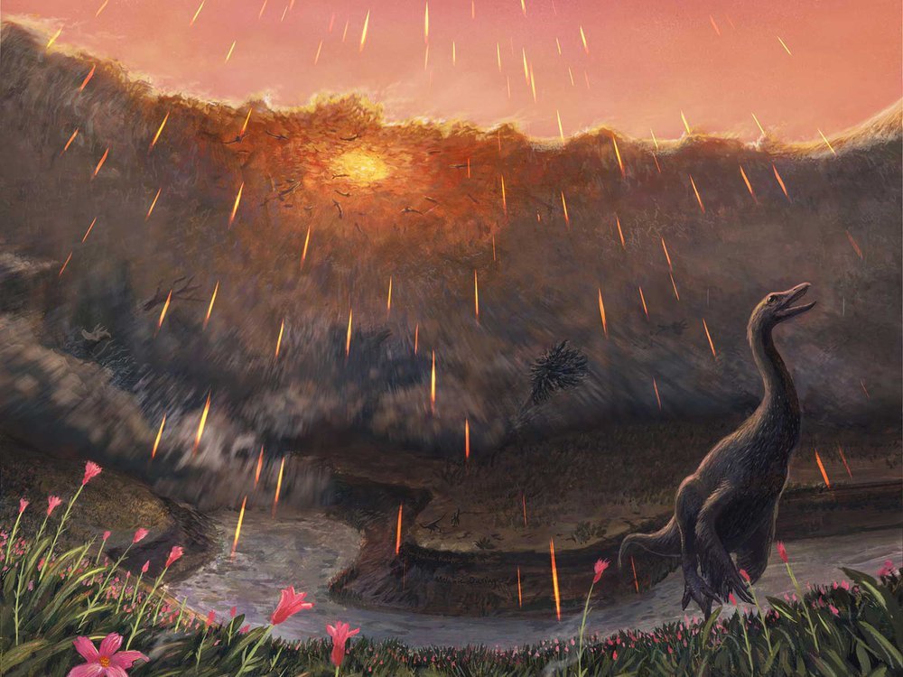
Spring may have been when a roughly seven-mile-wide asteroid struck the Earth, immediately triggering the mass extinction that would wipe out 76 percent of known species. That key piece of timing doesn’t come from dinosaurs, but from the fish that swam in the waters dinosaurs drank from. By studying the fossil bones of these fish and comparing them to their modern counterparts, Vrije Universiteit Amsterdam paleontologist Melanie During and colleagues have come to the conclusion that the impact that ended the Age of Dinosaurs most likely occurred in the spring.
|
|
During warmer months when food was plentiful, the ancient fish grew and added more bone tissue just as their modern relatives do. During cooler, harsher months, however, their growth slowed and left a line—called a line of arrested growth, or LAG—in their bones. In addition, the bones of these fish contained signatures from oxygen and carbon isotopes. The geochemical signals in these isotopes were influenced by what the fish were eating and the waters they swam in, a natural phenomenon that has been used by paleontologists to study everything from when early whales took to the seas to what plants ancient herbivores ate.
|
|
|
|
Details of the prehistoric sturgeon and paddlefish bones indicate that these fish had not yet hit the peak of their annual growth spurt, which would be expected during the warmest parts of the year. The carbon isotope ratios in the paddlefish bones also match up with this pattern. If these ancient fish lived according to a similar annual cycle as their living relatives, then the signatures in their bones hint that they perished in spring. The fact that tiny spherules thrown into the air during the impact were found in their gills places the time of death within minutes or hours of the end-Cretaceous impact. Together, these lines of evidence suggest that the impact took place while the Northern Hemisphere was in spring and the Southern Hemisphere was still in winter.
|
|
|
|
|
|
Do you have a geology question? We might have an answer!
Do you have a geologic fact to share? We have a way to do that!
|
|
Members who want to do a short article, or describe a field trip location of interest, or describe some geologic problem or site, can use our online form to submit a question or write-up to our technical committee for an answer or review before we post it on our Geology Corner page.
|
|
|
|
|
|
Upcoming IAFI Calendar Events
|
|
Thu April 21 @ 7:00 pm – 8:00 pm :Kayaking down the Columbia River: Evidence of the Missoula Flood from the Perspective of the River @ Zoom Meeting - Lower Columbia Chapter & Tualatin Historical Society
|
|
Mon May 2 @ 6:45 pm – 8:45 pm: How Crustal Deformation Influenced Channeled Scablands @ Zoom
|
|
Tue May 10 @ 6:45 pm – 8:15 pm: Lake Lewis Chapter presents Bill Burgel: Down the Columbia River: Evidence of the Missoula Flood from the Perspective of the River
|
|
Thu May 19 @ 7:00 pm – 8:00 pm: 2022 “Assembling Oregon” by Sheila Alfsen – Lower Columbia @ Zoom Meeting - Lower Columbia Chapter & Tualatin Historical Society
|
|
Sat May 21 @ 1:00 pm – 2:00 pm: Lakeside Gem & Mineral Club 25th Anniversary Show @ Benton County Fairgrounds, Building #2
|
|
Sat May 21 – May 22 all-day: LECTURE Mt. St. Helens – Then and Now (rescheduled from 2020) @ Zion Congregational Church
|
|
Thu Jun 16 @ 7:00 pm – 8:00 pm: “Iron Mountain” – Clark Niewendorp – Lower Columbia & Tualatin Historical Society @ Zoom Meeting - Lower Columbia Chapter & Tualatin Historical Society
|
|
Sat July 23 all-day: Dry Falls “Floodfest 2022” @ Dry Falls Visitor Center and Vista House
|
|
|
|
Thank You IAFI Member Supporters
|
Every member at every membership level is vital to IAFI’s continued success. Your support helps us meet our mission of providing the Ice Age Floods story to the public and continuing our work on the Ice Age Floods National Geologic Trail. Every gift counts, no matter the size. Thank you for making the IAFI what it is today and for helping shape it for the future.
|
|
|
|
|
|
Ice Age Floods Institute (IAFI) is a 501(c)(3) tax-exempt, non-profit educational organization (EIN 91-1658221), founded in 1995 and recognized as an official authority on the Ice Age Floods, providing accurate, scientific-based advice to members and the public. We were instrumental in 2009 Federal legislation authorizing National Park Service designation of the
Ice Age Floods National Geologic Trail (IAFNGT).
|
|
|
|
|
|
|