|
|
|
|
|
|
Get Out and Explore the Ice Age Floods
|
|
Finally, the lockdown is beginning to lift, giving us a chance to get out and explore the world around us again...and maybe see it with a greater appreciation. We've asked our chapters to share some of their favorite places with you. Our website, IAFI.org, also includes Interactive Exploration Maps, Floodscapes articles and Field Trip Guides that can be your guides to literally hundreds of Ice Age Floods and geology-related features throughout our Pacific Northwest region. Please do what you can to stay safe and healthy while you GET OUT AND EXPLORE THE ICE AGE FLOODS
|
|
|
|
|
|
|
|
|
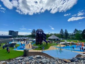
Riverfront Park is an iconic part of Spokane. Since 1974, this has been a gathering place for families, a venue for all kinds of events, and an all-around fun place to be. And as of May 2021, it’s home to a new Ice Age Floods themed playground.
Riverfront Park encompasses 100 acres of land that has quite a history. Native Americans gathered and fished at the nearby falls, and pioneers settled here and started the city of Spokane in the late 1800s. But it was in 1974, when Spokane hosted Exposition '74, "The World's Fair," that this park was really put on the map.
|
|
|
|
|
|
|
There’s A New Ice Age Floods Themed Playground And Splash Pad At Riverfront Park In Spokane.
|
|
|
Construction for the Ice Age Floods playground officially started in August of 2020, although the crew broke ground a year earlier. With the ground made of rubber and artificial turf, this is a safe place for kids to play.
|
|
The playground features basketball courts, a wheels park, a splash pad, and multiple play and climbing areas.
|
|
|
|
|
|
|
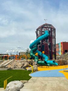
Lat. 46.663661, Long. -118.227088
|
|
This 186-foot waterfall near the southern end of the Cheney-Palouse Scabland Tract is listed as one of the top 20 most beautiful waterfalls in the United States by tripadvisory.com. Located in Palouse Falls State Park, just a few miles off State Highway 261, it is also often listed in the top 10 most breathtaking falls by other publications. It is the official waterfall of the state of Washington. Without the ice age floods roaring over the divide between the Palouse and Snake Rivers, this incredible falls would not have been created as well as the canyon it runs in.
|
|
|
|
If you are passing through Washtucna on the way, be sure to stop at the public restrooms at Snyder Park on Main Street and pick up a free Palouse Falls Chapter brochure for more information about the Falls and canyon and other places to visit in the lower Cheney-Palouse Scabland Tract.
|
|
|
|
|
|
|
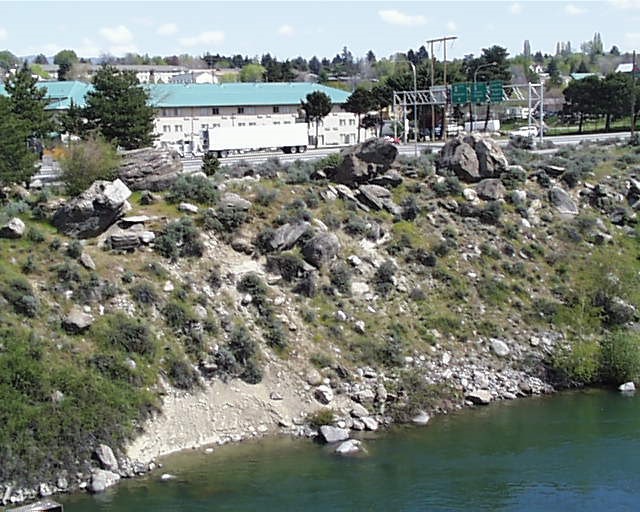
Large Erratic Bedload Boulders - East Wenatchee Apple Capital Loop Trail
|
|
|
|
|
The narrow confines of the Columbia Valley north of Wenatchee allowed the maximum height of the Ice Age Floodwaters to reach about 1,000 feet above the current river level. Soil and rock were stripped from the valley walls.
|
|
|
|
As floodwaters left the restrictive confines of the Columbia Valley and entered the broad Wenatchee area the velocity of the floodwaters slowed and the enormous boulders that had been bouncing along as bedload settled out.
|
|
Subsequent smaller floods removed sand and smaller gravels leaving large “lag boulders” exposed along the existing Columbia River.
|
One of the better locations in the Wenatchee, WA area to view these large boulders (some 40’ in diameter) is along the Apple Capital Recreation Loop Trial in East Wenatchee, Washington.
|
The larger boulders are predominately all gneiss (pronounced “nice”) while the granitic boulders average about three feet in diameter. The granitic boulders were carried by the floodwaters as bedload from the Entiat, WA area, about 15 miles north of Wenatchee.
|
|
Because the granitic boulders were rolled a much longer distance they are all very rounded and smaller compared to the angular gneiss boulders ripped from the cliffs just to the north.
|
|
|
|
|
|
|
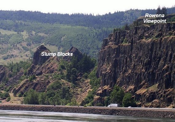
Rowena Gap - A Floods Chokepoint
|
|
Overlooking a major chokepoint (a constriction creating a temporary hydraulic dam) along the Ice Age Floods path, Rowena Crest lies at nearly 700 feet above the Columbia River at the upstream end of Rowena Plateau, a miles-long promontory that protrudes into the path of the river. This promontory forces the river around the plateau through a relatively narrow section of the Columbia River Gorge known as the Rowena Gap.
|
|
The onrushing Ice Age Floods waters easily flowed over the relatively low relief of Dallesport in The Dalles Basin to the east, but as they entered Rowena Gap they were impeded and diverted northward by the Rowena promontory, which created a major chokepoint in the path of the floods as they made their way through the Columbia River Gorge. This chokepoint caused the flood waters at the Rowena promontory to build to nearly 1000 feet deep and flow over the crest, while backing upstream to form temporary Lake Condon in The Dalles basin.
|
|
|
|
The drive to the viewpoint on old Hwy 30 from either east or west is an easy yet spectacular drive through a beautiful section of the Gorge. A roundabout parking area at the viewpoint with a safety wall above a sheer cliff facing eastward toward The Dalles is a great vantage point where visitors can see 1) vertical palisades comprised of stacked layers of Columbia River Basalt, 2) the major Ortley Thrust Fault, 3) a Kolk pond formed by giant whirlpools in the floodwaters, 4) a huge gravel eddy bar underlying the town of Lyle, WA, 5) a number of large rotated fault blocks that slumped off the Rowena promontory, and 6) a field of quixotic low-relief Mima mounds of unknown origins.
|
|
|
|
|
|
|
It is estimated that each of the 40-120 Ice Age Floods may have taken up to a month to completely flush through the system to the Pacific Ocean, but the duration of the flood waters at any point along the path was probably less than a couple of weeks.
|
|
|
|
|
|
|
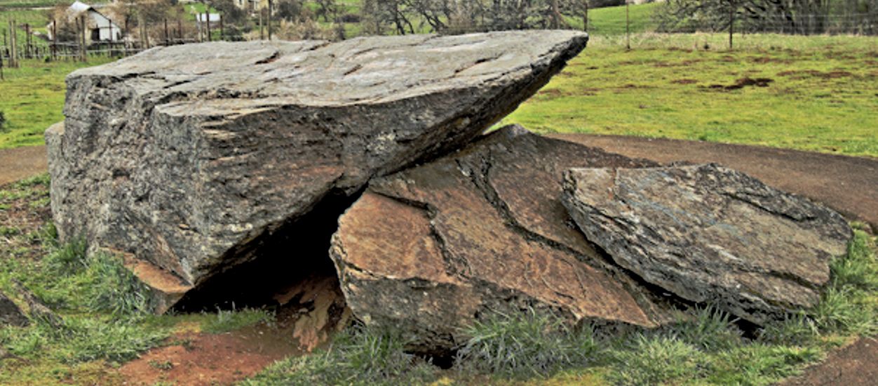
Erratic Rock State Natural Site
|
|
|
|
Six miles west of McMinnville just off Hwy. 18 sits a 90-ton rock that was floated over 500 miles in an iceberg by way of the Columbia River during the Ice Age floods and is said to be the largest piece of argillite (a metamorphic mudstone) originally from the Northern Rocky Mountains outside of Canada and the largest erratic found in the Willamette Valley.
|
|
|
When the iceberg in which it was encased grounded and melted, the rock was left behind at the 306 foot elevation level in the Portland Basin.
|
|
A short uphill hike of two-tenths of a mile leads visitors to the Erratic Rock State Natural Site where they can look out across the vast landscape and imagine the huge amount of water that filled the Willamette Valley during the Ice Age Floods. It would have been about 100 feet over their heads where the rock is now.
|
|
The discovery that erratic rocks in the Willamette Valley were found at the 400 foot or lower elevation was an important piece of the ice age floods story indicating that the water inundated this region from Portland down to Eugene up to 400 feet above present-day sea level.
|
|
|
|
|
|
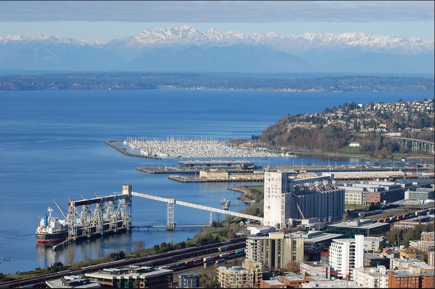
Ice in Puget Lobe Country
|
|
In the waning millennia of the most recent Ice Age, from 18,000 to 15,000 years ago, the Puget Sound area was inundated by thousands of feet of ice which slid south from western British Columbia
|
|
|
|
Visualize ice 5000 feet thick at the Canadian border, 3000 feet thick over Seattle, and 2000 feet thick over Tacoma, with ice extending 150 miles south of the border to Olympia.
|
|
Compare these ice depths with the Space Needle observation deck (elevation 605 feet), and the top of the Tacoma Narrows Bridge towers (elevation 467 feet).
|
Visualize also the depth below sea level of the main Puget Sound basin, which extends 50 miles from Whidbey Island to Tacoma. Its average depth below sea level is 600 feet, but just west of Ballard near the mouth of the Ship Canal it’s almost 900 feet deep. West of Seattle’s Elliott Bay it’s 800 feet deep, and at the Tacoma Narrows it’s 200 feet deep.
|
|
This deep chasm, as well as numerous other channels including Hood Canal and Lake Washington, was carved by ice and meltwater moving under the ice sheet, a testament to the erosive power of water under high pressure. The Puget Sound basin can be seen from many viewpoints, Seattle’s Space Needle being just one of them.
|
|
|
|
|
|
|
|
|
|
|
|
|
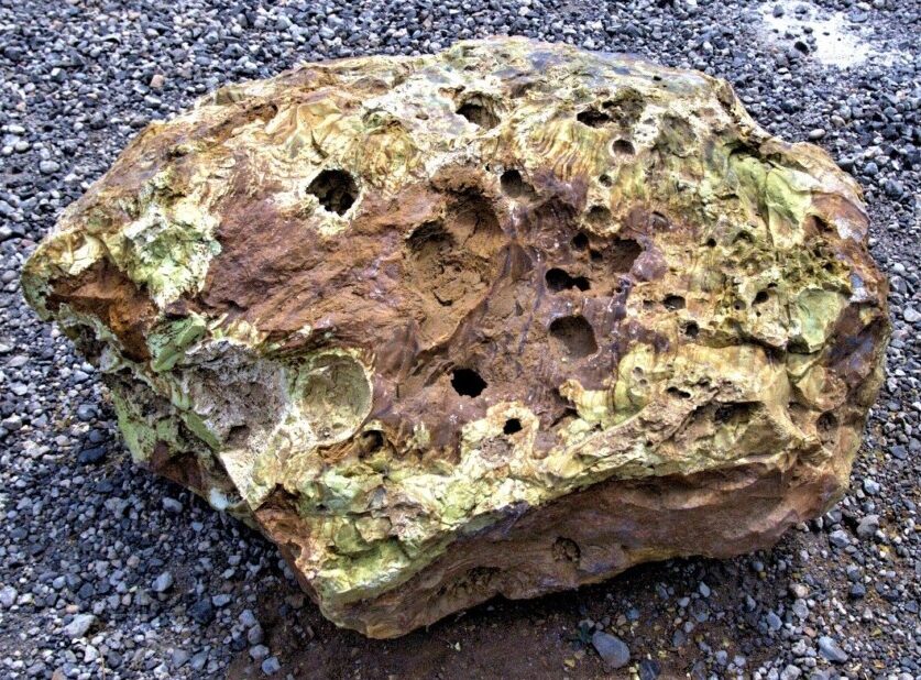
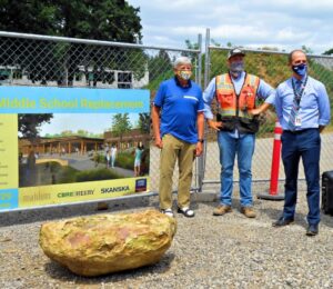
While doing ground preparation for the site of the new Lakeridge Middle School in Lake Oswego, Oregon, it was not unusual for Jacob Parker, Project Superintendent of Construction with Skanska to look at the boulders that had been dug up to see if any would be good for landscaping. What was unusual, this time, was the tan and yellow-greenish boulder that he spotted among the many basalt boulders. Using an app on his cell phone the rock was originally thought to be autunite, which contains uranium. This would not be good news for a school to have a radioactive boulder near students.
|
|
|
|
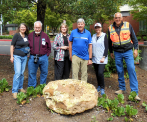
Parker notified Paul Eskeldson, District Project Manager who informed the school district and they wanted it moved off the property. Eskeldson, who had heard a lecture about erratics by Rick Thompson, president of the Lower Columbia chapter of the Ice Age Floods Institute, emailed him a photo asking if the Tualatin Ice Age Foundation might be interested in adding to their collection. Thompson in turn contacted Dr. Scott Burns, Professor of Geology at Portland State University who immediately went out to see the boulder and took Dr. Martin Streck, PSU Professor of Geology specializing in mineralogy who recognized that it was rhyolite.
|
|
Rhyolite, though native to eastern Oregon is not found west of the Cascade Mountains which makes this an extremely rare find. Research could only find one other mention of a rhyolite erratic, in Canby, Oregon, by none other than J Harlen Bretz in his The Late Pleistocene Submergence in the Columbia Valley of Oregon and Washington paper published in the October-November 1919 issue of the Journal of Geology. That erratic has been lost and it is not known if it even still exists.
|
|
|
|
Finding this new boulder where it was, offered a great educational opportunity for the students at the school. On May 17th Dr. Scott Burns, standing next to the boulder, gave a short talk in the morning and again in the afternoon about how the 2,000 pound boulder was likely deposited between 15,000 to 18,000 years ago during the Lake Missoula Floods. Each student who wanted was able to take a small broken piece as a memento.
|
|
|
Skanska issued a press release and invited the media, and several members of the local press came to cover the event. Over the following week the story was picked up by additional media including ABC, UPI and Newsweek giving it national exposure. But the most surprising one was when it appeared in the Borneo Bulletin giving the story international exposure.
The boulder was then carefully hoisted into a truck for transport by Brian Clopton Excavating and taken to the Tualatin Heritage Center where it was installed near several granite and feldspar erratics they had moved in the past.
|
|
|
|
|
|
|
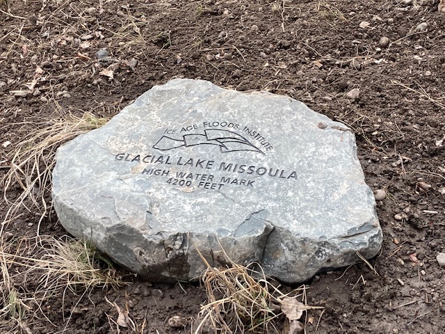
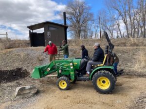
Still another high water marker was placed by the Glacial Lake Missoula chapter in May, and two more were delivered to the Montana Department of Transportation for placement during renovation scheduled for later this summer. These markers all designate the furthest extension of Glacial Lake Missoula in the Clark Fork River valley near Gold Creek – one is located at a popular fishing access site, and the other two will be at pull-offs from I-90 in both directions near Drummond at exit 166.
|
|
|
|
When these placements are completed, the total number of markers will be 10. Five of these are located on popular trails in Missoula – two on Mt Jumbo, two on Mt Sentinel, and one on Mt Dean Stone. These are most easily reached by separate hikes involving a short but relatively steep climb with a panoramic view of Missoula and surrounding mountains. Theoretically they could all be reached in a single day on one long and difficult hike by connecting trails and city streets. We are not aware of anyone who has been able to do that but might want to issue it as a challenge. Creating geo-caches at each marker is also a possibility.
|
|
|
The other markers in addition to the three at Gold Creek locations are all within a short drive from Missoula up the Bitterroot and Blackfoot/Clearwater drainages of the Clark Fork River to Ovando and Lake Como. These are beautiful valleys surrounded by high peaks. Ovando is a popular stop for bicyclists; Lake Como has a swimming beach and a fairly level trail around the lake.
|
|
|
Additional locations are being considered – one possibility is off Miller Creek area trails in Missoula. Locations downstream from Missoula, especially near St Regis or Eddy Narrows would be desirable, but public accessibility to these high mountain areas to place rocks or to reach them on trails is an issue.
The locations and GPS coordinates of these markers are listed on the IAFI interactive map, and they are also individually listed and pictured on the Glacial Lake Missoula chapter website – GlacialLakeMissoula.org - under Local Highlights. The markers are all identified by Glacial Lake Missoula wording with the IAFI logo and the high water elevation, but only those to be placed by the Montana DOT will have explanatory signage.
|
|
|
|
|
|
News from the IAFI Store
|
The IAFI Store is going to be adding another new publication beginning the week of July 18. "Geology Underfoot in Southern Idaho" from Mountain Press Publishers is expected to arrive within a few days and will be added to the store's catalog of items. Also the book "Fires, Faults, and Floods" is no longer being printed and has been deleted from the inventory. Check our our offerings at https://iafi.org/shop/
|
|
|
|
|
|
|
|
|
|
|
In what may be the most dramatic mass extinction in Earth's history, an asteroid impacted our planet 66 million years ago near what is now Chicxulub on the Yucatan Peninsula. The resulting hellscape extinguished 75 percent of then living species - including all non-avian dinosaurs. Over the last few years, scientists have discovered many more traces of this cataclysmic impact, providing us with ever greater details of its extreme aftermath - from world-encircling dust to wildfires up to 1,500 kilometers (930 miles) from the impact site. In 2019, a team found fossil records of the immediate hours after, including evidence of debris swept up by the resulting tsunami.
|
Now, researchers have discovered enormous megaripples engraved by the tsunami in sediments 1,500 meters (5,000 feet) below what is now central Louisiana. By analyzing seismic imaging data for central Louisiana, gained from a fossil fuel company., the team determined the imprinted ripple crests form a straight line right back to the Chicxulub crater and their orientation is consistent with the impact.
|
|

|
|
Modelling of this monstrous tsunami suggests its waves would have reached a staggering 1,500 meters high (nearly 1 mile) after the Richter scale 11 megaearthquake triggered by the collision. The aftereffects would have been particularly devastating in the regions surrounding the impact site, sweeping sea life onto land and land life into the sea. "Tsunami continued for hours to days as they reflected multiple times within the Gulf of Mexico while diminishing in amplitude," the team wrote. What carved out the ripples we can still detect today were the forces from the massive walls of water smashing into the shallow shelf near the shores, and reflecting back towards their source.
|
|
|
|

|
|
These megaripple features have average wavelengths of 600 meters and average wave heights of 16 meters making them the largest ripples documented on Earth. Compare that to the largest Camas Prairie megaripple at 289m x 17m.
|
|
|
|
|
|
|
|
|
|
|
Members who want to do a short article, or describe a field trip location of interest, or describe some geologic problem or site, can use our online form to submit a question or write-up to our technical committee for an answer or review before we post it on our Geology Corner page.
|
|
|
|
|
|
Ice Age Floods National Geologic Trail
|
|
|
|
|
|
|
|
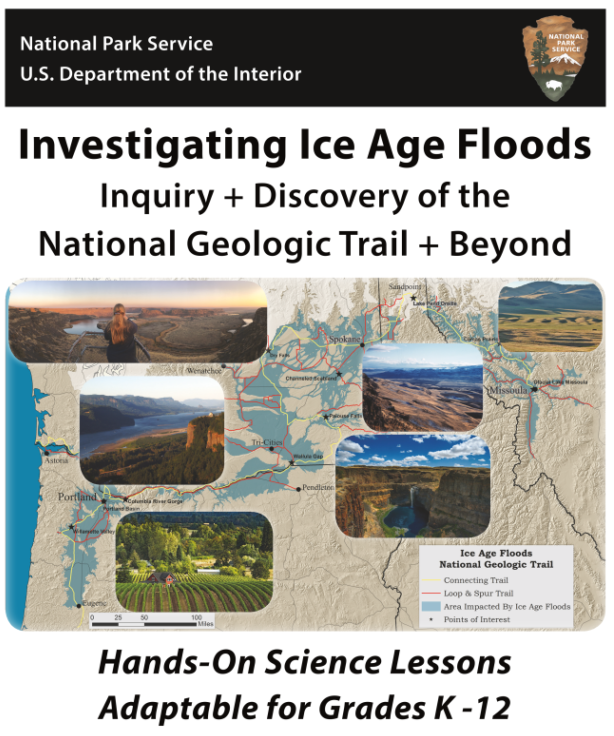
Join educators from around the region as we explore best practices for engaging students in investigations into the phenomena that transformed Northwest landscapes and the practices scientists have used to unlock the mysteries of the Ice Age Floods. This is the unveiling of the recently completed Investigating Ice Age Floods: Inquiry & Discovery of the National Geologic Trail & Beyond curriculum, created by Rick Reynolds, M.S.Ed., Founder of Engaging Every Student, in collaboration with scientists, educators, tribal experts, and other partners. Rick is a passionate veteran educator who will also be presenting the hands-on workshop in collaboration with partners. Lesson plans are targeted to grades 3-8 and adaptable for grades K-12.
|
|
|
|
The workshop and educator’s guide provide adaptable lesson plans and other resources to help you engage students with the forces that created our dramatic landscapes. This includes the most recent Ice Age Floods some 18,000 to 15,000 years ago, which crossed Montana, Idaho, Washington, and Oregon, as well as the forces that created the rocks they eroded and more. Students experiment with scientific phenomena, ask questions, analyze and interpret data, construct explanations, engage in argument from evidence, and obtain, evaluate and communicate information. In short, they get to be scientists as they explore the awe-inspiring phenomena of our Northwest (NW) landscapes and the processes that created them through hands-on investigations, field studies, and other engaging projects.
|
|
|
|
One of our goals is to help students develop an appreciation of our unique NW landscapes and the immense area affected by the Floods. This also provides an ideal, place-based springboard to explore Disciplinary Core Ideas, Crosscutting Concepts, and Science and Engineering Practices. The cross-curricular lesson plans provide an inquiry-driven, experiential program aligned to the Common Core State Standards and environmental literacy, as well, in a way that inspires students and supports quality science education through memorable projects that infuse the arts and other content areas.
|
|
|
When the lesson plans are delivered in sequence, a storyline develops, using the creation of our NW landforms as a compelling framework to help you cover core concepts and improve student skills. The curriculum should not compete with other curricular goals for classroom time.
Presented by: National Park Service, Ice Age Floods National Geological Trail, Lake Roosevelt National Recreation Area, The River Mile Network, Engaging Every Student, and the REACH Museum
|
|
|
|
Investigating the Ice Age Floods - FREE Educators Training
Inquiry & Discovery of the National Geologic Trail & Beyond
August 13, 2021, 9:00 AM to 4:00 PM (PDT) - includes 6.5 STEM Hours
Presented in a hybrid format of virtual and in-person options.
|
|
|
|
|
|
|
|
|
Time in nature promotes overall health and wellness benefits. A visit to a national park can boost physical, mental, social, and psychological health.
|
|
|
|
|
|
Upcoming Calendar Events
|
|
|
|
Jul 15 @ 7:00 pm – 8:00 pm – “Ready or not: Cascadia Preparedness” by Althea Rizzo - Zoom Lecture
|
|
Sep 14 @ 6:45 pm – Sep 21 @ 8:15 pm - Topic TBD by Dr. Stephen Reidel - Zoom Talk
|
|
Sep 16 @ 7:00 pm – 8:00 pm – “Traveling the Ice Age Floods National Geologic Trail” by Rick Thompson - Zoom talk
|
|
|
|
THANK YOU IAFI MEMBER SUPPORTERS
|
Every member at every membership level is vital to IAFI’s continued success. Your support helps us meet our mission of providing the Ice Age Floods story to the public and continuing our work on the Ice Age Floods National Geologic Trail. Every gift counts, no matter the size. Thank you for making the IAFI what it is today and for helping shape it for the future.
|
|
|
|
|
|
Ice Age Floods Institute (IAFI) is a 501(c)(3) tax-exempt, non-profit educational organization (EIN 91-1658221), founded in 1995 and recognized as an official authority on the Ice Age Floods, providing accurate, scientific-based advice to members and the public. We were instrumental in 2009 Federal legislation authorizing National Park Service designation of the
Ice Age Floods National Geologic Trail (IAFNGT).
|
|
|
|
|
|
|