|
|
|
|
|
|
|
|
|
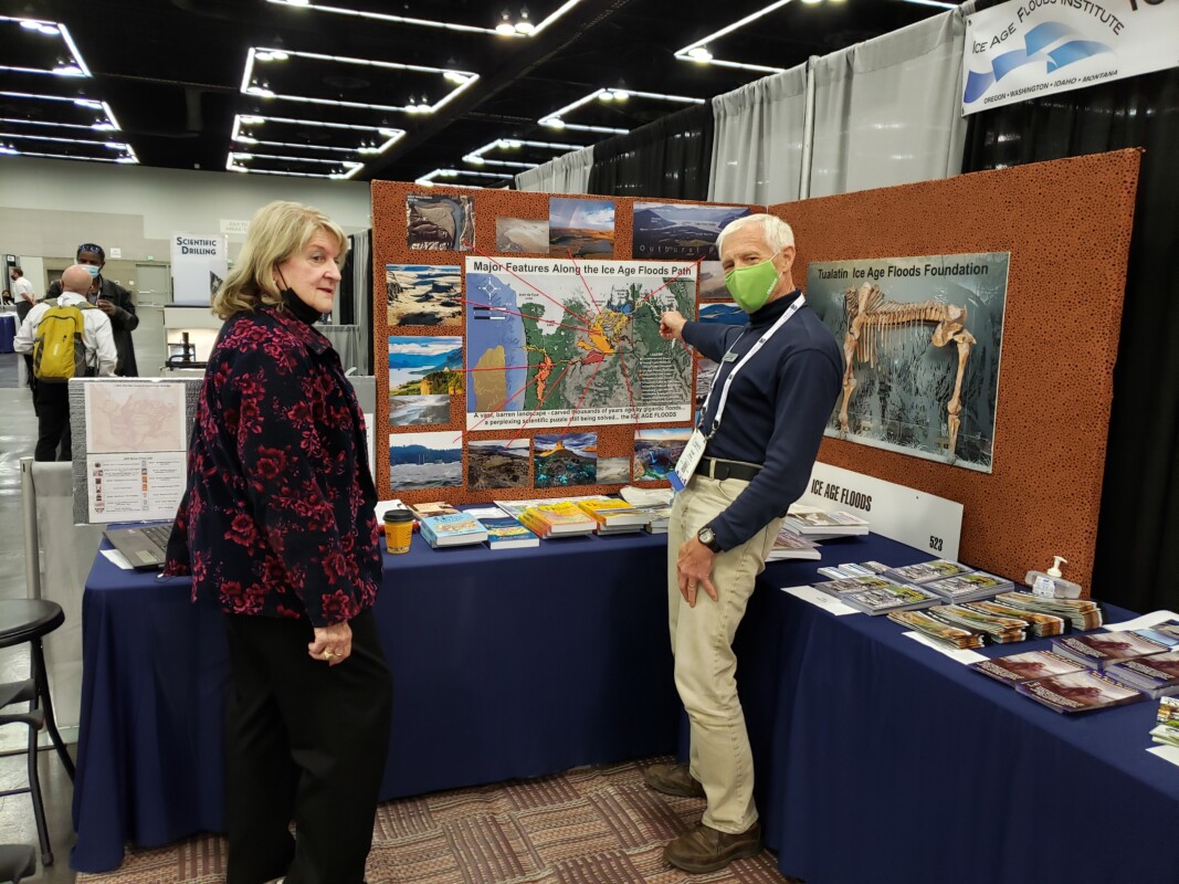
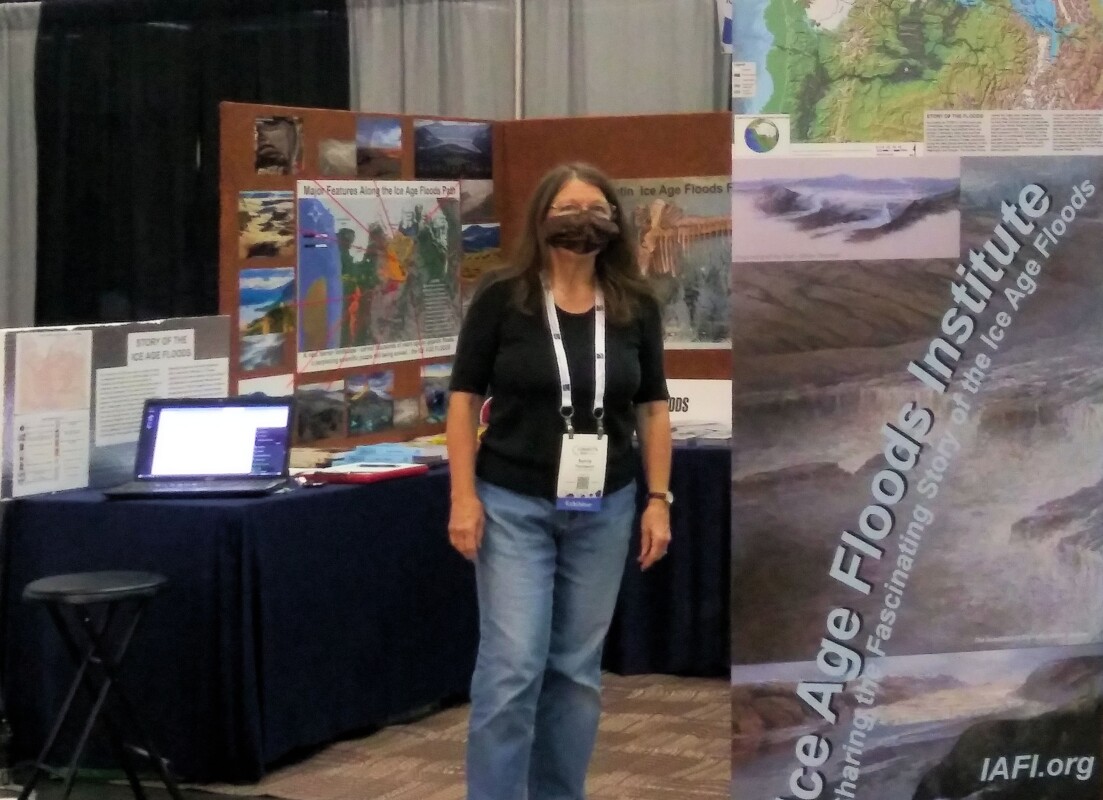
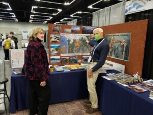
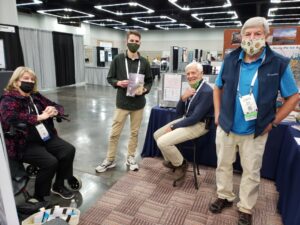
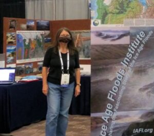
In August the Ice Age Floods Institute was offered an opportunity to share an exhibitor booth with the Tualatin Ice Age Floods Foundation (TIAFF) at a major geological conference, the October 10-13 Geological Society of America (GSA) Convention in Portland, OR. This gave IAFI an opportunity to present the Floods Story and educate a worldwide assemblage of geological professionals, researchers, and students, many of whom were not even aware of the Floods or their immense scope. The IAFI Board jumped at this opportunity, approving the registration cost and putting the booth development in the hands of the Columbia River Gorge Chapter President and IAFI Webmaster, Lloyd DeKay, aided by IAFI Membership Secretary, Sylvia Thompson, who also represented TIAFF along with Dr. Scott Burns of Portland State University.
|
|
|
|
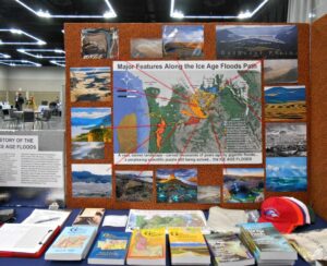
With Dr. Burns influence, we were able to acquire a corner booth space very near the main GSA area that ensured a good parade of participant traffic past our booth. We used 3D modeling software to design the booth to scale, then began assembling the materials for the booth. We used QGIS software, with assistance from Stacy Warren of Eastern Washington University, to develop a new map that highlighted the Floods paths, various glacial and temporary lakes along the floods path, as well as the final resting place of much of the sediment eroded by the Floods on the Astoria Submarine Fan. We then printed the map and other images, purchased, trimmed and covered 2” foam insulation boards for display walls, borrowed tables, made table covers, and gathered IAFI Store materials for sale.
|
|
|
|
|
The day of reckoning came Oct. 8th, when we moved everything to the Oregon Convention Center and set it all up. The Exhibit Hall opened at 5:00pm and we began telling the story that would repeat many times over the next 4 days to people from around the world. We talked with relative locals (WA, OR, ID, MT, NV and CA), people from other parts of the US (at least AK, AZ, UT, CO, TX, AR, IA, KS, KY, IL, MN, WI, LA, GA, NC, SC, AL, FL, NJ, NY, MA, NH, VT, RI, CT), and several countries (including Canada, Finland, Holland, UK, Italy, Morocco, Zimbabwe, India, China, Australia, Columbia, Mexico, and Costa Rica). In all, there were 2,700 in-person participants this year. Our booth was one of the most popular and
usually had 2-5 people at a time looking at the displays.
|
|
|
Geology luminaries such as Vic Baker, Richard Waitt, Scott Burns, Bruce Bjornstad and Nick Zentner also stopped by, attracting even more visitors to the booth. We gave away National Park Service, IAFI and TIAFF brochures and we sold books, maps, hats and t-shirts as well as our packets of chapter brochures.
|
|
|
|
Though it involved a lot of time and work for the members and volunteers who manned the booth, we feel it was well worth the effort to educate and spread the Story of the Ice Age Floods. Many thanks to IAFI members Lloyd DeKay, Sylvia and Rick Thompson, and TIAFF volunteers Jerianne Thompson, Yvonne Addington and Linda Moholt for helping make this effort a stunning success. And we now have materials and experience that will serve well for future professional, educational and general public events like this.
|
|
|
|
|
|
|
Get Out and Explore the Ice Age Floods
|
|
Our website, IAFI.org, includes Interactive Exploration Maps, Floodscapes articles and Field Trip Guides that can be your guides to literally hundreds of Ice Age Floods and geology-related features throughout our Pacific Northwest region. Please do what you can to stay healthy while you GET OUT AND EXPLORE THE ICE AGE FLOODS
|
|
|
|
|
|
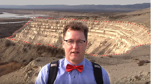
White Bluffs at Hanford Reach (46.642855°, -119.403263°)
|
Instead of the nearly ubiquitous basalt cliffs and boulders of central Washington, the White Bluffs area features a series of 50-170 m tall bluffs and badlands underlain by Columbia River basalts. These are outcropping layers of the Ringold Formation comprising most of a 600-ft high escarpment exposed along the north and east banks of the Columbia River in south-central Washington. These ancient river and lakebed sediments were laid down by the Columbia and Snake River systems 8.5 to 3.4 million years ago.
|
|
|
However, a section of the White Bluffs are a much younger stack of slackwater rhythmite deposits that filled a paleochannel eroded into the Ringold Formation, These late Ice Age rhythmites are only 17,550-12,500 years old. They were laid down as each of the 40 or more Ice Age Floods backed up behind the narrow constriction at Wallula Gap, submerging the entire White Bluffs area under temporary Lake Lewis.
Up to about a dozen rhythmites, composed mostly of sand from as many floods, occur within the channel fill. At the top of most rhythmites is a layer of wind-blown sand suggesting a period of dryness separated each flood. Sediment thicknesses and sedimentary structures in each of the beds give a sense of the tremendous sediment load and the relatively calm conditions of the ponded flood waters.
|
|
The White Bluffs are located along the east side of the Columbia River, across from the former towns of Hanford and Whitebluffs, on the Hanford Reach National Monument where the atomic age was born. The bluffs have been exposed by the Columbia River down cutting and moving laterally against the deep silts and sands and old soil horizons that make up the bluffs. These towering white bluffs, massive sand dunes, and the last free flowing nontidal section of the Columbia River all help make the Hanford Reach one of the most dramatic natural areas in the state.
|
|
|
|
|
|
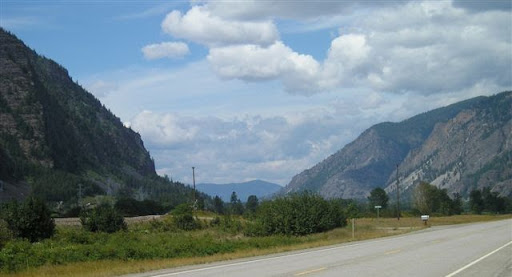
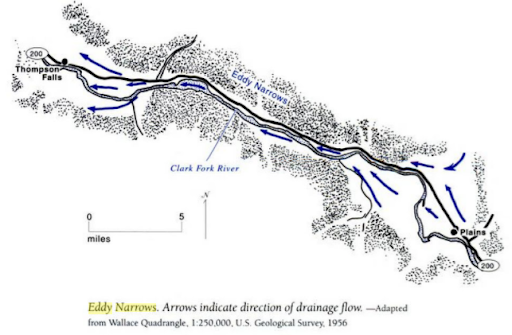
Eddy Narrows (47.5582402°, -115.1331995°)
|
|
The flume shaped section of this canyon is the throttle that controlled the flow rates of the giant Ice Age Floods after the ice dam holding back Glacial Lake Missoula failed catastrophically. Near the end of the last Ice Age a lobe of the continental ice sheet covering western Canada repeatedly formed that ice dam blocking the only river outlet draining most of central Montana. A huge Glacial Lake Missoula slowly backed up behind the dam until it was up to 2000’ deep with up to 550+ mi3 of water (approximately the same volume as Great Lakes Erie and Ontario today), Eventually the volume of lake water overpowered and catastrophically broke up the ice dam, sending all that water rushing out of the basin right through Eddy Narrows. There is evidence that this happened from 40 to over 120 times before the ice sheet finally retreated.
|
|
|
|
|
|
The valley walls in Eddy Narrows were scoured by the Ice Age Floods to nearly bare bedrock up to 1000’ above the valley floor. Depending on depth of the lake, this flume section would have seen flow rates ranging from 17 km3/hr up to 60 km3/hour, with maximum flow speeds approaching 130 km/h (80 mph). These flow rates would allow the giant Glacial Lake Missoula to empty in as little as 3 days, sending all 550+ cubic miles of water rushing across central Washington and through the Columbia River Gorge to the Pacific Ocean.
|
|
|
|
|
|
|
|
|
|
|
|
|
|
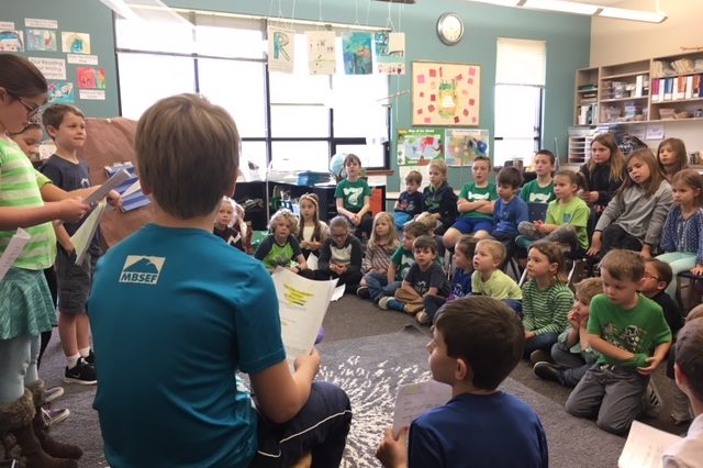
For Coeur du Deluge Chapter President Tony Lewis, an opportunity to lead a Sandpoint 4th grade class in a learning unit on “how Idaho landforms were created” came up suddenly on Oct. 8th. Terese Luikens, the 4th Grade Teacher at Southside Elementary School had 19 students wanting “an actual field trip where you can show and tell us about how glaciers formed some of our lakes.” 3 days later Tony was in front of Mrs. Luikens’ 19 excited and exuberant students, struck by how 4th graders react to rocks and a guest presenter. Hands were up, even before his “Landforms of North Idaho: How They Were Formed and What Caused Them” presentation started. How can you NOT be swept up in their enthusiasm and amazed by their unending questions, some of which are actually related to the topic? They were more excited when he left their school than when he had arrived, and the field trip was happening two days later!
|
|
|
|
Unfortunately, the weather didn't cooperate. It was cold and windy with a chance of rain when they met at the Pavilion at City Beach in Sandpoint, ID at 10 AM. Were these 4th graders put-off by a “little” inclement weather?
|
|
Of course not, but they did seem disappointed when told that they were not allowed to go swimming.
|
|
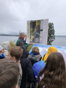
Hands up again, asking questions, wanting to show where they lived, where we were and where we were going on the maps and images Tony had. After an hour reviewing what was talked about on Monday, with more information about David Thompson, the Ice Age Floods, glaciation and the Purcell Trench and how different lakes (Round, Cocolalla, Mirror and Pend Oreille) were formed, we all loaded up for a drive through the bottom of the Purcell Trench, the Pack River Delta and finally to the Geologic Overlook just one mile east of Hope, ID.
|
|

|
Before leaving the bus, the students were given their boundaries and they abided. Although the clouds covered some of the scenes, we could see the steep-faced Green Monarch Mts. where the Purcell Trench Lobe glacier divided into four sub-lobes. One of the sub-lobes went up the Clark Fork River, plugging up the drainage basin and causing Glacial Lake Missoula. Another lobe moved southward, deepening the basin now occupied by Lake Pend Oreille. The students seemed to enjoy viewing the wide-expansive scene of ‘the place where the Ice Age Floods started’. The field trip ended when it started to rain, and the drive back to Sandpoint was uneventful, although I was admonished, in a nice but serious way, for walking up and down the aisle because it was dangerous and “I might break my back!” I agreed and took my seat. It was a fun learning experience for me, and I hope it was for them also.
|
|
|
|
|
|
News from the IAFI Store
|
The IAFI Store has added another new publication. "Roadside Geology of Idaho" from Mountain Press Publishers is now available in the IAFI Store's catalog of items. Check all our offerings at https://iafi.org/shop/
|
|
|
|
|
|
|
|
|
|
|
|
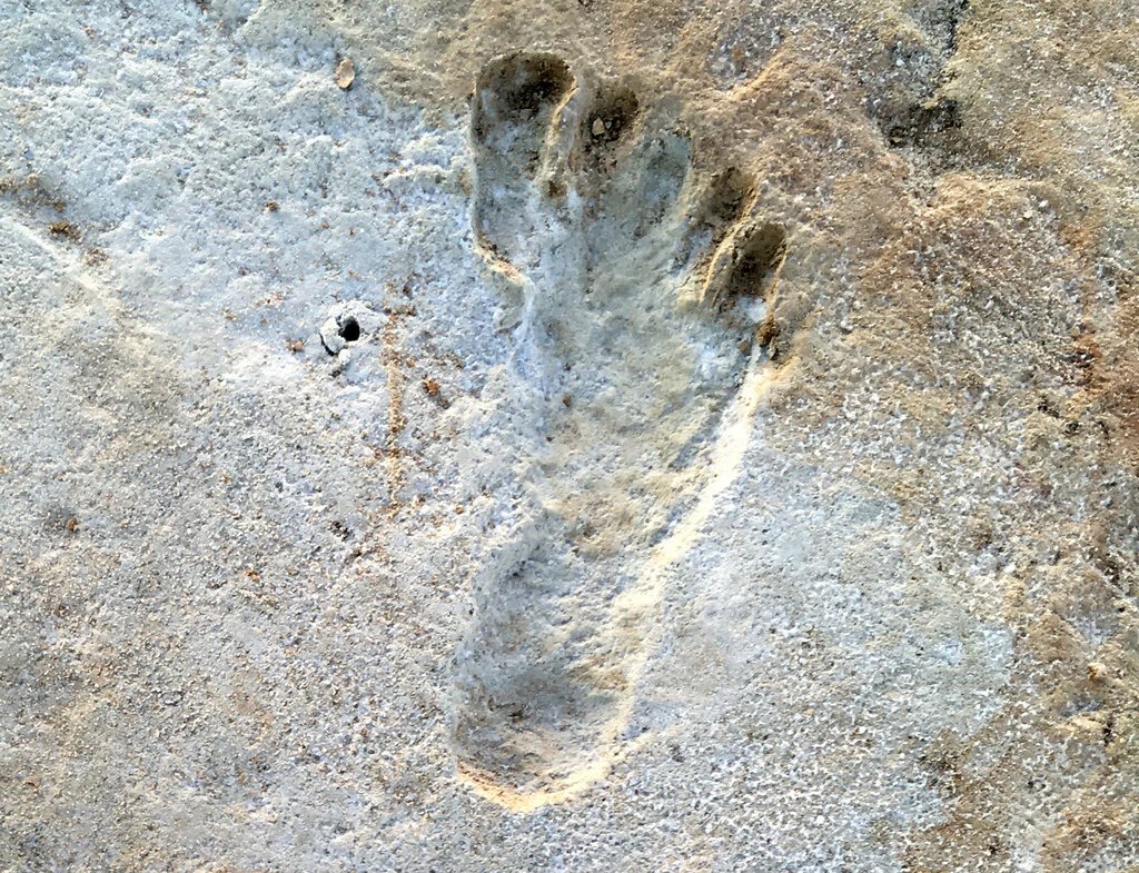
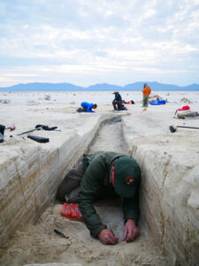
Articles in Science Alert and the New York Times report on a well documented age for many sets of human footprints as old as 23,000 years in the ancient lake shore sands of White Sands, New Mexico. "The footprints were first discovered in 2009 by David Bustos, the park’s resource program manager. Over the years, he has brought in an international team of scientists to help make sense of the finds. Together, they have found thousands of human footprints across 80,000 acres of the park. One path was made by someone walking in a straight line for a mile and a half. Another shows a mother setting her baby down on the ground. Other tracks were made by children."
|
|
|
Beginning in 2019, two United States Geological Survey (USGS) research scientists, Dr. Jeffrey Pigati and Kathleen Springer, began working on the site and found ancient seeds of ditch grass associated with various sets of footprints. The oldest footprints so far have been found in seed beds radiocarbon age-dated as old as 22,800 years, and the youngest footprints dated to about 21,130 years ago. Some scientists still have concerns the seeds might have absorbed older carbon from the lake waters. But in general this research is strongly indicative that humans were present in the Americas long before the generally accepted 15,600-year-old footprint found in Chile or the 13,000 year age of human tools found near Clovis, NM.
|
If humans were well established in New Mexico 23,000 years ago, they must have started spreading down from Alaska long before that. “That starts to wind back the clock,” said Dr. Reynolds of Bournemouth University. Some researchers feel the migration might have been along the coast during the last major ice advance of the Pleistocene, while others argue people could have traveled inland more than 32,000 years ago, before Ice Age glaciers reached their maximum extent and blocked off that route.
|
Regardless of the possible migration route, this new evidence opens up new possibilities that humans may have been present in our local area even before the earliest of the Ice Age Floods, about 18,000 years ago. While the floods could have wiped away most traces of early people in the area, the window of human habitation may be much greater than scientifically documented to date.
|
|
|
|
|
|
|
Members who want to do a short article, or describe a field trip location of interest, or describe some geologic problem or site, can use our online form to submit a question or write-up to our technical committee for an answer or review before we post it on our Geology Corner page.
|
|
|
|
|
|
Ice Age Floods National Geologic Trail
|
|
|
|
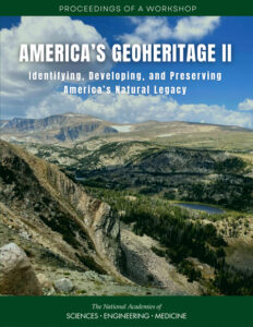
Tim Conners, NPS Geologist, is asking us to share a new paper from The National Academies Press: “America’s Geoheritage II”. It is a wonderful collection of current thinking on Geoheritage, geotourism, and what they mean.
|
|
|
|
|
|
Identifying, Developing, and Preserving America's Natural Legacy - America is endowed with places that embody a rich geoheritage, from sites where indigenous people subsisted for millennia, to mines that furnished the raw materials that built U.S. industry, to mountain ranges and river gorges with unparalleled recreational opportunities, to field sites where students can truly understand a geological process, to places of aesthetic or spiritual value, and many more across all states and territories.
|
In order to assess the status of geoheritage and the activities of its practitioners in the United States in light of social, political, and environmental changes over the past ten years, the National Academies of Sciences Engineering and Medicine convened a series of virtual webinars and a workshop. From September to December 2020, a Distinguished Speakers Webinar Program composed of eight webinars provided an overview of geoheritage initiatives, as well as focused presentations on geoheritage related to federal and state lands, cultural heritage, education, research, and economic development and geotourism.
|
|
|
|
In January 2021, 101 land managers, state geologists, educators, researchers, and members and staff of professional societies and nongovernmental organizations participated in a virtual writing workshop to aggregate and organize community input on strategies and best practices in developing geoheritage sites across the United States. The participants were divided into focus groups that roughly aligned with the topics explored in the fall 2020 workshops. The groups worked synchronously and asynchronously over the course of a week, then presented their ideas in a plenary session. This free publication summarizes the presentations and discussion of the webinars and workshop.
|
|
|
|
|
|
|
Time in nature promotes overall health and wellness benefits. A visit to a national park can boost physical, mental, social, and psychological health.
|
|
|
|
|
|
Upcoming Calendar Events
|
|
|
Thu, Oct 21 @ 7:00 pm – 8:00 pm - “More Valuable than Gold? Sea Otters of the Oregon Coast” - Zoom lecture by Cameron LaFollette for IAFI-Lower Columbia Chapter & Tualatin Historical Society
|
Mon, Nov 1 @ 6:45 pm – 8:30 pm - “Remarkable Megaflood in SW British Columbia” - Zoom Meeting
|
Tue, Nov 9 @ 6:45 pm – 8:15 pm - Zoom Lecture by Dr. Marli Miller - Zoom Meeting
|
Thu, Nov 18 @ 7:00 pm – 8:00 pm - “Glaciers – Sculptors of the Swiss Alps” Zoom Lecture by Scott Burns for IAFI-Lower Columbia Chapter
|
|
|
|
THANK YOU IAFI MEMBER SUPPORTERS
|
Every member at every membership level is vital to IAFI’s continued success. Your support helps us meet our mission of providing the Ice Age Floods story to the public and continuing our work on the Ice Age Floods National Geologic Trail. Every gift counts, no matter the size. Thank you for making the IAFI what it is today and for helping shape it for the future.
|
|
|
|
|
|
Ice Age Floods Institute (IAFI) is a 501(c)(3) tax-exempt, non-profit educational organization (EIN 91-1658221), founded in 1995 and recognized as an official authority on the Ice Age Floods, providing accurate, scientific-based advice to members and the public. We were instrumental in 2009 Federal legislation authorizing National Park Service designation of the
Ice Age Floods National Geologic Trail (IAFNGT).
|
|
|
|
|
|
|