|
|
|
|
|
We hope you enjoy our newsletter and we appreciate any questions, comments or corrections by email to our Webmaster/Newsletter Editor: Lloyd DeKay
|
|
|
|
|
|
|
Ice Age Floods Institute members and guests will come together at Dry Falls, Camp Delany in Sun Lakes State Park, June 2-3, 2023, as we Rock-Out with 2 days of fascinating presentations, hikes, a field trip, meals, and importantly, getting to know our organization and each other better.
|
This rethink of our Annual Membership Meeting includes a camping option in an important and spectacular Ice Age Floods setting. The Rock-Out Jubilee will take place at multiple locations in and around Sun Lakes State Park. Camp Delaney, the environmental education and conference center located within Sun Lakes State Park, will be the festival hub.
|
Registrations had to be closed early due to the overwhelming response, but the festivities will include several "Open to the Public" events beginning the evening of June 1, as well as the "Registered Members Only" events.
|
|
|
|
Explore the Ice Age Floods ... and More
|
|
|
|
|
|
|

|
|
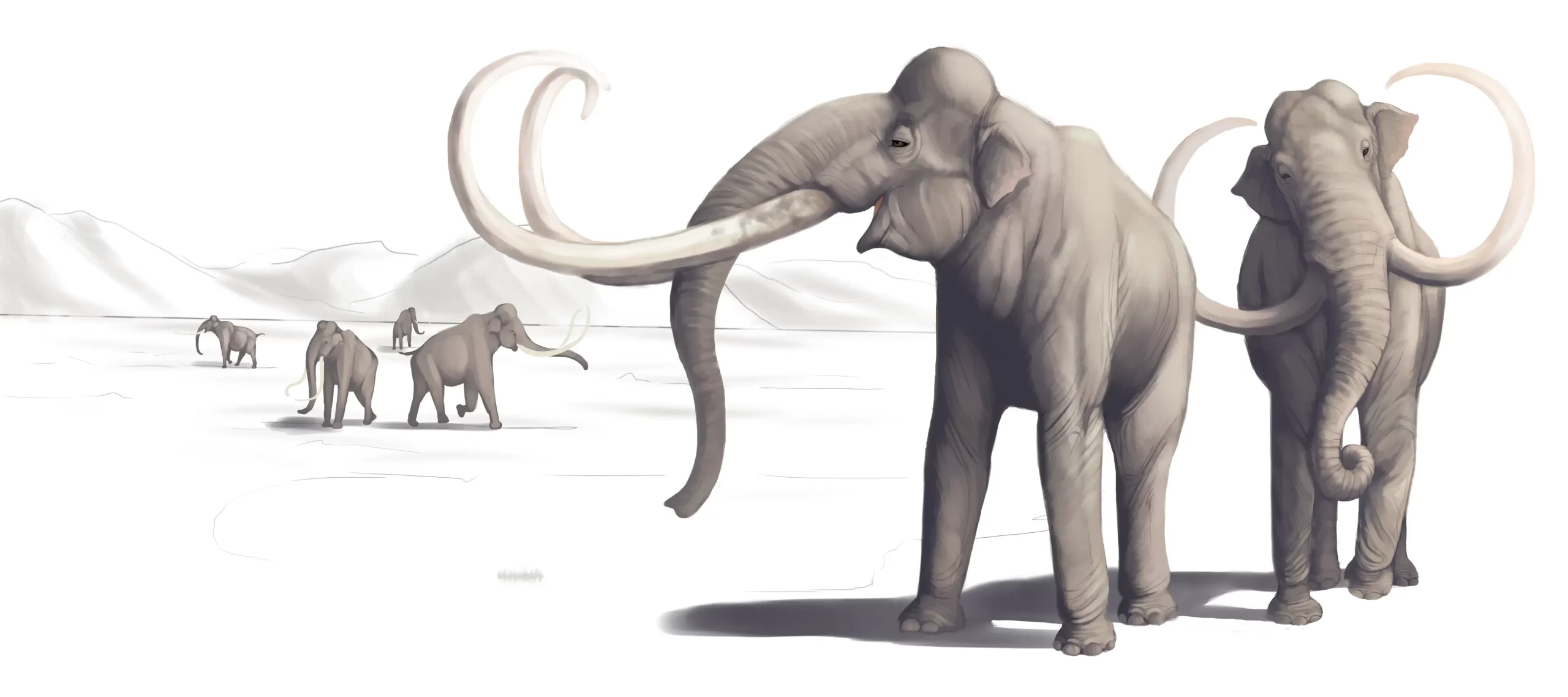
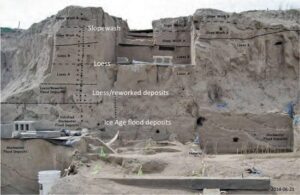
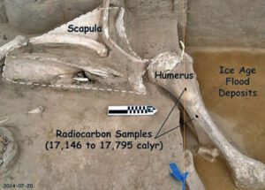
The Tri-Cities area, home to the Lake Lewis Chapter of IAFI, is inching its way into spring and it’s time to say goodbye to winter. And for some of us, it’s time to begin the 2023 dig season at Coyote Canyon, the resting place of a 17,500-year-old Columbian mammoth.
|
|
Coyote Canyon is just a few miles southwest of Kennewick in the Horse Heaven Hills. Last month we cleaned up the winter erosion and set up the field equipment so work can begin in earnest in April. Several bones, yet to be identified, were partially exposed last fall and hopes are high for exposing and removing them this summer.
|
|
|
|
This elephant relative was deposited on the west side of Coyote Canyon during one of the earlier Ice Age floods and is buried by possibly six layers of floods sediment. Numerous erratic rocks have been found among the bones.
|
|
|
Article by Gary Kleinknecht
|
|
|
Just before the pandemic temporarily paused work at the site, a local high school girl was assigned the task of identifying rock types of a cluster of small erratics buried near the animal’s left shoulder blade. She then identified outcrops of the same types of rocks in northern Idaho, at or near the ice dam. Finally, she documented her work with a poster and presented it at the 2019 GSA conference in Portland, Oregon.
|
|
|
|
With digging comes tourism. As usual, public tour lists have filled for spring and summer-fall tour reservations will open on June first. To sign up for a tour the public can visit our new website, www.mcbones.weebly.com. School and private group tours are also available. At the time of this writing, we have scheduled six public tours, 30 elementary class tours and 13 group tours, including one for vision impaired and one for non-English speakers. All of our presentations emphasize the importance of the Ice Age floods to the mammoth story at Coyote Canyon.
|
|

|
|
|
|
|
|
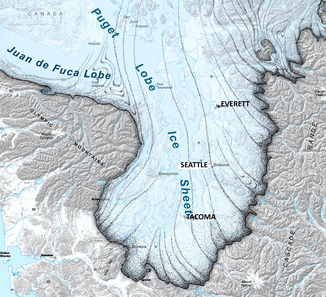
Although the Seattle region was not impacted by the large floods from Glacial Lake Missoula, Glacial Lake Columbia, or other glacial lakes east of the Cascades, the Puget Sound region has its own glacial story to tell. It's interesting that J Harlan Bretz, who first imagined that a massive flood produced the Floods features in the Columbia Plateau, also did his PhD on "Glaciation of the Puget Sound Region".
|
|
|
|
The Puget Lobe of the Cordilleran Ice Sheet advanced and retreated over the Puget Lowland at least seven times during the Quaternary Ice Age. In the process, it left behind rocks, sediments, and other geologic clues that tell the intriguing story of ice, proglacial lakes, and flooding across the landscape near Seattle.
|
|
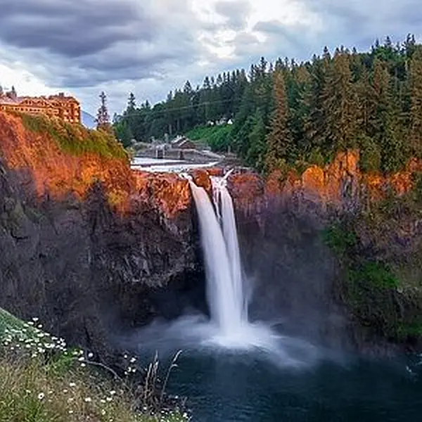
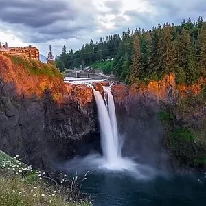
Snoqualmie Falls, near North Bend, WA east of Seattle is a popular tourist destination. At the falls, the Snoqualmie River plunges 82m over a wall of volcanic rock. Few tourists, however, understand the role that the Puget Lobe of the Cordilleran Ice Sheet played in the formation of the falls.
|
|
|
Prior to glaciation, Snoqualmie Falls did not exist, instead, the river flowed in an incised channel east of the current falls. As the Puget lobe advanced into the Puget Lowland about 18,700 years ago, the glacier’s eastern margin blocked drainage from rivers flowing out of the Cascades, including the Snoqualmie River. A large glacial lake known as Glacial Lake Snoqualmie formed over North Bend and over the Snoqualmie Valley. Tokul Creek, one of the tributaries, formed a thick underwater delta in the lake as its sediments poured into Glacial Lake Snoqualmie.
|
|
|
When the Puget Lobe retreated, Glacial Lake Snoqualmie drained to the west and the Snoqualmie river attempted to follow its original channel. However, the original course of the river was blocked by the delta deposits from Tokul Creek and the river was forced to flow over a narrow band of rocks from an eroded volcano further to the south. Snoqualmie Falls flows over this volcanic rock today, but since the last glacial maximum, cataract recession has rapidly eroded the rocks back to a 200m wide band of andesite and volcanic breccia. Behind the thin volcanics is a thick layer of soft alluvium. At the current rate of recession, the Snoqualmie River will erode through the volcanic rock in about 7,200 years. When that happens, the river will hit the alluvium and the falls will quickly devolve into a series of rapids. You might want to hurry to see the falls before they disappear!
|
|

|
|
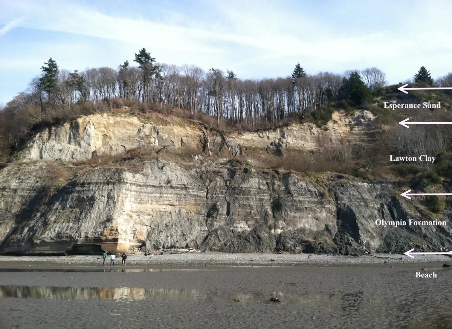
Other glacial lakes were formed at the southern margin of the Puget Lobe near modern day Seattle. As the Puget Lobe advanced south, it dammed rivers and streams that were flowing north. In places, the bluffs surrounding modern Puget Sound hold a record of the advancing glacier and the pro-glacial lakes backed up by the ice front. One good place to view these sediments is from the beach at Discovery Park in Seattle.
|
A layer cake of sedimentary units records the pre-glacial river system, the advance of the ice, the damming of the proglacial lakes, and the retreat of the ice sheet to the north.
|
At the base of the cliffs the Olympia Formation records the pre-glacial environment of north-flowing rivers and streams. The Lawton Clay layer indicates the formation of proglacial lakes. The Esperance sand represents a period of glacial retreat.
|
|
The glacier that repeatedly covered the Puget Lowland left behind multiple geologic clues for us to interpret. The Puget Lobe of IAFI welcomes members from other chapters to join us as we explore the glacial history of the Puget Lowland.
|
|

|
|
|
|
Article by Dale Lehman, Puget Lobe Chapter President
|
|
|
|
|
|
|
|
|
|
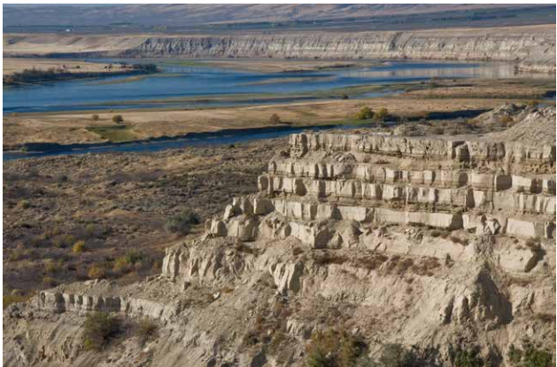
The White Bluffs are located along the east side of the Columbia River, across from the former towns of Hanford and Whitebluffs, on the Hanford Reach National Monument where the atomic age was born. The bluffs have been exposed by the Columbia River down cutting and moving laterally against the deep silts and sands and old soil horizons that make up the bluffs. These towering white bluffs, massive sand dunes, and the last free flowing nontidal section of the Columbia River all help make the Hanford Reach one of the most dramatic natural areas in the state.
|
|
|
Appearing much different than the nearly ubiquitous Columbia River basalt cliffs and boulders of central Washington, the White Bluffs area features a series of 50-170 m tall buff-colored bluffs and badlands underlain by those basalts. These are outcropping layers of the Ringold Formation comprising most of a 600-ft high escarpment exposed along the north and east banks of the Columbia River in south-central Washington. These ancient river and lakebed sediments were laid down by the Columbia and Snake River systems 8.5 to 3.4 million years ago.
|
|
However, a section of the White Bluffs are a much younger stack of slackwater rhythmite deposits that filled a paleochannel eroded into the Ringold Formation, These late Ice Age rhythmites are only 17,550-12,500 years old. Sediment thicknesses and sedimentary structures in each of the beds give a sense of the tremendous sediment load and the relatively calm conditions of the ponded flood waters.
|
|
They were laid down as each of the 40 or more Ice Age Floods backed up behind the narrow constriction at Wallula Gap, submerging the entire White Bluffs area under temporary Lake Lewis. Up to about a dozen rhythmites, composed mostly of sand from as many floods, occur within the channel fill. At the top of most rhythmites is a layer of wind-blown sand suggesting a period of dryness separated each flood.
|
|
|
|
|
|
|
|
|
|
|
|
|
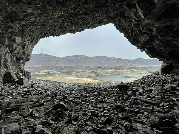
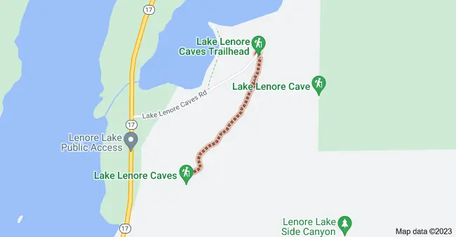
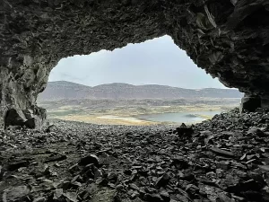
Tucked into the Lenore Canyon are the Lake Lenore Caves. Along with much of the eastern half of the state, Lenore Canyon was formed during the Missoula floods at the end of the last Ice Age, over 13,000 years ago. The glacial flood waters crashed down the canyon, carving through the basalt that makes up the sheer rock walls, creating coulees, ridges, cliffs, plateaus, rock slides, caves and a series of lakes.
|
|
The caves themselves are shallow,. They were created during the Missoula Floods as flood waters ripped chunks of basalt from the walls of the coulee. Post-flood weathering created talus slopes that furnished easy access and temporary overnight camps and storage for at least 5,000 years for hunters and gatherers from villages located elsewhere in the Grand Coulee and along the Columbia River and its tributaries. It is still used today for certain Native American religious ceremonies. It is easy to see why the caves were chosen as a cozy place to stay, as the depth provided plenty of shelter from the elements, while not going so deep that light couldn’t reach the back corners. It is often quite warm and breezy outside, but in the caves it is cool and calm.
|
|
|
A well-marked 1.2-mile out-and-back trail leads from the parking area to some of the caves. It is generally considered an easy route that takes an average of 31 min to complete. This is a popular trail for hiking and walking, but you can still enjoy some solitude during quieter times of day. The best times to visit this trail are March through November. Dogs are welcome, but must be on a leash.
|
|

|
|
The coulee walls in this area are made up of Grande Ronde Basalt flows overlain by the Frenchman Springs and Roza members of the Wanapum Basalt. The lower (colonnade) and upper (entablature) cooling units of individual flows are visible in the coulee walls. Flow unit contacts are sometimes complex to interpret. Some flows pinch out against older flows, some are perhaps due to flows covering an irregular topographic surface on the underlying flow, some may be filling of shallow valleys, and some multiple layers may be pulses of lava from the fluid interior pushing out over the partially formed entablature of a previous lava pulse.
|
|
|
|
|
|
|
|
|
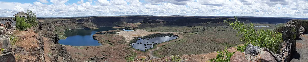
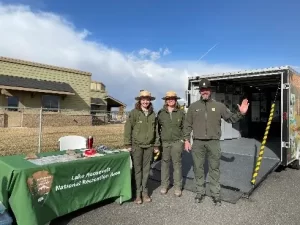
Spring is coming and the trail is starting to wake from its long winter break. Our National Park Service Interpretive Rangers are already out and about with our Mobile Visitor Center. Our team has made lots of contacts at various trade show events around Spokane, WA, and Washington State Parks joined NPS at the Othello Sandhill Crane Festival. Our thanks to Ranger’s Abby, Emilee and David for sharing the Missoula Floods story with over 500 visitors to the Scablands. From April 27th through May 25th the Mobile VC will be traveling to sites around Lake Roosevelt NRA on Thursdays. You can find the Ice Age Floods NGT and Lake Roosevelt NRA Mobile Visitor Center’s schedule and locations on our Ice Age Floods NGT calendar.
|
|
|
You can use the Trail’s NPS App to find out how and to explore more amazing landscapes changed by the Missoula Floods. Some of them are perhaps in your part of the world! I am looking forward to joining Institute members at the IAFI Rock-Out Jubilee in just a couple of months. I’ll see you there or out on Ice Age Floods National Geologic Trail this summer. Have fun and safe travels.
|
|
|
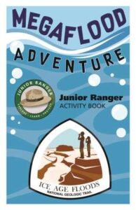
Our Junior Ranger Program test is showing success and has already run out of booklets! Tualatin Library, one of the National Trail’s official partners, has been promoting and sharing our Junior Ranger activity booklet “Megaflood Adventure”. Young explorers can turn in completed booklets for Ice Age Floods NGT Junior Park Ranger badges. National Pak Service is exploring this program and hopes to bring more Junior Rangers into the Missoula Floods community.
|
|
|
|
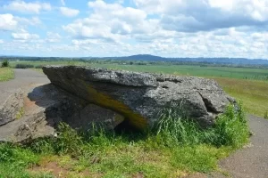
Out on the Trail: Now is a great time to explore the Willamette Valley searching for signs of great Missoula Floods and watching the valley spring to life. You might explore Erratic Rock State Natural Site near McMinnville, Oregon. There you will find a ~90-ton chunk of Precambrian argillite sitting ~150 feet off the valley floor and some 500 miles from where this sort of rock originates. How did that happen?
|
|

|
|
Justin Radford, NPS Ice Age Floods National Geologic Trail Coordinator
|
|
|
|
|
|
|
|
|
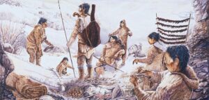
There is a recurring and much debated question: Could there have been indigenous people in the Americas to witness the Ice Age Floods? Evidence is building that they could have been here. Let's explore more!
|
|
|
|
|
|
|
|
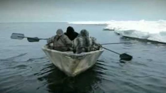
During the last ice age, which route was taken by the first humans to reach the Americas, and did they travel by foot, boat or both?
|
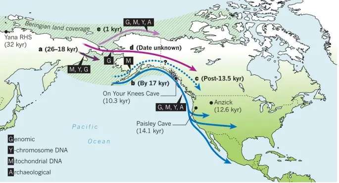
Humans first arrived in North America at least 15,500 years ago. Exactly how they got there, however, constitutes one of the longest-standing debates in archaeology.
|
For decades, scientists assumed that people first arrived in the Americas by walking south from the now-flooded land bridge in the Bering Strait that once connected Russia to Alaska when sea levels were lower during the last ice age. But recent evidence suggests that these people were not the first to set foot on the continent.
|
According to the now-dominant "coastal route theory," that distinction belongs to humans who boated down the Pacific coast several millennia earlier. A 2023 study(opens in new tab), for instance, found that coastal conditions were favorable during two time windows: from 24,500 to 22,000 years ago, and from 16,400 to 14,800 years ago. And while the science is far from settled, the evidence increasingly points to the first Americans arriving by sea or land along the coast.
|
|
"The pendulum is swinging in support of the coastal corridor being the route taken by the first Americans," Michael Waters(opens in new tab), director of the Center for the Study of the First Americans at Texas A&M University, told Live Science in an email. "But we still need the smoking gun: an early site along the coast."
|
|
|
|
Until 20 years ago, the best available archaeological evidence(opens in new tab) suggested that humans first arrived in North America about 13,000 years ago. The rise of the Clovis people — whose 13,400-year-old remains were discovered in Clovis, New Mexico, in the early 1900s — coincided perfectly with the formation of an ice-free corridor along the Rocky Mountains.
|
Scientists assumed that these humans crossed the Bering Land Bridge into what is now Alaska, and then turned south to march onward to New Mexico through that convenient corridor. This remains the prevailing theory as to how the Clovis people made it to the Americas. "It seems very likely that people did arrive from northeast Asia via the ice free corridor once this route was open and viable," Todd Braje(opens in new tab), chair of anthropology at San Diego State University, told Live Science in an email.
|
But recent excavations suggest that the Clovis were not the first Americans. A 2011 paper in the journal Science(opens in new tab) presented evidence of tools crafted by humans in Texas from up to 15,500 years ago, and a 2021 paper in Science(opens in new tab) described 23,000-year-old footprints in New Mexico. (However, the footprint date is disputed by a 2022 study in the journal Quaternary Research(opens in new tab), which posits that the plant seeds the original team used to radiocarbon-date the footprint layer are problematic.
|
|
|
These "pre-Clovis people" would have had to migrate to America long before the ice-free corridor opened up. "The earliest the inland corridor was open is 14,300 years ago," Waters said. "It is impossible to have people in Texas and Idaho at 16,000 years ago, and Florida at 14,600 years ago, come through the corridor. They must have come a different way."
|
How the pre-Clovis people got to America without an inland corridor to take them south from the Bering Strait remains an open question. "With the breaking of the Clovis barrier in the 1990s, we know people were in the Americas prior to at least 14,000 years ago, but when people first arrived and by what route or routes remains unknown," Braje said. "There are now lively debates on the topic but the bottom line is that no one knows definitely."
|
|
The prevailing theory is that the pre-Clovis people arrived by watercraft. "The route taken by the initial migrants was almost certainly along the coast," said Matthew Des Lauriers(opens in new tab), director of the Applied Archaeology Program at California State University, San Bernardino.
|
|
|
|
Des Lauriers described the pre-Clovis as sophisticated maritime hunter-gatherers, who would have cast off south from the Bering Land Bridge and subsisted on fish and game as they voyaged down the Pacific coast. Ultimately, Des Lauriers said, these intrepid seafarers parted ways. Some pre-Clovis people followed rivers inland, while others continued south as far as Chile.
|
"The ocean would always have provided resources for skilled fishermen and hunters," Des Lauriers told Live Science in an email. "The most likely scenario is one of coastal fisher-hunter-gatherers moving along the North Pacific Coast."
|
Recent work from geologists has lent support to the theory that the Clovis people arrived via an inland corridor, while the pre-Clovis people took a coastal route. Beryllium-10 dating of glacial boulders(opens in new tab) along the ice-free corridor suggests that the corridor opened about 13,800 years ago. And studies(opens in new tab) suggest that a strip of unglaciated land should have existed along the Pacific coast of Alaska and British Columbia 16,000 years ago — prime real estate for a coastal corridor.
|
As the field of ancient genetics has blossomed, multiple studies(opens in new tab) have provided additional evidence that the first Americans arrived between 15,000 and 17,000 years ago.
|
"It is gratifying to see the archaeological and genetic evidence converging to tell the same story," Waters said. "Finally, we have a much better understanding of the chronology of the opening of the two corridors, and the evidence now supports a coastal migration route."
|
Nonetheless, physical evidence for both corridors is still lacking. Significant archaeological, genetic and geologic legwork will be necessary before we can firmly point to the lives and times of the first Americans and begin to describe, with confidence, how they arrived in America.
|
|
"There are very few sites along the Pacific Coast that are pre-Clovis in age, and much work needs to be accomplished to find potential early coastal sites," Braje said. "We have no definitive answers about when and how people first arrived in the Americas."
|
|
|
|
|
|
Related Articles On Our Website
|
|
|
|
|
Do you have a question? We might have an answer!
Do you have a fact to share? We have a way to do that!
|
Members who want to do a short article, or describe a field trip location of interest, or describe a problem or some geologic site, can use our online form to submit a question or write-up to our technical committee for an answer or review before we post it on our Question Corner page.
|
|
|
|
|
|
|
|
| April 15, 2023 @ 1:00 pm – 3:00 pm |
Cheney-Spokane Chapter Palisades Park Hike led by Michael Hamilton |
| April 19, 2023 @ 7:00 pm |
Dynamic Geology of Pacific Northwest National Parks – Lecture by Dr. Scott Burns |
| April 30, 2023 @ 10:00 am – 4:30 pm |
Lower Grand Coulee Area Field Trip – Karl Lillquist |
| May 1, 2023 @ 7:00 pm – 8:30 pm |
Grand Coulee – Geology of the Entire 50 miles - Zoom presentation by Dr. Gene Kiver |
| June 2, 2023 – June 3, 2023 all-day |
IAFI Rock-Out Jubilee Membership Meeting at Sun Lakes Dry Falls State Park |
| June 5, 2023 – June 9, 2023 all-day |
GSA Penrose Conference – The Role of Outburst Floods in Earth and Planetary Evolution |
| June 13, 2023 @ 7:00 pm |
Sea Levels from the last Ice Age Minimum to the Present Day - Lecture by Kirk Laird |
| June 24, 2023 @ 1:00 pm – 3:00 pm |
Cheney-Spokane Chapter Waikiki Springs Hike led by Michael Hamilton |
| July 22, 2023 all-day |
Dry Falls “Floodfest 2023” |
| October 19, 2023 @ 7:00 pm – 8:00 pm |
Lahar Early Warning Systems – Why Mt Rainier is the Most Dangerous Volcano in the US - Lecture by Bill Burgel |
|
|
|
THANK YOU IAFI MEMBER SUPPORTERS
|
Every member at every membership level is vital to IAFI’s continued success. Your support helps us meet our mission of providing the Ice Age Floods story to the public and continuing our work on the Ice Age Floods National Geologic Trail. Every gift counts, no matter the size. Thank you for making the IAFI what it is today and for helping shape it for the future.
|
|
|
|
|
|
Ice Age Floods Institute (IAFI) is a 501(c)(3) tax-exempt, non-profit educational organization (EIN 91-1658221), founded in 1995 and recognized as an official authority on the Ice Age Floods, providing accurate, scientific-based advice to members and the public. We were instrumental in 2009 Federal legislation authorizing National Park Service designation of the
Ice Age Floods National Geologic Trail (IAFNGT).
|
|
|
|
|
|
|
|
|