|
|
|
|
|
|
|
Apologies for this newsletter being late. We had a major website issue (see next article) that sidelined our attempts to put out the newsletter. Enjoy!
|
|
|
|
|
|
|
|
|
It's been several years since our IAFI.org website first appeared and website design standards have changed a lot since then. This summer we undertook to completely redesign the website, hoping to make it more useful, interesting and dynamic.
|
|
Unfortunately when we tried to go "LIVE" the server company messed up the launch and the website was down for a week.That problem is now fixed and the website is LIVE at the same URL (website address) you are used to using https://IAFI.org, though there are still some server problems to be ironed out.
|
|
|
|
Also, if you have expertise in building and maintaining websites and would like to help with ours, please get in touch with us. Our webmaster is strictly a volunteer who has spent many, many hours developing and maintaining our website for years, learning as he worked at it, and he wouldn't mind some help.
|
|
|
|
More Ice Age Floods Places to Explore
|
|
|
|
|
|
|
|
This video by Tom Foster and Nick Zentner about the Columbia River Gorge features an incredible variety of geology and human history as it slices through the Cascade Range of the Pacific Northwest. The Columbia River Basalts, the Missoula Floods, the Bonneville Flood, the Bridge of the Gods, Celilo Falls, Multnomah Falls, Beacon Rock, Lewis and Clark, the Oregon Trail, the Columbia River Highway, and more!
|
|
|
|
|
|
|
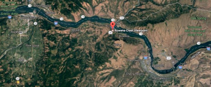
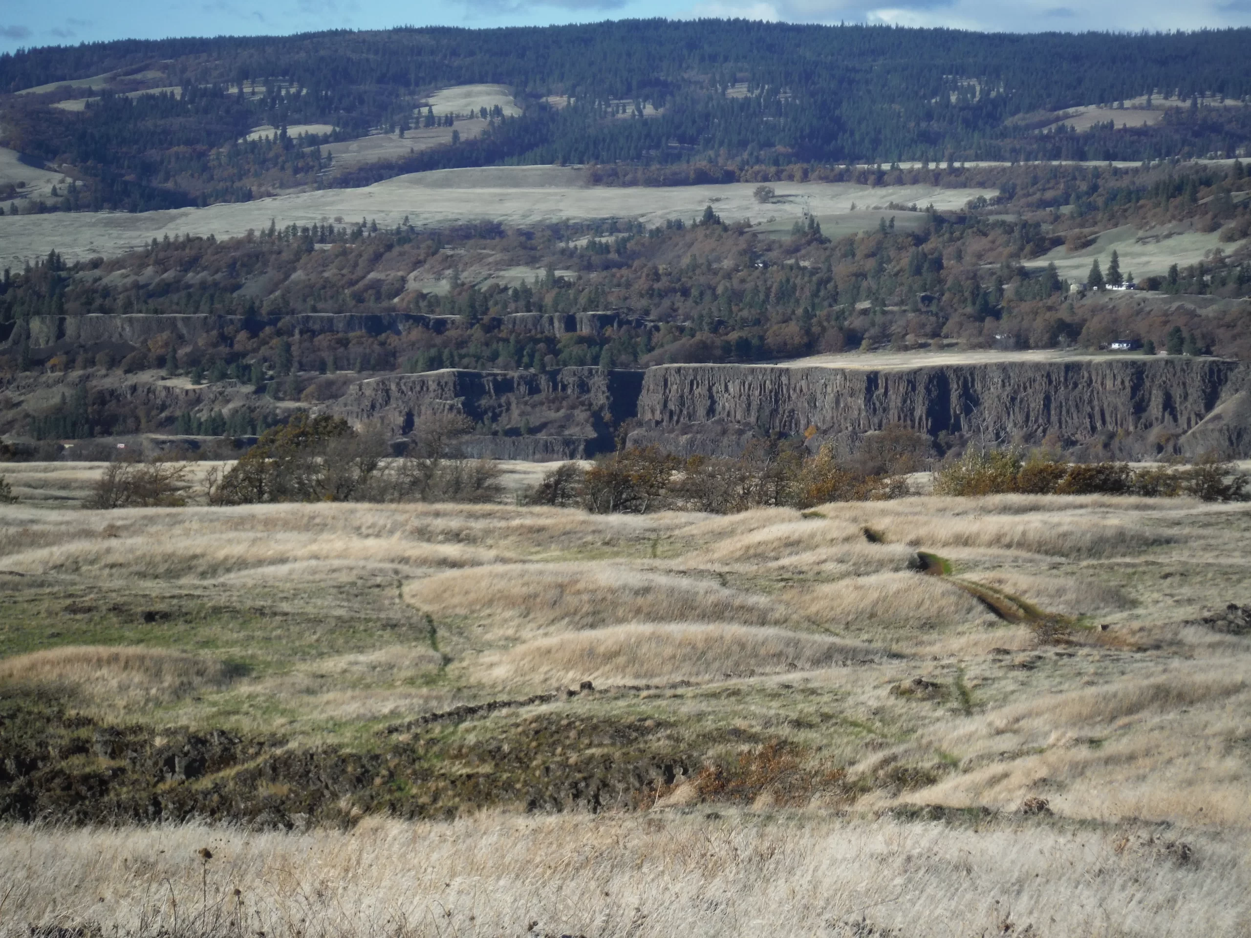
Overlooking a major chokepoint along the Ice Age Floods path, Rowena Crest lies at nearly 700 feet above the Columbia River at the upstream end of Rowena Plateau, a miles-long promontory that protrudes into the path of the river. This forces the river around the plateau through a relatively narrow section of the Gorge known as the Rowena Gap.
|
|
The onrushing Ice Age Floods waters easily flowed over the relatively low relief of Dallesport in The Dalles Basin to the east, but as they entered Rowena Gap they were impeded and diverted northward as they crashed against the Rowena promontory. This created a major chokepoint, a hydraulic dam, in the path of the floods as they made their way through the Columbia River Gorge. The flood waters hitting the Rowena promontory built to nearly 1000 feet and flowed over the Rowena Crest while backing upstream to form temporary Lake Condon in The Dalles basin.
|
|
|
|
|
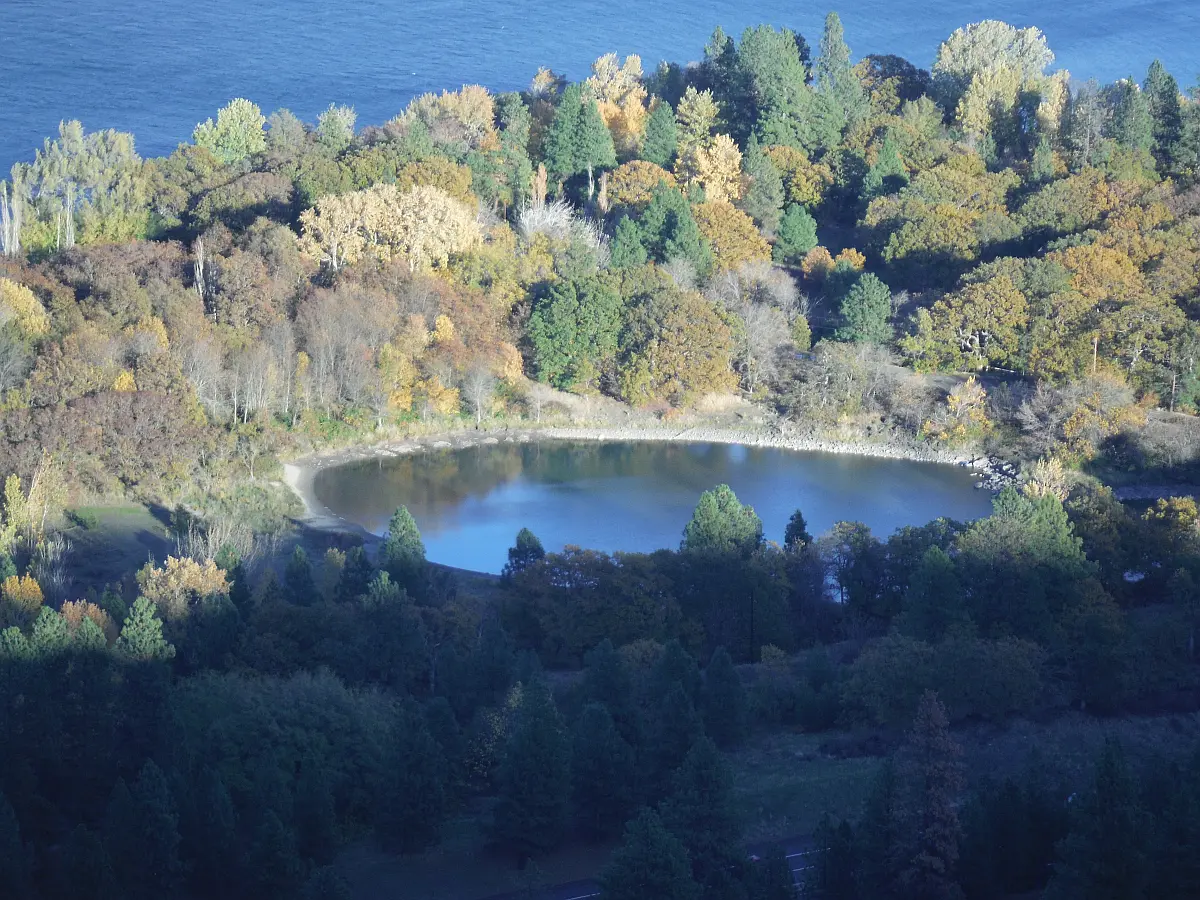
At Columbia River level below and east of the promontory is a Kolk pond formed by relatively stationary whirlpools in the flood waters where they were deflected around the Rowena Crest promontory. Other Kolk ponds can also be seen along the hiking path atop Rowena Crest where they are marked by surrounding groves of oak trees.
|
|
|
The many rounded mounds that cover the plateau are mima mounds whose origins are not definitively known, but were probably formed by turbulence at the base of the flood waters flowing over the plateau. All, that is, except for the mounds in the middle of the roundabout parking area, which were built by Oregon Dept. of Transportation to mimic those that cover the plateau.
|
|
|
|
From the vantage point of Rowena Crest Viewpoint are several compelling flood-related features. The drive to the viewpoint on old Hwy 30 from either east or west is a spectacular drive through a beautiful section of the Columbia River Gorge. A roundabout parking area at the viewpoint with a safety wall above a sheer cliff provides a great observation point.
|
|
It is estimated that each of the 40-120 Ice Age Floods may have taken up to a month to completely flush through the system to the Pacific Ocean, but the duration of the flood waters at any point along the path, like at Lake Lewis, probably lasted less than a couple of weeks.
|
|
|
|
|
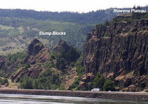
Below the block wall along the cliff edge a number of large tilted fault blocks of layered of Columbia River Basalt are slump blocks that broke off the promontory and slid toward the river as they were undercut by the flood waters coming at them from The Dalles. The relationship of these slump blocks to Rowena Crest are best viewed from the WA side of the River (see image right).
|
|
|
|
|
|
|
|
|
|
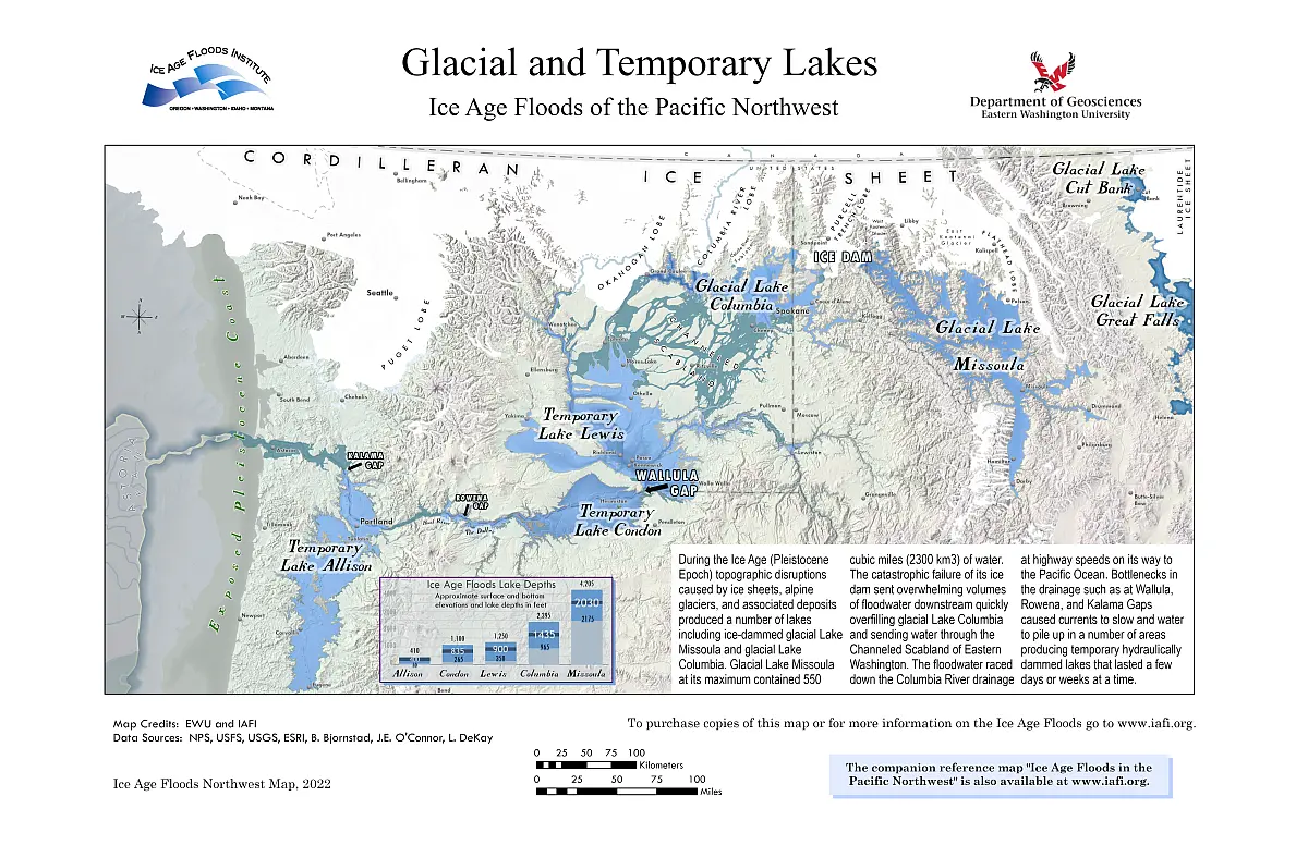
Since late last year the Ice Age Floods Institute has been working with Eastern Washington University to produce a new map showing the extent of the temporary and semi-permanent lakes associated with the Ice Age Floods. Those efforts are about to bear fruit as the new map is about to be printed to be offered in the IAFI Store.
|
|
The map is in a format similar to our very popular "Ice Age Floods in the Pacific Northwest" map and will come in two sizes, 11:x17" and 24"x36". The depicted extent of the temporary lakes and their maximum elevations are based on the best research evidence of stranded erratics and other indicators. An inset in the map also depicts the elevations and maximum water depths of each of the major temporary lakes. The map also depicts the general extent of the offshore Astoria submarine fan where the bulk of the sediment carried away by the Floods was eventually deposited.
|
|
The temporary lakes are a critical part of the Floods Story and recognizing their apparent areal extent is an important key to recognizing the size and scope of the Ice Age Floods
|
|
|
|
|
|
|
|
|
|
|
|

|
|
To date, Earth is the only planet we know of that has continents. Exactly how they formed and evolved is unclear, but we do know – because the edges of continents thousands of miles apart match up – that, at one time long ago, Earth's landmass was concentrated in one big supercontinent. Since that's not what the planet looks like today, something must have triggered that supercontinent to break apart. Now, we have new evidence to suggest that giant meteorite impacts played a significant role.
|
The smoking gun consists of crystals of the mineral zircon, excavated from a craton in Western Australia, a piece of Earth's crust that has remained stable for over a billion years. Known as the Pilbara Craton, it is the best-preserved chunk of crust on the planet… and the zircon crystals within it contain evidence of ancient meteorite impacts before the continents broke apart. "Studying the composition of oxygen isotopes in these zircon crystals revealed a 'top-down' process starting with the melting of rocks near the surface and progressing deeper, consistent with the geological effect of giant meteorite impacts," explained geologist Tim Johnson of Curtin University in Australia. "Our research provides the first solid evidence that the processes that ultimately formed the continents began with giant meteorite impacts, similar to those responsible for the extinction of the dinosaurs, but which occurred billions of years earlier."
|
|
|
The work was conducted on 26 rock samples containing fragments of zircon, dating between 3.6 and 2.9 billion years old that showed three distinct and fundamental stages in the formation and evolution of the Pilbara Craton.
|
The first stage is the formation of a large proportion of zircons consistent with partial melting of the crust. This partial melting, the researchers show, was likely the result of bombardment by meteorites, which heated the planetary crust on impact. The oldest cluster of these zircons, according to the team's interpretation, was the result of a single giant impact that led to the formation of the craton.
|
The second stage was a period of reworking and stabilization of the crustal nucleus, followed by the third stage – a period of melting and granite formation. This stabilized nucleus would then, much later, evolve to become today's continents, as did the cratons found on other continents around the world.
|
|
Many meteorites have pelted Earth in eons past, in numbers much higher than the number of continents. It's only the largest impacts that could generate enough heat to create the cratons, which appear to be twice as thick as their surrounding lithosphere. These findings are consistent with previously proposed models for the formation of cratons around the world – but constitute, the researchers said, the strongest evidence yet for the theory. However, it's just one craton, out of around 35 known. To make the evidence even stronger still, the team will need to compare their results with more samples from other cratons, to see if their model is consistent globally. "Data related to other areas of ancient continental crust on Earth appears to show patterns similar to those recognized in Western Australia," Johnson said. "We would like to test our findings on these ancient rocks to see if, as we suspect, our model is more widely applicable."
|
|
|
|
|
|
Do you have a geology question? We might have an answer!
Do you have a geologic fact to share? We have a way to do that!
|
|
Members who want to do a short article, or describe a field trip location of interest, or describe some geologic problem or site, can use our online form to submit a question or write-up to our technical committee for an answer or review before we post it on our Geology Corner page.
|
|
|
|
|
|
Upcoming IAFI Calendar Events
|
Thu Nov 17 @ 7:00 pm - Glaciers in the American West – Nov. Lower Columbia Meeting - Lower Columbia Chapter & Tualatin Historical Society
Zoom Meeting - https://us02web.zoom.us/j/89236343741
|
|
|
|
Thank You IAFI Member Supporters
|
Every member at every membership level is vital to IAFI’s continued success. Your support helps us meet our mission of providing the Ice Age Floods story to the public and continuing our work on the Ice Age Floods National Geologic Trail. Every gift counts, no matter the size. Thank you for making the IAFI what it is today and for helping shape it for the future.
|
|
|
|
|
|
Ice Age Floods Institute (IAFI) is a 501(c)(3) tax-exempt, non-profit educational organization (EIN 91-1658221), founded in 1995 and recognized as an official authority on the Ice Age Floods, providing accurate, scientific-based advice to members and the public. We were instrumental in 2009 Federal legislation authorizing National Park Service designation of the
Ice Age Floods National Geologic Trail (IAFNGT).
|
|
|
|
|
|
|
|
|