|
|
|
|
|
|
|
|
This is our 6th year preparing a Year-in-Review report for you, our members. We appreciate your continued support, friendship and membership.
|
IAFI is a non-profit organization whose main sources of income are membership dues, donations, profit from field trips and Institute Store sales. For 2022, our total income was $16,675 and our total expenses were $9,730. Our main expenses were contract labor (our membership manager) and liability insurance. At the end of 2022 we have reserves of $38,938 to cover unplanned expenses, printing informational brochures and to pursue new opportunities related to telling the floods story.
|
Our members provide most of our support and much of the reason for the various materials, activities and events we provide. In 1996, we started with 11 members, and by the end of 2022, as we continue to recover from the pandemic, we have 592 members (427 memberships) from 17 states and British Columbia.
|
|
While we have several hundred members, most of the work is done by a small group of volunteers, including all your institute and chapter leaders. We welcome anyone interested in helping develop and conduct our programs, so if you are interested please contact us at IAFInstitute@gmail.com or reach out to your chapter president or one of our board of directors.
|
INSTITUTE PROGRAMS
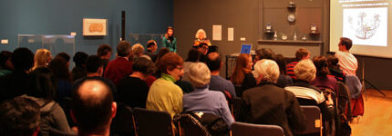
This year, while continuing to host zoom presentations, we started to have more in-person activities, although compared to a normal year, we had relatively few activities in community social settings, such as county fairs, school programs, working with other organizations, etc. We have continued our outreach to inform and educate the public about the Ice Age Floods and their long-lasting impact on our area is a key part of the IAFI mission. We have significantly increased our online outreach, typically garnering thousands of views each week through interesting articles and features on our Facebook, website and newsletters, while our local chapter programs are possibly the most effective way we meet this challenge with lectures, field trips, hikes and presentations.
|
|
IAFI chapters are continually developing ways to communicate information to help people learn about the floods. Here are some examples from 2022.
|
|
|
|
|
LECTURES
During 2022 we had both on-line Zoom presentations and in-person lectures. Over 500 people attended 18 on-line lectures and hundreds more viewed them when they were posted on YouTube. We had 27 in-person lectures which were attended by over 1200 people.
|
|
|
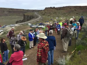
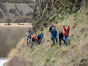
FIELD TRIPS
Ellensburg Chapter hosted two field trips: 1) Glacier Lake Foster on the Waterville Plateau and 2) Landforms and Landscapes of the Swauk Watershed.
Lake Missoula Chapter hosted a field trip to the Bison Range.
Coeur du Deluge Chapter conducted a walking field trip with Farragut State Park Docents to increase their knowledge of local Ice Age Floods features, emphasizing the location of these features within Farragut Park, how these features were formed, and how they influenced land use, transportation and recreational use.
Palouse Falls Chapter hosted a field trip to Palouse Falls.
Wenatchee Valley Erratics Chapter hosted several field trips: 1) Talk and field trip for the Tobacco Root Geological Society, 2) Field trip focusing on the Geology of the Wenatchee Valley, 3) Geology of the Leavenworth/Lake Wenatchee area.
|
|
Puget Lobe Chapter hosted a multi-day field trip to Ginkgo Petrified Forest
|
|
|
HIKES
Palouse Falls Chapter hosted a hike/lecture on the Age of Quartzite Buttes in the Palouse Region.
Lake Lewis Chapter hosted a hike/lecture to Twin Sisters in Wallula Junction. Quite cold and windy but a cool experience.
Cheney-Spokane Chapter hosted 3 hikes: 1) Dishman Hills Area, 2) along a proposed trail that the Spokane conservation District would like to develop, and 3) a geologic hike that explored the new Waikiki Springs Conservation Area on the Little Spokane River in conjunction with the Inland Northwest Land Conservancy.
Glacial Lake Missoula Chapter hosted a hike/talk to Dean Stone Mountain.
Puget Lobe Chapter hosted a hike at Ginkgo Petrified Forest
|
|
|
SCHOOL AND COMMUNITY PRESENTATIONS
To help people learn about the floods we are continually developing new ways of communicating information to people. Some examples from 2022:
Our Board of Directors Education Committee has been working on developing a 4th grade curriculum about the Ice Age Floods.
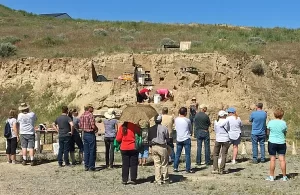
Lake Lewis Chapter and The Coyote Canyon Mammoth Site near Kennewick - Approximately 3000 people, mostly elementary school kids on school field trips, including quite a few homeschoolers, visited the mammoth site that we are excavating. The mammoth is buried in Ice Age Floods graded beds, so as we study the mammoth’s burial, we also study the floods. The stories are intertwined; hence each talk must include the Floods story. Many other kids came to the site on youth group field trips or accompanied their parents at community events. About 1000 adults and some kids also visited with us at various community events such as Heritage Days at Sacajawea State Park, The SandHill Crane Festival in Othello, The Richland Library, The Reach Interpretive Center, River Fest at Columbia Park in Kennewick and more.
Cheney-Spokane Chapter - Presented the floods story in 20-minute segments to three fourth grade classes with the Science Coordinator for Jefferson Elementary School, and exhibited at the Blue Waters Bluegrass Festival at Medical Lake, WA, visiting with 147 people.
Glacial Lake Missoula Chapter - Hosted a booth and tent at the city-wide walk-in Fort Missoula Spring Event for many passersby, and continued preparations to install glacial Lake Missoula high water indicator rocks throughout the area.
Coeur du Deluge Chapter - Led a four-hour tour in conjunction with the Idaho Master Naturalist Program on the Shawnodese tour boat along the north shore of Lake Pend Oreille and into the Clark Fork River delta viewing the Purcell trench, the location of the ice dam and the steep wall carved by the glaciation.
Columbia River Gorge Chapter - Worked to redesign and rebuild the IAFI.org website, and created new Conference displays for IAFI.
Lower Grand Coulee Chapter - Hosted a booth at the Ice Age Floods Fest at the Dry Falls Visitor Center, and one at the Quincy Farmer Consumer Awareness Day with IAFI talks and tours, videos and info displays.
Palouse Falls Chapter - Hosted an information booth at STEAM night at Lacrosse School and at the Grand Opening of remodeled Connell branch for Mid-Columbia Libraries, participated in Neighbor meeting Neighbor booth in Washtucna, a booth at Wheatland Fair, and a chapter appreciation picnic at Palouse Falls.
|
|
|
|
PARTNERSHIPS AND COLLABORATIONS WITH OTHER ORGANIZATIONS
We are always looking for other organizations to work with. This is a great way to share resources and knowledge. Some of the organizations we have worked with include:
National Park Service – We work closely with the NPS Manager of the Ice Age Floods National Geologic Trail. He attends most of our Board meetings and other significant events.
Wenatchee – Wenatchee Valley Museum and Cultural Center, Port of Quincy, Othello Sandhill Crane Festival
Coeur Du Deluge – Idaho Master Naturalist Program
Lake Lewis - Friends of Badger Mountain, Benton County Parks, The Hanford Reach Interpretative Center, Visit Tri-Cities, East Benton County Historical Museum, Franklin County Historical Museum
Cheney-Spokane – Spokane Riverfront Park board, Ice Age Floods Playground; VISIT Spokan
Palouse Falls – Whitman County Library, Lower Columbia Libraries, Lacrosse Community Pride
Lower Columbia – Tualatin Heritage Center, City of Tualatin, Tualatin Chamber of Commerce, Tualatin Ice Age Foundation, Friends of Vista House
Columbia River Gorge – Oregon Master Naturalist Program, Columbia Gorge Discovery Center, Vista House
Glacial Lake Missoula – Montana Natural History Center
Lower Grand Coulee – Coulee Corridor Consortium- Coulee Corridor National Scenic Byway; Coulee Corridor Area State Parks; Columbia Basin Trails Association
|
|
|
|
|
|
We hope you've enjoyed and found interesting what your organization has been doing during 2022.
|
We're looking forward to an even more active 2023. Gary Ford, IAFI President
|
|
|
|
|
|
|
|
I’d like to start by thanking the Ice Age Floods Institute for letting the National Park Service share regular updates on Ice Age Floods National Geologic Trail. I’m Justin Radford the Trail’s program manager and I look forward to sharing some of the work we are doing.
|
|
Last summer I had the chance to travel much of the “trail” from Missoula to Cape Disappointment. Having the opportunity to engage firsthand with the visitor experiences offered by our many partners and the amazing landscapes was certainly the highlight of the summer. Photos and stories from these site visits will bring enhancements to both the NPS App and our website in the future.
|
|
|
Last summer we also had our second annual Teacher training in Spokane, WA. 43 K-12 Teachers earned credit towards their teaching certificates by learning how to instruct with the story of the Missoula Floods in mind.
|
The calendar for 2023 is looking good. The NPS will be able to bring our traveling Ice Age Floods NGT and Lake Roosevelt NRA Mobile Visitor Center to more events like the Spokane Boat Show and the Sandhill Crane Festival this March in Othello, WA. We will be working to grow our connections with more groups across trail in 2023.
|
Thank you for your support as we continue to grow Ice Age Floods National Geologic Trail. I look forward to seeing you out on the trail.
|
|

|
|
Justin Radford, Ice Age Floods National Geologic Trail Program Manager
|
|
|
|
|
|
Come Explore the Ice Age Floods
|
|
|
|
|
|
|
|
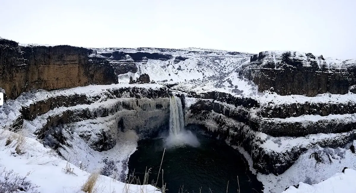
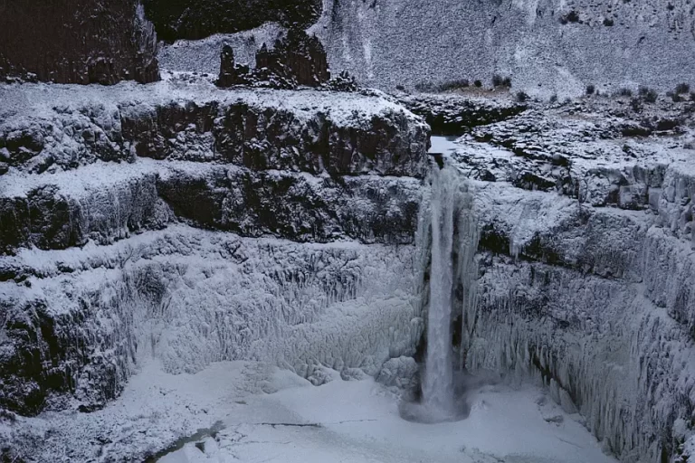
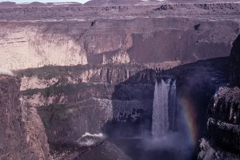
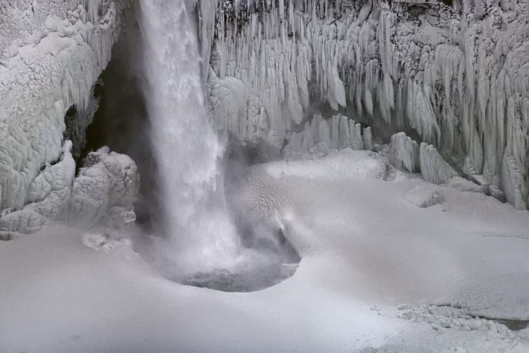
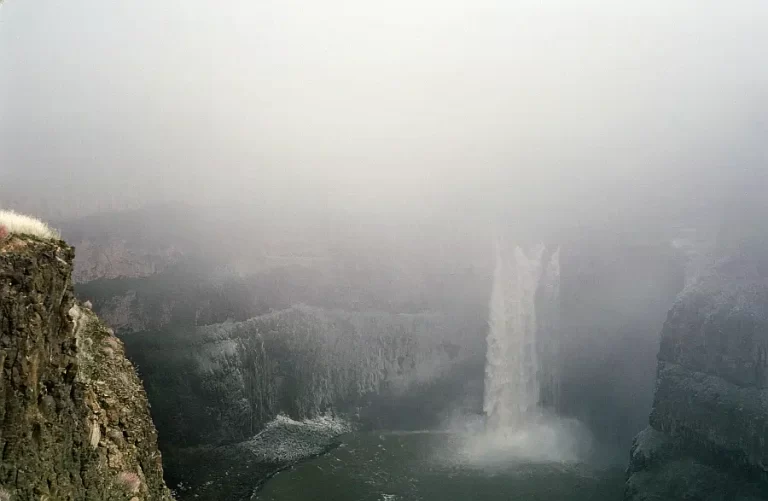
Palouse Falls is visited by thousands each year. The number has increased markedly since it became the official state waterfall of Washington in 2014. Since then, I have listened to people at the park who admit that it is their first visit and are glad they took the time to do it.
|
Most visitors come during the spring runoff when the waterflow is the highest. If that has been your only experience, I invite you to some alternative options.
|
- Consider winter after two weeks of sub-freezing weather. The spray from the falls freezes on the surrounding basalt creating an icy wonderland. The longer the cold snap, the bigger the dome of ice builds at the base of the falls.
- Arrive in the dark before the sun comes up and enjoy the first rays of daylight. Or stay until the sun sets and darkness once again envelopes the falls.
- If you want another interesting day, arrive in the dark and stay all day until the sun sets. Try to do this on a sunny day and experience the shadows as they move across the falls and sometime in the afternoon you will see a rainbow in the spray.
|
I was recently visiting with my primary physician who reminisced about his time visiting the falls with his father. He said it was almost a spiritual experience which was also expressed by the Palouse Indians who lived in the area. You may have the same feeling, especially when the crowds are much smaller in the off-season and early and late hours.
|
|
|
|
|
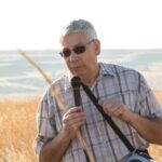
By Lloyd Stoess, Palouse Falls Chapter President
|
|
|
|
|
|
|
|
|
|
|
|
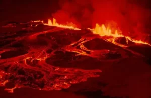
Most of north-central Washington State is covered by lava flows associated with the Miocene Columbia River Basalts. The source of these lava flows came from a series of large fissure eruptions in northeastern Oregon, southeastern Washington and west-central Idaho (similar to the eruptions currently occurring today in Hawaii).
|
|
|
|
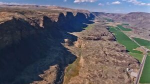
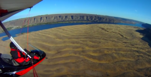
These massive outpourings of lava eventually forced the course of the Columbia River to the north and west into what we call today the “big bend”. The nature in which the basalts cooled and cracked, and the structural folding and faulting of the basalts during and after emplacement (Yakima Fold Belt), allowed the Ice Age floodwaters to sculpt large Coulees (Grand and Moses Coulees) and the channeled scabland of eastern Washington.
|
|

|
|
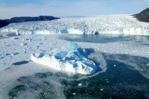
During the Pleistocene (Ice Age) over a period of about two million years, climatic conditions allowed the formation of principally two large continental ice sheets in North America. East of the Rocky Mountains was the Laurentide and to the west of the Rockies was the Cordilleran. Three principal large glacial “lobes” flowed south from the Cordilleran Ice Sheet in Canada into the Pacific Northwest. Those ice lobes are known today as the Puget, Okanogan and Purcell Trench Lobes. The Purcell Trench and Okanogan Lobes played a vital role in controlling ice age flooding and timing of flooding in north-central Washington.
|
|
|
|
During the most recent ice age advance (about 20-12 thousand years ago) the Purcell Trench Lobe was first to arrive blocking predominantly all the drainages in northwest Montana forming a large glacial lake known as Glacial Lake Missoula (GLM). Periodically the ice dam holding back GLM would break allowing Ice Age floodwaters to catastrophically escape. The initial flooding from GLM flowed principally in two directions; to the southwest down the Cheney-Palouse scabland tract, and to the west/northwest into the preexisting Columbia River drainage. During the initial flood/floods the Okanogan Lobe of the Cordilleran had not advanced far enough (south) down the Okanogan River valley to block floodwaters flowing down the Columbia River around the big bend and eventually reaching the Wenatchee area where maximum floodwater depth was almost 1,000 feet deep.
|
|
|
The advance of the Okanogan Lobe into the Columbia River valley (Bridgeport-Brewster, WA area) prevented floodwater from flowing the natural course into the Columbia valley north of Wenatchee, deflecting floodwaters into the existing Moses Coulee drainage and possibly down the beginning of Grand Coulee. Floodwaters flowing down Moses Coulee formed a large bar across the Columbia River valley south of Wenatchee, Washington, forming a large temporary lake in the Wenatchee valley until water became deep enough to erode down through the bar and empty the lake. Evidence in the Moses Coulee bar deposit reflects four distinct “basalt” dominated flood beds indicating four separate flooding episodes.
|
|
|
|
|
|
Note that about the same time as the Okanogan Ice Lobe advanced into the Columbia Valley, another glacial lake started forming behind this ice dam, known today as Glacial Lake Columbia (GLC). As GLC filled, flooding continued down Moses Coulee and became more prominent down the beginning of Grand Coulee. Eventually the Okanogan Lobe advanced up onto the Waterville Plateau and blocked the upper portion of Moses Coulee thus ice-age floodwaters could no longer flow down Moses Coulee.
|
|
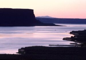
Banks Lake & Steamboat Rock
|
|
|
With the blocking of Moses Coulee, GLC filled and flowed down the Grand Coulee drainage. During this time, when the Okanogan Lobe blocked the Columbia River drainage around the big bend, natural flow of the Columbia River was down the Grand Coulee drainage. Flood waters flowing down the Grand Coulee went over two separate folds in the basalt. An extension of the Beezley Hills anticline allowed a southern waterfall or “cataract” to form near Soap Lake, Washington. Another fold in the basalt, the Coulee Monocline, located just a few miles north of Coulee City, Washington, was the starting site of the upper falls or cataract. These two cataracts were simultaneously being eroded and “prograded upstream” with each subsequent Missoula Flood down the Grand Coulee drainage.
|
|
During this time when GLC was at its maximum depth and flowing naturally down Grand Coulee, floods out of GLM would overtop lower divides and flow into the Telford and Wilson Creek floodways eventually meeting up with floodwaters down Crab Creek. As the Purcell Trench Lobe waned and flooding episodes became smaller and more frequent, these smaller flooding events were still able to overtop the lower divides along the south side of the Columbia River drainage due to the high water level in GLC.
|
The upper cataract in Grand Coulee eventually “breached” the existing Columbia River valley drainage near Grand Coulee, Washington. This breaching lowered the northern opening into Grand Coulee close to 500 feet lower than other divides to the east, making it the predominate flood pathway for the remainder of smaller and more frequent GLM floods. These later smaller GLM floods were not large enough in volume to overtop previous divide drainages to the east of Grand Coulee. The terminus of the lower Grand Coulee is marked by “Dry Falls” cataract.
|
|
The Purcell Trench Lobe eventually retreated north (melted back). With no ice dam blocking the drainages in northwest Montana, GLM could no longer exist. The Okanogan Lobe still blocked the Columbia River drainage west of Grand Coulee and GLC existed for about another 300 years after the last GLM flood based on glacial lake sediment (glacial varves) evidence.
|
|
|
Finally the Okanogan Lobe melted enough that one last catastrophic ice age flooding event from the emptying of GLC occurred down the Columbia River valley into the Wenatchee, Washington area and south along the preexisting Columbia River. It is believed that West Bar south of Trinidad, Washington, was formed from the demise of GLC. A small bar adjacent to West Bar may be evidence for one last small flood, after the demise of GLC, down the Columbia River drainage.
|
|
|
The existing topography, the timing and position of the Purcell Trench and Okanogan Lobes, and the unique nature in which the basalt eroded has played a significant role in the development of Ice Age flood pathways in north-central Washington.
|
|
|
|
|
|
|
By Brent Cunderla, Wenatchee Valley Erratics Chapter President
|
|
|
|
|
|
Do you have a geology question? We might have an answer!
Do you have a geologic fact to share? We have a way to do that!
|
|
Members who want to do a short article, or describe a field trip location of interest, or describe some geologic problem or site, can use our online form to submit a question or write-up to our technical committee for an answer or review before we post it on our Geology Corner page.
|
|
|
|
|
|
Upcoming Calendar Events
|
|
Jan 15 - Pleistocene Post – IAFI’s Quarterly Newsletter
|
|
Feb 14 @ 7:00 pm - Ralph Dawes Presents “The Wenatchee Pinnacles”
|
|
Feb 16 @ 7:00 pm - Lower Columbia Chapter Meeting
|
|
Mar 6 @ 7:00 pm – 8:45 pm - Tim Connor, “Beautiful Wounds” a Scablands Sojourn
|
|
Mar 16 @ 7:00 pm - Lower Columbia Chapter Meeting
|
|
Mar 24 – Mar 26 - Othello Sandhill Crane Festival @ Othello, WA
|
|
Apr 2 - Geologist’s Day – 1st Sunday in April
|
|
Apr 15 - Pleistocene Post – IAFI’s Quarterly Newsletter
|
|
Apr 20 @ 7:00 pm - Lower Columbia Chapter Meeting
|
|
May 18 @ 7:00 pm - Lower Columbia Chapter Meeting
|
|
Jun 2 – Jun 3 - IAFI Rock-Out Jubilee Membership Meeting @ Dry Falls Camp Delany, Sun Lakes State Park
|
|
Jun 5 – Jun 9 - GSA Penrose Conference – The Role of Outburst Floods in Earth and Planetary Evolution @ Camp Delany - Sun Lakes State Park
|
Jun 15 @ 7:00 pm - Lower Columbia Chapter Meeting
|
|
|
|
THANK YOU IAFI MEMBER SUPPORTERS
January-December 2022- We've seen a tremendous outpouring of support this year.
Every member at every membership level is vital to IAFI’s continued success. Your support helps us meet our mission of providing the Ice Age Floods story to the public and continuing our work on the Ice Age Floods National Geologic Trail. Every gift counts, no matter the size. Thank you for making the IAFI what it is today and for helping shape it for the future.
|
|
|
|
Sustainers
|
|
|
Barnes, Don & Christine
Beach, Jay
Brown, Louise M.
Cunderla, Brent & Vickie
Freiberg, Susan D.
Frith, Richard & Judy Hademan-Frith
Gilman, Jena
Gray, Dodie & Paul
Holmes, Brian G.
Lacy, Ken & Susan
|
|
Marlow, Gary
McGregor, Alex & Linda
Phillips, Loren (family)
Redd, Ray
Schmelzer, Jeff
Strobeck, Jan
Teegarden, Michael
Trautwein, Steven N.
Van Wyck, Harriet
Wheelon, Dean
|
|
|
|
|
|
Andrews, Phil & Donna Oberembt
Ayers, Brian & Ann M.
Beaufait, Mark S.
Bowman, Sandra (family)
Boyd, Nancy Fenno
Brinkerhoff, Van
Bruntlett, Jean (family)
Bulzomi, Steve & Linda
Burden, Lys (family)
Burman, Stan
Carlisle, Russell
Carstens, David
Chadbourne, Donald
Chatham, Cynde & Alan
Clemens, Catherine & Daniel Speth
Cocchiarella, Ronald
Copley, Windsor & Pam
Davis, Steve & Mary
Engstrom, William & Julie
Erb, David
Ford, Gary & Barbara
Fritz, Daniel
Garwood, Dean & Amy
Gooley, Ron & Carolyn
Guntermann, Chris & Christine Krueger
Hennings, Erika & Curtis
Huber, Douglas
Isenberg, Jonathan
Jacks, Jim
Jackson, Sandra
Jamieson, Pat
Jividen, Bruce
Kemp, Lola Helen
Kleinknecht, Dick
Lewis, Richard
|
|
Mamajek, Ron & Denise Zembryki
Marquardt, Glenn
McClure, Brian
McGregor, Andy
McGregor, Mary & John Bolles
McKillop, Mark
Mease, Mark
Middleton, Jack & Anne
Mikkelsen, P. Erik & Kari Angell-Petersen
Miller, Joan & Dragila, Timothy
Millsap, Michael G.
Miskowiec III, C. Victor & Susanne Yarbrough
Moline, D. Kent & Marie Bjork
Moody, John Robert & Sharon E.
Murray, Chris & Carla Chiotti
Myers, Kathleen
Neyland, Roger, Leslie & Roy
Pare, Shawn
Parry, Laird & Shawna
Patrouch, John & Linda Jean Hartman-
Perkins, John
Peterson, John R.
Roth, Randy
Schraer, Cynthia
Smithson, Craig
Stevenson, Roger
Tays, Gerald & Nancy
Trivelpiece, Jim & Ann Warrington
Vallem, Robert
Vance, Paul W.
Washington, Steven L. & Lynn
Williams, Wayne
|
|
|
|
|
|
Fay, Richard
Gordon, Carrie
Larsen, Ellen
Mead, Ted
|
|
Melhorn, Timothy L.
Saunders, Deshawn
Shell Oil Co.
Thorsen, Eric
|
|
|
|
|
|
Ice Age Floods Institute (IAFI) is a 501(c)(3) tax-exempt, non-profit educational organization (EIN 91-1658221), founded in 1995 and recognized as an official authority on the Ice Age Floods, providing accurate, scientific-based advice to members and the public. We were instrumental in 2009 Federal legislation authorizing National Park Service designation of the
Ice Age Floods National Geologic Trail (IAFNGT).
|
|
|
|
|
|
|
|
|