GO PLACES! DO THINGS!

Along the ICE AGE FLOODS
NATIONAL GEOLOGIC TRAIL


The Ice Age Floods National Geologic Trail covers some 16,000 square miles (41,440 km2) in present day Montana, Idaho, Washington, and Oregon. We have hand picked some of the best of the best places along the Trail and present them here for you enjoy and explore! Check back often, we will be adding new and wonderful destinations for your entire Family to enjoy!

MONTANAIDAHOWASHINGTONOREGON

SOME PLACES TO GO and THINGS TO DO in MONTANA

Bison Range

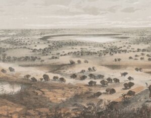
Bison Range The Bison Range was established by President Theodore Roosevelt in 1908 to conserve the American Bison.  Since that time it has been managed as a wildlife refuge and native grassland. Today the management is done by the Confederated Salish and Kootenai Tribes. The range is a small, low-rolling mountain connected to the Mission Mountain Range by a gradually descending spur. Range elevation varies from 2,585 feet (788 m) at headquarters to 4,885 feet (1,489 m) at High Point on Red Sleep Mountain, the highest point on the Range.  Much of the Bison Range was once under prehistoric Glacial Lake Missoula. The upper part of the Range was above water. Red Sleep Mountain scenic drive leads to this high point, which has spectacular views across what was once the lake to the Mission Mountains on the other side.  Other flood features are evident on Buffalo Prairie scenic drive. Old beach lines (strandlines) can be seen on north-facing slopes and some large erratics are located near the old corrals. There is a visitor center near the entrance which has a display and videos of Glacial Lake Missoula as well as information on the tribes of the Flathead Reservation and the abundant wildlife, including birds, bears and antelope.  There is also a gift shop.  Camas Prairie ripples and several other important features of Glacial Lake Missoula are in close proximity to this site, much of them are located on tribal lands.  The entrance is off US 93 and MT 212 N about an hour north of Missoula. Bison Range58355 Bison Range Rd, Moiese, MT (406) 644-2661 bisonrange.org FEES – there is a fee for entrance, including the day use area, except for CSKT tribal members OPEN HOURSWinter Hours (Nov-April)Gate: 8am–6pmVisitors Center: 8am–5pm Red Sleep Drive: closed Buffalo Prairie Drive: 8am-6pm Summer Hours (May-Oct)Gate: 7am–8pmVisitors Center: 8am–7pm Red Sleep Drive: 8am–7pm Buffalo Prairie Drive:8am–8pm  Restrictions: Vehicles over 30 feet long and those owing trailers as well as motorcycles, ATVs, and bicycles are not allowed on either drive.  Visitors must remain inside vehicles at all times except for designated areas      

Read More »

Erratic in the Bitterroot

An 8 ton erratic left behind by Glacial Lake Missoula in the Bitterroot Valley on the property of a local rancher was relocated to serve as the focal point of an outdoor kiosk exhibit at the Ravalli County Museum at the former County Courthouse, 205 Bedford Street in Hamilton.  Unlike their counterparts at other location along the National Geologic Trail, erratics in this part of the Ice Age Floods did not come from Canada nor did they travel as far, but the action of the floodwaters and iceberg rafts is equally evident despite more shallow waters. There are similar erratics found elsewhere in Bitterroot, on the campus of the University of Montana, and at the Bison Range. The outdoor display tells the same story as other locations on the Ice Age Floods National Geologic Trail but also includes information on two other National Park Service trails that pass through this area – the Nez Perce and the Lewis and Clark National Historic Trails.  The museum has other indoor exhibits of historical interest and about Glacial Lake Missoula.    

Read More »

Glacial Lake Missoula National Natural Landmark

Glacial Lake Missoula National Natural Landmark Ice Age Floods National Geologic Trail Glacial Lake Missoula was the largest of several lakes impounded by the Cordilleran Ice Sheet in the Northern Rocky Mountains during the Quaternary period. The lake was approximately 2,900 square miles in size and contained more than 500 cubic miles of water. It occupied the Mission, Jocko and Little Bitterroot valleys, drained by the Flathead River; and the Missoula, Ninemile and Bitterroot valleys, drained by the Clark Fork River. The lake was formed by an ice dam across the mouth of the Clark Fork River at Lake Pend Oreille, Idaho, a result of successive advances of a lobe of the Cordilleran Ice Sheet. The site is located 12 miles north of Perma, Montana. At least three and possibly more than 100 separate collapses of the ice dam, possibly coincident with periods of ice retreat, caused the lake to drain, producing catastrophic floods across the Columbia Plateau and down the Columbia River Basin. It is estimated that the waters of Glacial Lake Missoula, 1,000 feet deep at Eddy Narrows, were withdrawn at a peak discharge rate of 10 cubic miles per hour. Approximately 550 cubic miles of water passed through those narrows during withdrawal. Evidence of this catastrophic withdrawal can be found in scourings, high eddy deposits of flood debris, flood bars of boulders and course gravel, and successions of giant arcuate ripples or ridges of gravel resting on bedrock surfaces. Ripples appear as ridges 15 to 50 feet high, 100 to 250 feet wide, and from 300 feet to a half-mile long. While the form, structure and arrangement of these features are similar to that of ordinary current ripple marks, they are termed giant flood ripples, due to their large size. The giant flood ripples at this site are unusual due to their being on the down-current side of notches in a ridge separating two basins that were both subsidiary to the main course of Lake Missoula in the Clark Fork Valley. The best examples of giant flood ripples are found in Camas Prairie. Quick Facts Designation:National Natural Landmark OPEN TO PUBLIC:Private Land, closed to the public, but features throughout the area are visible from many vantage points.

Read More »
SOME PLACES TO GO and THINGS TO DO in IDAHO

Museum of North Idaho

Museum of North Idaho IceAgeFloods National GeologicTrail “The Museum of North Idaho collects, preserves and interprets the history of the Coeur d’Alene Region. to foster appreciation of the area’s heritage.” In the 1960s, the North Idaho Hoo Hoo Club, an organization of loggers, lumbermen and foresters, first entertained the idea of establishing a museum. They incorporated on May 1, 1968 for a museum focusing on the history of the Coeur d’Alene Region (Kootenai, Benewah and part of Shoshone counties). Through the efforts of volunteers and community support, the Museum opened its doors on the North Idaho College campus on July 28, 1973. In 1979, they remodeled a City-owned building and relocated to its current location. Quick Facts Location: 115 Northwest Blvd, Coeur d’Alene, ID 83814Phone: (208) 664-3448 The Museum is open Tuesday to Saturday from 11 am – 5 pm.

Read More »

Glacial Dam at Green Monarch Ridge View Point

Glacial Lobe Dam at Green Monarch Ridge View Point Ice Age Floods National Geologic Trail  As the Purcell Trench ice lobe of the Cordilleran Ice Sheet advanced south from Canada, it was stopped by the Green Monarch Ridge, building an ice dam 4,000 feet (1219 m) tall and nearly 40 miles (64 km) wide that blocked the Clark Fork river, thus filling glacial Lake Missoula. View the Green Monarch Ridge and the Purcell Trench from a large pullout on Idaho State Route 200, about one mile (1.6 km) west of Hope, Idaho and 15 miles (24 km) east of Sandpoint, Idaho. Quick Facts Location: Idaho State Route 200, about one mile west of Hope, Idaho and 15 miles  east of Sandpoint, Idaho.

Read More »

Lake Pend Oreille

Lake Pend Oreille Ice Age Floods National Geologic Trail  The Purcell Lobe of the Cordilleran Ice Sheet repeatedly formed a 2000′ tall ice dam in this area, which backed up Glacial Lake Missoula and eventually burst catastrophically, releasing Ice Age Floods as often as about every ~10-60 years. Lake Pend Oreille is the largest lake in Idaho. The lake level is 2062 ft above sea level, with the surrounding terrain as high as 6002 ft. With a maximum depth of 1150 ft, this lake is the 5th deepest in the US. The location of the lake is probably related to an old river valley controlled by faults. The Lake Pend Oreille basin was carved by the repeated advances of Pleistocene ice and scoured by Ice Age Floods. With the waning of flood waters, the basin was filled with glacial out-wash and flood deposits. The lake is dammed at the south end by thick glacial and flood deposits that mark the beginning of the “Outburst Deposits”Quick Facts MANAGED BY:US Forest Service

Read More »
SOME PLACES TO GO and THINGS TO DO in WASHINGTON

Ginkgo Petrified Forest

Ginkgo Petrified Forest State Park Interpretive Center Ginkgo Petrified Forest State Park is a registered National Natural Landmark, lyng just north of US-90 at exit 136, and west of the Wanapum Lake portion of the Columbia River at Vantage, WA. Established in 1935, it is

Read More »

Fort Spokane Visitor Center

Fort Spokane Visitor Center Ice Age Floods National Geologic Trail “Fort Spokane is one of the cultural jewels of Lake Roosevelt National Recreation Area. For thousands of years, the area was a gathering place for native tribes fishing the rapids of the Spokane River. In

Read More »

Moses Coulee: An Ice Age Enigma

Washington state is famous for its dramatic landscapes, many carved by the immense power of the Ice Age Floods. We know the stories of the Grand Coulee, Palouse Canyon, and the Potholes. But tucked away in north-central Washington, cutting a path from northeast to southwest

Read More »
SOME PLACES TO GO and THINGS TO DO in OREGON

Oregon Museum of Science and Industry

Oregon Museum of Science and Industry Ice Age Floods National Geologic Trail The Oregon Museum of Science and Industry (OMSI) in Portland, Oregon, was founded in 1944. OMSI is one of the nation’s leading science museums and a trusted educational resource for communities throughout Oregon

Read More »

Museum of Natural History, University of Oregon

Museum of Natural and Cultural History, University of Oregon The museum offers a variety of seasonal and year-round programs for science and culture enthusiasts of every age. Delve into Oregon’s story, from the archaeology of the First Americans to the dynamic cultures of today’s Tribes.

Read More »
Even MORE PLACES TO GO and THINGS TO DO

Click a STATE for MORE PLACES TO GO and THINGS TO DO

MONTANAIDAHOWASHINGTONOREGON

Share this article:

Like this:

Like Loading...