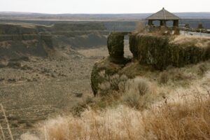
Camas Prairie Ripples
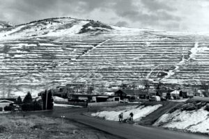
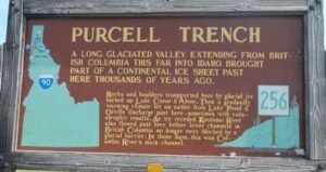
Camas Prairie Ripples The Camas Prairie Ripples, located 12 miles north of Perma, Montana, appear as prominent ridges 15 to 50 feet high, 100 to 250 feet wide, and from 300 feet to a half-mile long – the largest ripples on earth. While the form, structure and arrangement of these features are similar to that of ordinary current ripple marks, they are termed giant flood ripples, due to their large size. Most ripples that are formed by rivers today are only inches high and are mostly made up of sand-sized particles. Many of the Camas Prairie ripples are composed of boulder-sized geologic debris, and since the size of ripples is related to the strength of a river’s currents, these ripples were created by currents so powerful they are difficult to comprehend. The best examples of giant flood ripples are found in Camas Prairie. The Camas Prairie Ripples were formed by strong currents associated with as many as 40 to 100 emptyings of Glacial Lake Missoula over 4,000 years beginning some 17,000 years ago. Glacial Lake Missoula was formed by a massive lobe of the Pleistocene Cordilleran ice sheet that blocked the mouth of the Clark Fork River at Lake Pend Oreille, Idaho, a result of successive advances of the Cordilleran Ice Sheet during the Ice Age, when mammoths, saber-toothed cats, and giant ground sloths still roamed the landscape. It was the largest of several lakes impounded by the Cordilleran Ice Sheet in the Northern Rocky Mountains during the Quaternary period. The lake that formed behind the ice dam expanded until it was 3,000 square miles, held 500 cubic miles of water, and was 2,000 feet deep – as big as Lakes Erie and Ontario combined. It occupied the Mission, Jocko and Little Bitterroot valleys, drained by the Flathead River; and the Missoula, Ninemile and Bitterroot valleys, drained by the Clark Fork River. When the ice dam eventually collapsed Glacial Lake Missoula emptied catastrophically to the west on across the Columbia Plateau and down the Columbia River Basin, its waters moving at maximum speeds of 80 miles per hour to the Pacific Ocean. The flood waters ran with the force equal to 60 Amazon Rivers and moved car-sized boulders up to 500 miles, embedded in icebergs from the failed ice dam. It occupied the Mission, Jocko and Little Bitterroot valleys, drained by the Flathead River; and the Missoula, Ninemile and Bitterroot valleys, drained by the Clark Fork River. It is estimated that the catastrophic flood waters of Glacial Lake Missoula, 1,000 feet deep at Eddy Narrows, drained at a peak discharge rate of 10 cubic miles per hour. Approximately 380 cubic miles of water passed through those narrows, during withdrawal. Evidence of this catastrophic withdrawal can be found in scourings, high eddy deposits of flood debris, flood bars of boulders and course gravel, and successions of giant arcuate ripples or ridges of gravel resting on bedrock surfaces. The giant flood ripples at this site are unusual due to their being on the down-current side of notches in a ridge separating two basins that were both subsidiary to the main course of Lake Missoula in the Clark Fork Valley. Flathead Land Trust’s largest conservation easement protects 3,867 acres of the Camas Prairie near Hot Springs. The rolling grasslands of the Camaroot Ranch were first homesteaded in 1910, the year the Flathead Indian Reservation was first open to land acquisition. The Cross family’s ownership began in 1920 when Sid Cross’s grandparents, John and Anna Lauraman, first acquired 160 acres. They and other relatives continued to acquire surrounding land over the next several decades. At one time the ranch totaled almost 6,000 acres. Parts of three homesteads still remain on the property including a 2-story house and old barn that was built in the 1920s where Anna Lauraman grew up. The ranch was used for grazing cows and horses, and raising some crops such as alfalfa and wheat. The Cross family sold the property to the Confederated Salish and Kootenai Tribe in 2015. The conservation easement on this unique property preserves open space, agricultural land, and the giant ripples as silent monuments of Montana’s prehistoric and chaotic past. The locale includes a mixture of private, public and landtrust lands throughout the Camas Prairie area.